 Occasional Papers (2009-)
 Site Visualisations
Understanding the setting of an archaeological site has two components: an experience of its location, from a human standpoint (standing, sitting, observing), and an appreciation of its position (on a map, an aerial photograph, or a satellite image). Each has its own genre of representations. One conveys a direct engagement with an immediate visual field, the other is a distanced appreciation which was probably not available to its original inhabitants – except in the imagination (see for instance the Nazca Lines). The combination of these two viewpoints is rarely attempted, perhaps because they belong to different intellectual traditions: the Romantic and the Enlightenment projects, respectively.
Just as high-resolution satellite imagery allows us to zoom effortlessly between a local and a global scale, eroding the artificial contrast between explanations constructed in local terms (e.g. ethnography) and those constructed in global terms (e.g. world systems theory), so the manipulation of digital images in 3D is eroding the contrast between map-like vertical images and horizontal views. Traditional, paper-based modes of representation had already attempted to overcome this polarity (in the form of block diagrams, or imagined perspectives like the vue cavaliére), but it is only with digital storage and high-speed graphics capabilities that the potential of interactive images has emerged (see VRML (3D) images). These allow the image to be tilted (as well as rotated), so giving the whole spectrum of viewpoints from the ground-level to the vertical.
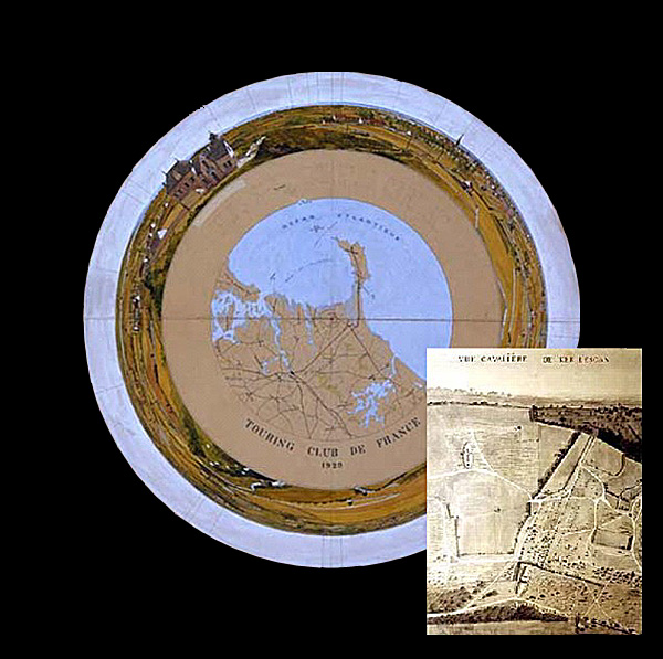
Early representations of French megalithic monuments: left, a circular panorama of the Carnac alignments from the top of the Neolithic tumulus of Mont St-Michel (Touring Club de France, 1932); right, an imagined oblique aerial view (vue cavaliere, literally "horse-rider's view") of the alignments of Kerlescan (later 19th century).
High-speed graphics have also brought fresh potential to a traditional mode of representation, the panorama. Conventional representations usually adopt a frame, limiting the viewpoint to a specific direction and set dimensions. From time to time, topographic artists and photographers have rebelled against this convention, and tried to present a compound viewpoint obtained by rotating the direction of vision (or by using a "fish-eye" lens). Several modern graphics packages offer the facility to stitch together a series of overlapping images, and to combine them into a single structure which can be explored by moving right or left, up or down. The end-product is a composite, in the same way as an air-photo or satellite mosaic (and therefore "filtered" in some way to achieve a seamless representation). The most sophisticated panoramic representations can be viewed through 360 degrees in the horizontal plane and 180 degrees in the vertical. The examples shown here are rather simpler, and constructed from sequences of photographs taken from the summits of mounds during field visits to monuments visible on satellite images. (Not all of these offer unobstructed views: the summit is often crowned with a water-tower, a radio transmitter, or just a flagpole!). However – unlike satellite images – they offer the opportunity to look out at the surrounding countryside in a way which would have been possible for their inhabitants. They thus give a situated view of the landscape, even though this may have changed radically since the site was occupied.
Panoramas thus offer a natural complement to the vertical or near-vertical views which predominate on these web-pages, because of their comparability within a common framework (georeferencing). The panorama offers a specific view from a specific place (though it does not exhaust the range of possibilities, and offers – as with a single satellite image – a particular point in a seasonal or daily cycle, and at a specific time). As with vertical images or representations on different scales, an appreciation of the total situation is best achieved by "tacking" between different angles of vision. This in itself offers a metaphor for our intellectual appreciation of different points of view in the interpretation of ancient sites and their landscapes: a single perspective is never capable of conveying the totality. This website tries to provide points of view – literal or metaphorical – which offer fresh opportunities to see ancient landscapes from new angles.
Site Panoramas
Click on the panorama thumbnails below to view the Interactive panoramas.
You will need a program like Quicktime Player to view them on your browser. Due to their size, these files may take some time to load.

<blockquote>
<a target='_blank'href='/content_media/atlas/panoramas/Movies/Vincha.mov'>The Neolithic tell of
Vinča (Serbia)</a> during excavation in the early 1930s (c. 180° view)<br>
<br>
The 12 m high tell of Vinča, on the bank of the Danube near Belgrade, was
one of the classic early Balkan excavations, undertaken between 1911 and
1934 by Miloje Vasić (Vassits). This panorama view (mounted by the
photographer) was taken by Miss Fanny Foster, who acted as photographer to
the expedition in the 1930s (copyright: Ashmolean Museum, Oxford). It
shows the excavation profile, parallel to the river, with charming details
of the excavators.<br>
<br>
M. M. Vasić, <i>Preistorijska Vinča</i> I-IV (Beograd 1936).<br>
<a target='_blank' href='http://www.rastko.org.yu/arheologija/vinca/vinca_eng.html'>
http://www.rastko.org.yu/arheologija/vinca/vinca_eng.html</a><br>
<a target='_blank' href='http://www.online-archaeology.com/index.htm'>
http://www.online-archaeology.com/index.htm</a></blockquote>
<p class='center'><a target='_blank' href='/content_media/atlas/panoramas/Movies/Karahoyuk.mov'>
<img border='0' src='/content_media/atlas/panoramas/Thumbnails/Karahoyukpan2.jpg' width='700' height='123'></a></p>
Karahöyük, Elbistan, Turkey: a major Chalcolithic and Bronze Age tell site (c. 180° prospect)
Karahöyük is one of the largest tells in the Elbistan basin, between the Taurus and Antitaurus mountains. It was a major centre in Hittite times. (Photo: Andrew Sherratt, August 2005).
Brown, G. H. 1967 "Prehistoric pottery from the Antitaurus" Anatolian Studies 17, 123-64.
http://www.tayproject.org/TAYmaster.fm$Retrieve?YerlesmeNo=1457&html=masterengdetail.html
&layout=web
<p class='center'><a target='_blank' href='/content_media/atlas/panoramas/Movies/Arslantepe.mov'>
<img border='0' src='/content_media/atlas/panoramas/Thumbnails/Arslantepepan2.jpg' width='700' height='130'></a></p>
<blockquote>
<a target='_blank' href='/content_media/atlas/panoramas/Movies/Arslantepe.mov'>Arslantepe, Malatya,
Turkey (ancient Melid)</a>: a major regional centre in the Chalcolithic,
Bronze and Iron Ages (c. 180° prospect)<br>
<br>
Arslantepe has been the subject of a sustained campaign of excavations by
an Italian team currently directed by Professor Marcella Frangipane, La
Sapienza University, Rome, which has revealed unique evidence of a
sequence of fourth millennium temples with their wall-paintings and
administrative practices (seals and sealings), as well as substantial
subsequent occupation. (Photo: Andrew Sherratt, August 2005).<br>
<br>
Frangipane, M. (ed.) 2004 <i>Arslantepe</i> (Exhibition catalogue: <i>Alle
origini del potere – Arslantepe, la collina dei leoni</i>, Rome 2004), Rome:
Electa.<br>
<a target='_blank' href='http://w3.uniroma1.it/arslantepe/the%20site.htm'>
http://w3.uniroma1.it/arslantepe/the%20site.htm</a><br>
<br>
<a target='_blank' href='http://www.misart.it/hpmisart/biblio.cfm?idmissione=2'>
http://www.misart.it/hpmisart/biblio.cfm?idmissione=2</a></blockquote>
See also panoramas from the Stoa Consortium's 'Metis' collection of panoramas of classical sites.