 Occasional Papers (2009-)
 Site Visualisations
What is a tell? The ancient settlements of the Near East, from the Neolithic period to the Bronze Age, typically form large artificial mounds which are known from their Arabic name as tell sites. These form characteristic features of the landscape over an area reaching from Balkan Europe to north-west India. They occur in areas of low rainfall, where mudbrick was used as a construction-material. The accumulation of settlement debris seems to have been deliberately encouraged, to raise the villages above the plain for environmental reasons (protection from floods, ventilation) and increasingly also for defence. Because these settlements were typically located in optimal positions adjacent to water-sources and fertile land, they were often occupied more or less continuously for many millennia. Some developed into towns or cities, and achieved considerable size, with fortifications and sometimes extended urban areas. Not all sites at this time took the form of mounds, and the tell-mounds themselves were usually abandoned by the Iron Age in favour of flat settlements, though some (like Arbil in Iraq) are still occupied today (see picture).
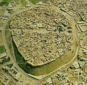
Arbil, Iraq: a living tell.
These sites thus span a whole range of categories, from cities to small villages or hamlets, and the distribution of the larger examples gives a good idea of the extent of early land-occupation and the structure of settlement within it. Only a tiny proportion of them have been excavated, and only a minority have even been recorded. Much archaeological fieldwork is devoted to locating and plotting them, and dating them by the characteristic forms of pottery which they contain. Their study allows a systematic view of patterns of settlement and social organization as they changed through time.
These "accidental monuments" thus form an invaluable resource for archaeology, since they preserve a record of the material culture of successive communities, with characteristic architecture and broken artefacts of everyday life, covering the millennia which saw the emergence of farming and village life and the growth of the first urban communities. They are precious relics of a formative period of prehistory and early history. Today, with large-scale alteration of the landscape for agriculture, industry and transport, they are subject to an unparalleled degree of destruction. It is thus vital to accumulate as complete a record as possible of these relics of early human habitation, which are the primary evidence for reconstructing ancient ways of life and the development of early societies.
For an excellent introduction to the landscape archaeology of the Near East, by a writer who has been at the forefront of the investigation of tell sites, seeArchaeological Landscapes of the Near East by Tony J Wilkinson (2004). See an extract; read a review.
Archaeology’s telescope
The information gained from satellite imagery forms a major resource for investigating such sites. The first imagery with sufficient resolution to provide recognizable pictures of tells was CORONA imagery taken from 1960-72 for military purposes and de-classified by the US government from 1995 onwards. This was eagerly acquired and analysed by archaeologists working on the early settlement-history of the Near East, notably Jason Ur and Carrie Hritz (then doing PhDs in Chicago) and Jennifer Pournelle (then doing a PhD in San Diego). These provided a new perspective on key areas of early urban life.
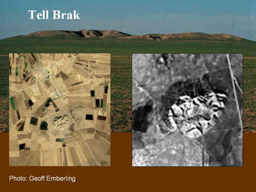
Tell Brak, Syria: in profile, and on satellite imagery (right, a CORONA image).
Tell Brak Links: Project site and Learning siteSee also Tell Brak in ArchAtlas Visualisation
The situation was further revolutionized in 2000, however, with the Shuttle Radar Topographic Mission (SRTM) undertaken by NASA. For the first time it became possible to interrogate a systematic set of data in the form of a digital elevation model (DEM) with sufficient resolution to record these artificial phenomena. In other words, tells (or at least the larger ones) suddenly became routinely visible from space! This realization was recorded in an article in Antiquity in 2004, marking a new phase in the investigation of this phenomenon.
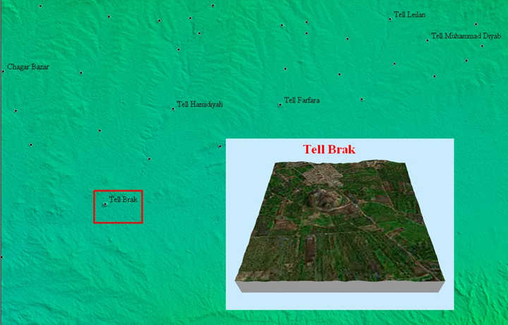
Tell Brak and its surroundings on the 90m SRTM digital elevation model (with tell-sites marked), and as a 3-D cutout with draped Landsat imagery.
What is this new information? During its eleven-day mission in February 2000, Space Shuttle Endeavour carried a specially-modified radar system which obtained elevation data for the greater part of the globe, capable of generating the most complete high-resolution digital topographic database of Earth. This SRTM data-set was collected at 1 arc-second resolution, the equivalent of 30m on the ground. For areas outside the US, this information has been sampled at 3 arc-seconds (which is 1/1200th of a degree of latitude and longitude, or about 90 meters) and made available in preliminary form. (It is hoped that the full-resolution data will ultimately be released.) Even at the 3 arc-seconds level of resolution, however, a multitude of early settlement-mounds are visible, and it became possible to form a preliminary picture of the distribution of these sites. The art of tellspotting was born.
Because settlement-mounds have characteristic sizes and shapes, and are generally situated in flat plains from which they stand out with particular clarity, the larger examples (particularly those of Bronze Age date) are relatively easy to spot by eye in areas where they are known to occur. (A more rigorous procedure will be described below.) These data make possible a whole range of archaeological investigations which are fundamental to our appreciation of ancient landscapes and their evolution. In the first place, they make it possible to provide accurate locational data for sites often poorly mapped, or described in the literature simply by distance from the nearest town. In the second place it becomes possible to prepare lists of potential sites in areas not yet subject to archaeological survey. Of course, such identifications can only be preliminary, and it is necessary to distinguish ancient settlement-mounds both from natural features (especially small volcanic phenomena) and more recent artificial accumulations. The combination of SRTM data with satellite imagery is an important step in doing this, but ultimately there is no substitute for "ground-truthing". Nevertheless the areas of intensive survey will always be limited, and by combining distribution-maps of known sites with identifications of tell sites, it is possible to gain a more complete impression of early settlement than ever before.
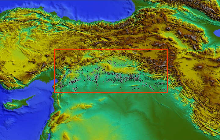
Location of the sample area, including parts of Turkey, Syria and Iraq, with the distribution of prominent tells visible on the SRTM digital elevation model.
Click on the red box for a more detailed map
To provide some idea of the scope of these data, the area between the north-east Mediterranean (Gulf of Iskenderun) and the middle Tigris (the heartland of ancient Assyria) has been rapidly scanned and prominent tell sites have been marked. This area represents the upper segment of the Fertile Crescent, the arc of fertile, rainfed land between the mountains and the steppes, where sedentary populations were concentrated. (This map thus represents a first approximation to a picture of relative population density over the entire area in later prehistoric and early historic times.) The identifications were made at a scale of approximately 1:50,000, the limit of resolution for the Landsat imagery. Only the most prominent and obvious mounds have been marked. Because the full file would be too large to upload, three sample areas have been selected (the Amuq, the upper Balikh and the eastern Jazira). For reproduction here, images at a scale of approximately 1:200,000 have been created, both as a simple SRTM terrain model, and as a Landsat 7 image draped over the terrain model (both preceded by a locator map at an intermediate scale). The full distribution-map is also provided, without the location-squares for the sample areas, in three forms: as a terrain model; as a flat Landsat image, and as a draped Landsat image. Follow the instructions to open new windows to see these images.
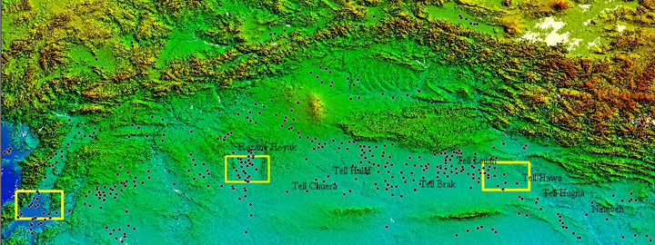
The sample area, with prominent mounds visible on the SRTM 90m terrain model interpreted as tell sites. Yellow squares indicate the areas illustrated at higher resolution .
Click on the yellow boxes to enter the areas
Not all sites (even large ones) appear on this image: note that more tells existed in the plains now drowned by large water-reservoirs created by damming the Euphrates and Tigris, and that they will not have been spotted in areas of undulating topography, even where they are known to exist (e.g. in the Malatya basin). Nevertheless the overall pattern is probably broadly representative, and shows such large, stable settlements as being typically located (often at considerable density) in the well watered sections of flat plains. Less permanent settlements undoubtedly existed contemporaneously, albeit at lower density, in the intervening areas. The clear correlation with topographic and vegetational conditions explains the discontinuous nature of the distribution, interrupted by areas of dry country or more rugged terrain. Both the vegetation and the terrain map are required to understand the distribution. This map is the beginning of the investigation, however, and not its end! (Here begins an entirely new science - as Virchow said of Schliemann's excavations at Troy.)
Rectangles not clickable
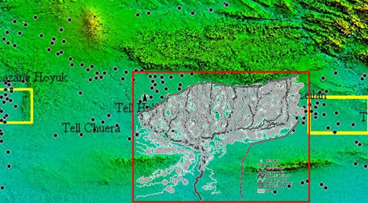
One of the most intensively studied segments of the northern Fertile Crescent is the Upper Khabur catchment in Syria (grey-shaded area within the red rectangle), demonstrated from satellite imagery to have been intensively settled in early historic times. This area is a test-bed of new techniques.
There is a more sophisticated way of finding tell-sites from digital elevation data and satellite images than simply eyeballing the pictures. This is to use computer-based pattern recognition procedures, and train the program on authenticated examples. Björn Menze, of the Interdisciplinary Centre for Scientific Computing at the University of Heidelberg, outlines his answer. This experiment uses a well-studied part of the region illustrated above, the Khabur basin (studied by Jason Ur), to illustrate the power of quantitative methods.

Click on the picture to see the presentation
SEE NOW THE FOLLOWING PUBLICATIONS
B.H. Menze , J.A. Ur , A.G. Sherratt Tell spotting: surveying Near Eastern settlement mounds from space
Paper delivered at the CIPA 2005, XX International Symposium (International Cooperation to Save the World´s Cultural Heritage) Torino, Italy, 26 September to 1 October 2005
Download as a pdf file from: http://cipa.icomos.org/fileadmin/papers/Torino2005/458.pdf
AND
B.H. Menze , J.A. Ur , A.G. Sherratt Detection of ancient settlement mounds – Archaeological survey based on the SRTM terrain model
To appear in the special issue of Photogrammetric Engineering and Remote Sensing devoted to documentation of the quality and characteristics of data from the Shuttle Radar Topography Mission, and to describe applications benefiting from the data, to be published in February 2006.