 Occasional Papers (2009-)
 Site Visualisations
THE GROWTH OF URBAN SUPPLY ROUTES 3500 BC - AD 1500
(Click here for a period-by-period manual sequence)
Plotted at 500-year intervals, the successive snapshots used in this animation show the proliferation of trade routes which supplied a growing urban network. Beginning with the earliest cities of Mesopotamia, in the fourth millennium BC, a cumulative process of expansion continued down to the present day. Growth was not even, either in space or time; the Persian Gulf network collapsed around 1700 BC, and there was general contraction at the end of the Bronze Age, in the late second millennium BC – followed by very rapid expansion in the early first millennium BC, at the beginning of the Iron Age. Interaction with China, already evident in AD 1, shifted the centre of gravity to the Indian Ocean; until discovery of the New World brought a new importance to the Atlantic coastlands. This sequence, schematic though it is, demonstrates the cumulative growth of urban system and the proliferation of trade routes associated with it.
THE IMPORTANCE OF TRADE
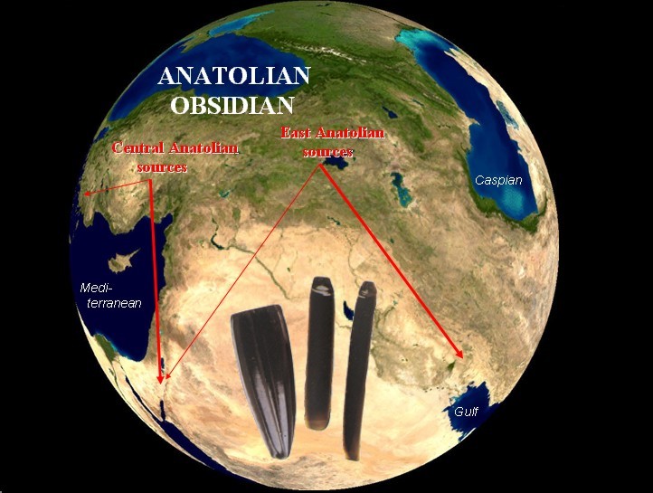
Amongst the earliest farming communities of western Asia (9000-6000 BC), and even earlier, the natural black glass called obsidian, used for exceptionally sharp and impressive blades, was traded in small quantities up to 1000 km away from its sources in the volcanic mountain rim of the Fertile Crescent. Its areas of origin can be identified by characteristic impurity patterns. It was distributed in a multitude of individual transactions, probably in the form of gift-exchange between neighbouring communities, along the major axes of contact, down the Levant and around the rim of the Fertile Crescent. Many other valued materials (including organics such as plant-products used as medicines and drugs) probably circulated along the same routes, but survive less well archaeologically. Certain communities, advantageously placed within the network of connections (such as Bouqras on the Euphrates), obtained particular benefit and developed to a larger size than their contemporaries. These "nodal" settlements, not yet urban in the sense of having centralised organisation and advanced craft skills or extensive manufacturing activity, nevertheless demonstrate the potential for trading activity in the Fertile Crescent, with its sharply contrasting landscapes and complementary resources. (Original work by Renfrew, Cann and Dixon, 1968).
See also The Obsidian trade
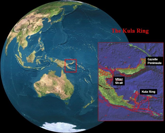
Insight into the nature of early trafficking in material items ("trade" in its broadest sense) is provided by ethnographic descriptions of exchange-cycles in areas such as Melanesia. These circulate prestige items such as Spondylus shell bracelets between trading-partners, but are also the mechanism for distributing more everyday items including both foodstuffs and durable goods such as pottery. These coastal trading networks have been intensively studied by ethnographers, including Malinowski's classic work on the Kula Ring, and later work on the Siassi of the Vitiaz Strait. They provide analogies for the kinds of exchange-networks that must have criss-crossed most of the world before the intrusion of urban-centred trading systems, and have survived here until recent times because (unlike the Moluccan Spice Islands, at the opposite end of New Guinea), they provided no precious materials of interest to the world outside (Routes after Brookfield and Hart).
The Lapis Lazuli route: a long-distance supply-chain at the time of the first cities
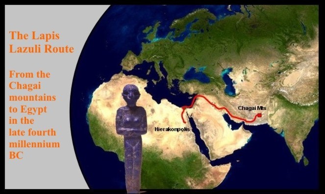
Lapis lazuli figurine, Hierakonpolis, Egypt, c. 3000 BC. (Photo: Ashmolean Museum)
By the time of the emergence of the first cities, in late-fourth millennium Mesopotamia, there was sufficient demand for high-value materials to move certain precious materials over impressive distances. Lapis lazuli (lazurite) is a rare mineral formed under unusual geological conditions, and restricted to certain sources on the western margins of the Himalayas (and otherwise in Siberia, the Andes, and the western USA). Its intense ("azure") blue colour made it especially desirable for aesthetic and religious reasons (in medieval Europe it was used in painting the clothing of the Virgin Mary). Probably obtained initially from sources in the Chagai mountains, it was traded 2000 km to lowland Mesopotamia by the fourth millennium BC; and in the second half of the millennium small quantities reached Egypt, a further 2000 km away, where it was sometimes carved into locally meaningful forms, as with the figurine shown above. (During the third millennium, new sources of lazurite were opened up in Badakhshan, ancient Bactria.) This distribution-area indicates the size of the catchment from which early urban communities obtained precious materials, including also silver and gold. Most of this movement of materials was achieved by indirect transfer in a multitude of individual transactions, much as silk was moved across the entire width of Eurasia in late Roman and early Medieval times. Indeed, the Lapis Lazuli route, and the Chinese Jade Route from Sinkiang, were the precursors of this later transcontinental connection.
Bronze Age Europe: an early urban hinterland

By 2000 BC, urban life had spread from Mesopotamia into the eastern Mediterranean, including parts of present-day Turkey and Greece. The greater material wealth of urban communities, with their specialised manufacturing and bulk transport of commodities, allowed them to pull in high-value resources from surrounding territories, by tapping in to local exchange-cycles. The Black Sea coastlands and the Danube valley were drawn into indirect contact through centres such as Troy, and long-distance relay routes reached as far as the Baltic, bringing small quantities of materials such as amber. These tentative links to the European hinterland initiated important changes, including the transfer of technology (metalworking techniques and military innovations such as metal spearheads and two-wheeled fighting-vehicles, as well as clothing and ornament styles). Yet "barbarian" Europeans were not simply passive recipients of these new features; they created new forms of society, often dominated by military elites, and themselves pioneered improvements in technique, such as the development of the horse-drawn chariot on the steppes north of the Black Sea, and hollow-cast bronze spearheads. The map of Bronze Age Europe (inset, from Sherratt 1998) shows a range of trade-routes extending from "inter-city" routes of bulk traffic in the eastern Mediterranean to "relay-routes" between powerful local chieftains in the continental hinterland.
Urbanisation in the Roman Empire: a politically integrated economy
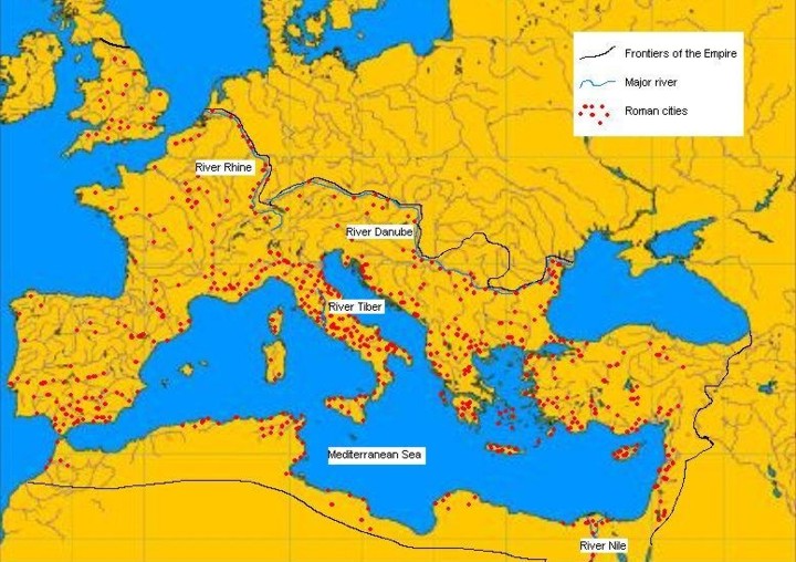
Map by Joy Margerum, from Cornell and Matthews after Pounds
By the end of the first millennium BC, urban systems had spread along the whole length of the Mediterranean, and the basin had been integrated into a single political entity, the Roman Empire. This came to encompass not just the coastlands but the also area of temperate Europe north of the Alps which was accessible by river-connections. Nevertheless the distribution of urban settlements continued to be clustered in a few major heartlands around the Mediterranean, with towns in temperate Europe situated especially on major rivers. In addition, frontier areas with army garrisons were supported by taxation of the empire as a whole. Rome itself was supplied by sea with grain from Egypt and north Africa, wine from the Aegean, and with olive oil and fish-products from Iberia. Most of these were moved in bulk on pottery containers (amphorae). The era of Roman domination represents an unusual period in the spread of urban systems, when a large part of the urbanised world and its immediate supply-area was politically unified. High-value items continued to be supplied from beyond this area, such as amber from the North, spices, precious stones and luxury textiles from the East. The areas immediately outside the Empire in northern Europe supplied both hides, clothing items, and wheeled vehicles. These Germanic-speaking northern neighbours were to take over much of the western part of the Empire, when the economic focus shifted eastwards, and its political integrity collapsed in the fourth century AD. (Note that contemporary urban settlement in western Asia, under the Parthian Empire, is not shown here.)
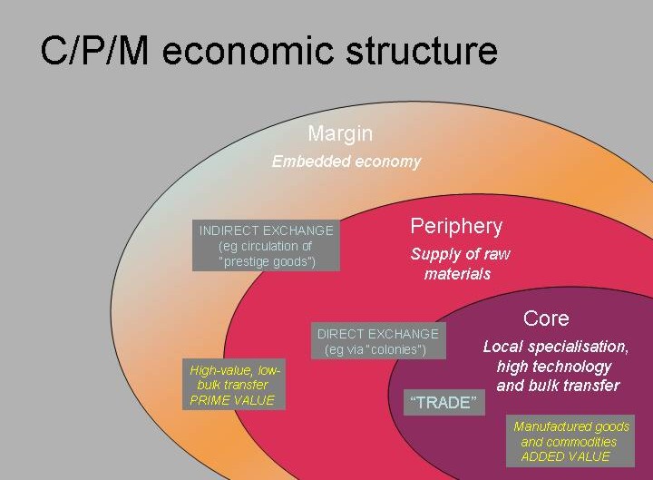
The zonation of a world system
It is convenient to summarise the different kinds of economic activity and trading relationships described in the above examples in terms of some broad contrasts. After the genesis of urban systems in fourth-millennium Mesopotamia, the surrounding landmass came to be zonally differentiated in relation to the expanding urban communities. Nearby areas were fundamentally transformed by the kinds of activities taking place in the urban heartlands, and more distant regions were only indirectly affected. We may recognise the nature of these differences by regarding the urban heartlands themselves as the core of the system, the surrounding areas which supplied raw materials as their periphery, and the area only indirectly affected (by the spread of technologies, or the provision of small quantities of precious materials) as the margin. Together, these interacting elements make up what historians have come to describe as a world system: an inter-connected set of relationships whose components cannot be understood in isolation from the whole. The zonal labels are not absolute categories, but provide a framework for interpretation – systematising observable contrasts, rather than imposing an abstract theory. As the map of the Roman Empire shows, political entities may encompass both core and peripheral areas; indeed, the notion of "core" and "periphery" operates on several spatial scales, nested in a complex fractal relationship.
These kinds of distinction were first elaborated by historians dealing with the colonial expansion of European populations around the world from the sixteenth century onwards, when military superiority allowed native populations to be exploited and made these regions dependent on the imperial powers or their former colonial offshoots - a situation of relative under-development which has persisted into the post-colonial era. Such stark contrasts rarely obtained in earlier times, and more basic definitions are preferable, which could apply to a wider range of periods and circumstances. The description offered here is an attempt to provide such a formulation.
CORE: The urban area at the centre is characterised by bulk transfer of products, with manufacturing processes in specialised units on a scale which requires the concentration of materials, and the co-ordination of different groups in the cycle of production, distribution and consumption. Those who produce the goods are not necessarily those who will consume them. These long chains of relationships go beyond forms of organisation based on family and kinship.
PERIPHERY: This zone is still characterised by forms of production in which kin groups are important, but the system is geared to produce a surplus of raw materials for export, in return for the kinds of manufactured goods which cannot be produced locally. This export (and the import of desirable commodities) is typically organised by an elite who monopolise the benefits of such external exchange. Facilities are often defended, hence the occurrence of "hillforts" as characteristic types of site. This peripheral status is often a transitional one, as more advanced production techniques can be acquired to substitute locally-made products for expensive imports, and the area may join the wider network of urban communities. Polities within the core may resist this process, and attempt to incorporate the area into a system of territorial control, thereby prolonging its dependency on core facilities; otherwise, the area may achieve political independence and itself take on the characteristics of the core.
MARGIN: Although altered by the spread of technologies initiated in the core, the margin is not directly articulated with it by regular economic exchanges. Hence its structure is not fundamentally affected by the need to produce a surplus for export, although (where they occur) some valuable materials may be mobilised for transmission to consumers elsewhere. There may nevertheless be considerable diversity in the products which circulate within local networks, and a degree of social differentiation as a result of such internal exchanges. Most of these will be organised in units based on kinship, where social obligations are of fundamental importance.
The contrasts from the outer to the inner parts of the system can be summarised as a progressive disembedding of material transactions from kinship ties, as relationships become more indirect and with many steps within the chains linking production to consumption. The scale on which activities are organised progressively increases, as does the variety and organic interdependence of the constituent parts. Since flows of materials unite groups at very different levels of social and political organisation, particular features are found at the borders of zones: in particular, the core may articulate with its periphery by means of specialised trading settlements or "colonies", which may become unnecessary when a further degree of integration has been achieved.
This description does not imply any simple ideological or cultural dependence between the different zones, or any degree of cultural homogenisation; although certain values and consumption practices (e.g. wine-drinking) may spread along routes of contact (and, later on, many world-religions have spread in this way), these are often locally re-interpreted and may be used to construct alternative world-views and cultural patterns. Far from representing a passive "diffusion" of culture, these dialectical encounters have often magnified cultural contrasts – much as today's globalisation is accompanied by renewed nationalism and an emphasis on local roots and origins.
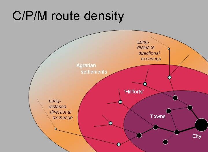
This series of spatial contrasts may be summarised in diagrammatic form in the following series of models, respectively presenting the role of the different zones, their typical settlement patterns and routes, and the social and economic structures which underlie them.

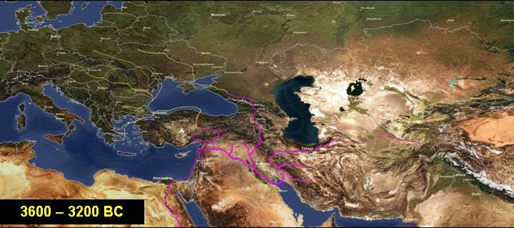
The West-Eurasia World System, 3600-1400 BC
To bring these ideas and observations together, an animated sequence of maps shows the growth of trade routes for the first two millennia following the genesis of urban life. Plotted in blocks of 400 years, the maps in this animation show in greater detail the reconstructed trade-routes which linked the various urban heartlands of western Eurasia both with each other (within the core zone), with their peripheries, and with long-distance routes reaching into surrounding marginal area. Magenta lines indicate regular flows of products (manufactured goods and raw materials) between urban centres and their immediate supply zone. Yellow lines indicate, in more schematic form, the principal orientations of long-distance contacts within the margin. (These would be more realistically represented by braided strands, rather than as formal routes, since they indicate shifting alliances between unstable political groupings linking local exchange-cycles into temporary configurations related to the opportunities presented by evolving urban networks.)
These maps are a tentative reconstruction, already partly outdated by better information, of the rapidly-changing patterns of contact and trade within a growing system. Like the global maps at the beginning of this section, they are offered because they convey something of the dynamic nature of the process they represent, and are a notable improvement on the partial snapshots usually provided as representations of "Bronze Age trade". (Click to access pdf file - "Small Worlds")
THE BRONZE AGE WORLD SYSTEM OF WESTERN EURASIA, 3600-1400 BC
(Click on the image for the complete animated sequence)
(Click here for period-by-period manual sequence)
The rich mineral resources of the highland rim of the Fertile Crescent were a latent precondition for the formation of a complex trading system: a "periphery" waiting for a "core". The growth of temple-centres in the unusual conditions of lowland Mesopotamia and southwest Iran, with their relatively dense concentrations of farming population supported by irrigation agriculture, created an organised body of potential consumers in the middle of a network of contacts reaching into the surrounding highlands. The Tigris and Euphrates provided arteries of transport as well as water for irrigation. During the fourth millennium the combination of a powerful ideology with a labour-force capable of manufacturing textiles, milk-products and alcoholic drinks from their domesticated plants and livestock, provided the basis for a process of expansion which mobilised the products of surrounding areas and initiated an explosive process of urban growth in the later fourth millennium BC. In the second half of the millennium, colonial settlements were founded at nodal points in upper Mesopotamia, giving access to Anatolia, the Caucasus, and the Levant. Coastal connections brought this growing network into contact with Egypt, stimulating a period of accelerated changes and the formation of a second "alluvial civilisation" along the Nile.
After 3200 BC there was a notable expansion on the Persian plateau, and an extension of contacts down the Gulf. The "colonial" enterprise in the north was replaced by an expansion of indigenous trading networks, which reached beyond Anatolia to the steppes and the Aegean. Egyptians founded their own colonial settlements in the southern Levant. Then, towards the end of the third millennium, the Indus valley joined the trio of "alluvial civilisations", and much of the traffic formerly crossing the Persian plateau was carried down the Indus and along the Gulf (including lazurite from new sources in Badakhshan, initially tapped by Indus colonies.) After 2000 BC there was a major expansion of population and trading activity on the steppes and the Danube corridor, partly stimulated by the spread of new metalworking technologies in the outer hinterlands of the urban core region. After 1700 BC, the Indus valley and the Gulf network collapsed, while expansion in the east Mediterranean continued. Between 1600 and 1400 BC a major maritime trading network developed, integrating the coastlands from Egypt and the Levant to Anatolia and the Aegean, where large sailing-ships plied a circular route. Links to Italy stimulated the formation of contacts across the Alps, and the formation of a new Amber route which replaced the earlier Danube axis. Latitudinal routes across the steppes continued to extend, bringing wheeled vehicles to China (hitherto ignorant of the wheel) in the late Shang period.
This brief summary ends with the climax of Bronze Age development, before the radical changes which took place at the end of the second millennium, leading to widespread retraction and reorganisation, and also to the development and spread of ironworking. The larger scale of demographic growth and urban development in the first millennium BC, which saw expansion both in the Mediterranean basin and the Ganges valley and in the intervening area where the first large land-empires developed, demands a larger scale of treatment which is impossible here. Nevertheless the systematic mapping of urban centres and trade networks is as illuminating for this larger world as it is for the early stages of urban expansion represented here.