 Occasional Papers (2009-)
 Site Visualisations
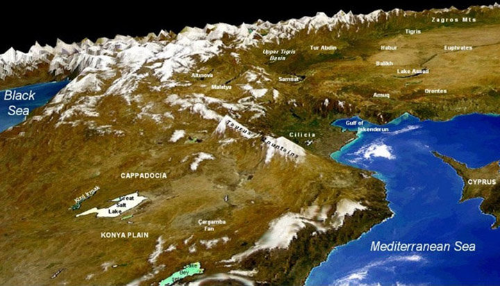
NASA/GSFC: OrbView-2SeaWiFS 1 km DEM
Just as electronic cartography allows us to animate a sequence of maps, moving through time, so it allows us to view a point from many angles, moving through space - just as we do in walking or flying through a landscape. This allows a 3-dimensional appreciation of the position of a site and its significance. As more precise digital elevation models become available, matching the resolution of satellite imagery, these virtual models will become increasingly useful, rendering the art of map-reading (the imaginative reconstruction of 3-dimensional reality from a 2-dimensional paper representation) largely unnecessary.
VRML (Virtual Reality Modelling Language) is a standard language for interactive simulation within the World Wide Web. It has here been used to allow the viewer to interact with 3D geographical maps. One can walk or fly through the landscape with the possibility of examining it in detail. (You may also wish to compare these with Virtual Globes , an alternative means to view geographic data in 3 dimensions).
VRMLs are simple to use and commands can be given by either the computer mouse, or the keyboard. In order to view the following VRMLs, you will need to install a VRML-capable viewer. There are many different viewers available, for different platforms, including several plugins which will allow you to view the files within your web browser.
Getting started!1. Install a VRML viewer. For a good list of viewers please see: Note: we've tested these VRMLs with Blaxxun Contact for Windows (Manual) , and Cortona for Mac OS X. 2. Select a VRML landscape below (click on the icon). Please note that some of these VRMLs contain high resolution imagery and so may be slow to load or manipulate. 3. Use the viewer-specific controls to navigate or manipulate the view. |
Controls - Blaxxun Contact for Windows:Click Zoom: (Ctrl+Shift+F) then hold down the left-click on the mouse and move it forward (zoom in) and backward (zoom out) Rotate: (Ctrl+Shift+E) then hold down the left-click on the mouse and move it around to rotate the 3D image Use the mouse: right-click and choose Movement ► Examine or Fly |
Controls - Cortona for Mac OS X:Use the mouse: the left hand toolbox allows you to select the Examine, Fly modes |
SITES and LANDSCAPES
(Click on the thumbnail to access the VRML)
THESE ARE LARGE FILES: PLEASE BE PATIENT WHILE THEY LOAD!
 Konya Plain (including Çatalhöyük)
(See
also: Çatalhöyük from space)
Konya Plain (including Çatalhöyük)
(See
also: Çatalhöyük from space) |
 Thessaly (including Argissa) (See
also: Argissa from space) Thessaly (including Argissa) (See
also: Argissa from space) |
 Susa (See
also: Susa from space)
Susa (See
also: Susa from space) |
 Kerkenes (See
also: Kerkenes from space)
Kerkenes (See
also: Kerkenes from space) |
 Mycenae (See
also: Mycenae from space)
Mycenae (See
also: Mycenae from space) |