Important news about the threat to the Dept of Archaeology at the University of Sheffield... Read more...

Steps Toward the Study of Seasonality and Trade

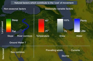
For the most part, the study of large-scale trade and exchange in the ancient world remains distanced from the physical hardships of real human travel. Ancient trade or, more neutrally, ancient ‘interaction’ is often discussed as if it took place between actors who inhabited a flat and unchanging spatial surface. In fact, topography, climate and seasonality are essential to understanding the changing forms and intensity of human travel that enabled ‘interdependence’ between communities of the Near East. This paper demonstrates some of the steps needed to reintegrate seasonality with the study of ancient trade.

Geospatial Analysis of Aguadas

Water has been a principal concern for Maya people inhabiting much of the Yucatan Peninsula for millennia. As a result, studies of water management in the Maya region contribute significantly to our understanding of ancient Maya civilization and its environmental adaptations. Aguadas, water storage ponds of varying size, have been an understudied aspect of Maya water management systems. Recognizing the origins and functions of aguadas provides a more complete picture of ancient Maya water management strategies. In this study, we analyze aguadas geovisually and geospatially in the southern Maya lowlands.

Networks of interaction in Early Bronze Age Anatolia

Research carried out in Turkey over the last few decades seems to indicate that the Early Bronze Age in west and central Anatolia was a period in which new socio-political structures emerged whose mature development is reflected in the territorial entities of the Old Assyrian period. From the second half of the third millennium, we have evidence of social stratification both at the intra-site and inter-site level, accompanied by a wealth of prestige goods and public structures displayed in settlement and funerary contexts. This phenomenon is also paralleled by the rapid growth of long-distance relations both within Anatolia and with surrounding regions, at least partially triggered by the rise in metal demand of local and foreign elites.

Mapping the Silk Road

Little was known of the remarkable heritage of the Silk Road until explorers and archaeologists of the early twentieth century uncovered the ruins of ancient cities in the desert sands, revealing astonishing sculptures, murals and manuscripts. One of the most notable discoveries was the Buddhist cave library near the oasis town of Dunhuang on the edge of the Gobi desert in western China. The cave had been sealed and hidden at the end of the first millennium AD and only re-discovered in 1900. Forty thousand manuscripts, paintings and printed documents on paper and silk were found in the cave itself. Tens of thousands more items were excavated from other Silk Road archaeological sites. These unique items have fascinating stories to tell of life on this great trade route from 100 BC to AD 1400. Yet most were dispersed to institutions worldwide in the early 1900s, making access difficult. The size and scope of the collections, as well as their fragility and limited access, has meant that, while they constitute a primary research resource for the history and literature of the region, many of the manuscripts in particular have yet to be studied in detail. The International Dunhuang Project aims to reunite this material by making it freely available online. One part of this project includes the mapping of archaeological sites, and the digitisation of data from archaeological data collected by Aurel Stein and other researchers, using tools such as Google Earth to help users to better understand the history of the Tarim Basin and its cultures.
Trade networks in the Karakum

In our imagination of the 'Silk Routes', we envisage travellers, traders and intellectuals traversing vast continents for the purpose of exchanging rare and precious items. The archaeological study of these routes has usually focused on transmitted artefacts and ideas, as opposed to the means and methods by which they were carried. The resultant void of knowledge concerning the infrastructure of the Silk Roads, and the nature of the settlements that shaped and were shaped by them, presents a challenge to archaeologists from both a methodological and theoretical perspective.

Levant Harbour Towns in the Middle Bronze Age

Trading connections and routes play a very important part in the development (or re-development) of urban centres in the Middle Bronze Age Levant. This is particularly clear in the regions of Cilicia and the Amuq Plain in the Hatay, in the north-east corner of the East Mediterranean, where at the beginning of the Middle Bronze Age we have evidence of large-scale public buildings and fortification systems which represent the revival of complex political and economic structures, following a collapse at the end of the Early Bronze Age. A key role in this is played by harbour towns on the Cilician and Levantine coasts, which have an important part in the articulation and exploitation of maritime and inland routes connecting different zones and their resources. This in turn leads, by the beginning of the Late Bronze Age, to the formation of a symbiotic network of semi-dependent kingdoms which link these different inland and coastal zones in a single interactive socio-economic system.

Roads and caravanserais in Medieval Syria

New research is currently being carried out in order to collect supplementary data, both historical and archaeological, on the road networks of Medieval Bilād al-Šām and their related facilities. Supported by the material evidence of caravanserais, the aim of the research is to propose a reconstruction and a preliminary analysis of the region's communication axis from the beginning of the Ayyubid period till the end of the Mamluk. The preliminary character of the reflections offered in this article will hopefully be pursued more thoroughly in the completion of a larger project now in its final phase.

Pathways and Highways

This visual essay explores the possibility of delineating two different types of routes, 'pathways' and 'highways', and the extent to which archaeology can help to analyse them. The technologies of cost-raster GIS analysis are introduced and applied to two case studies in Eastern Anatolia and Western Central Asia, c. 3000-1000 BC. It is to be hoped that the highlighted patterns, combined with a knowledge of contemporary material transformations, will provide insights into the processes of socio-economic change across these reconstructed networks of interaction.

Introduction to Remote Sensing data for Global Archaeology

This document briefly introduces some of the key sources of spatial data from remote sensing sources, and a few other data types which have been particularly useful for archaeological research, and in particular, in the construction of .

Ancient Near Eastern Route Systems: From the Ground Up

A particularly common trace of ancient route systems on the ground is the 'hollow way'. In the Middle East hollow ways, like their counterparts in the UK and Europe, appear as long, usually straight valleys. This paper examines the traces of these ancient route systems in the Ancient Near East according to their pattern, processes of formation, parallels elsewhere, and their function.

Unscrambling the 'Uplands'

This presentation forms part of a a collaborative British-Syrian project called Settlement and Landscape Development in the Homs Region, Syria, that seeks to compare human activity in adjacent but contrasting landscapes in a typical part of western Syria. In this case we focus on an upland landscape, where stone architecture is the expectation. In the traditional literature, most discussion of such areas has concentrated upon the evidence for activity of Graeco-Roman date - the Dead Cities of the Limestone Massif on north-western Syria are an excellent example. However, we have very little knowledge of the evidence for earlier periods. This is, we suspect, because we have little idea of what we should be looking for.

Remote Sensing in Inaccessible Lands

The current political situation in many areas of Western and Central Asia makes effective ground based archaeological research virtually impossible. Whilst people are generally cognisant of the situation in Iraq, this is also true for Afghanistan and parts of Pakistan. Furthermore, since the mid-19th century, the mountainous regions that comprise the eastern borderlands of modern Afghanistan, along with the western parts of the North West Frontier Province (NWFP) and the Tribal Areas of modern Pakistan have been difficult to access for extended periods. However, with the widespread availability of free or inexpensive satellite imagery, it is now possible to 'visit' these regions by looking at them from space. The use of satellite imagery in this way has a number of specific archaeological applications, including the reconstruction of ancient routes, the remote detection of archaeological sites and the assessment of site destruction and looting.

Agricultural and Pastoral Landscapes in the Near East

The Near East presents particular challenges to the study of past landscapes. Remote sensing has been a part of archaeology for a century, and aerial photographic coverage is now the ideal and standard for field survey basemaps. Such coverge, however, is not globally available. In the modern Middle East, for example, easy access to aerial photography is often impossible to obtain. As a result, archaeologists have turned to satellite imagery. Unfortunately, the resolution of space-based imaging systems such as Landsat and SPOT is often too coarse for archaeological features. To some extent, this issue has been solved by the availability of commercial high-resolution imagery. However, such imagery is expensive and documents the modern developed landscape. Over the last decade, Near Eastern archaeologists employed a new satellite resource that resolves many of these issues: the declassified CORONA intelligence program.

Mat Ashur - Land of Ashur

This paper gives an introduction to the archaeology of the Assyrian heartland where only a limited investigation outside of the big centres has taken place in the field. With methods of landscape archaeology and remote sensing techniques it is possible to survey a wide area and integrate detected landscape features into an historical framework and social and chronological contexts.

Quantitative approaches to the remote sensing of ancient settlements

Tells, the characteristic settlement mounds of the Near East, are visible remains of the first human settlement system. Often piled up to considerable heights by the debris of millennia of settlement activity, they provide characteristic physical signatures, such as specific elevation profiles or soil changes, which – potentially – can be detected in data available from space-borne sensors. Using methods from pattern recognition and statistical learning, we systematically evaluated digital elevation models and multispectral imagery to provide means for a machine based detection and mapping of these archaeologically relevant settlement sites.

Virtual globes, geotagging and global landscapes

This paper raises a series of broad issues about a particular set of new technologies which have become available for Mapping Human History from Space, namely: virtual globes, such as Google Earth and NASA's WorldWind, and their relationship to online archaeological datasets. First, some of technical background to these visualisation programs is explained, especially how they stand in relationship to previous GIS approaches. Issues with the increasing trend within archaeology, to publish site locations and other archaeological information using online databases are raised; and the possibilities and problems for a global archaeological atlas and the integration of multiple databases are explored. Finally the paper touches on the possible future research applications of initiatives which use novel visualisation and integrative databases.

Tellspotting

How do we know where sites are? In the arc from south-east Europe to north-west India, early farming sites often form prominent mounds (known from the Arabic term as tell settlements). Such sites were often occupied over many millennia, and some of them grew into major cities during the Bronze Age; though thereafter settlement tended to shift to new locations away from the mounds. These early settlement-mounds form characteristic features of the landscape, and in fact are visible from space. Release of data from the Shuttle Radar Topography Mission in 2000 has provided the opportunity to identify the positions of many known archaeological sites of this type and to recognise others. Tellspotting is now not only an agreeable hobby, but has a high-tech methodology: an invaluable tool in reconstructing settlement-history and a means of inventorizing these outstanding sources of archaeological information.

The Obsidian Trade in the Near East, 14,000 to 6500 BC

Obsidian, a black volcanic glass, was first recognized by Colin Renfrew and his colleagues J.E. Dixon and J.R. Cann in the 1960s as a uniquely sensitive indicator of prehistoric trade, both because of the great desirability of this material before the use of metals, and also because the trace-elements it contains are usually diagnostic of individual sources. Based on data extracted from M.-C. Cauvin et al., L'obsidienne au Proche et Moyen Orient: du volcan à l'outil (Oxford: BAR Int. Ser. 738), maps indicate the flows of material from two major source-areas.

Culture Areas in Western Eurasia 20,000-3250BC

Prehistoric archaeologists have some weird labels for their material, naming cultural groups after the sites where they were first recognised, or after their most characteristic artefacts. These make a whole lot more sense when plotted on maps, period by period, so that patterns of cultural similarity, and connection become apparent. Do 'cultures' exist? I don't know, but if archaeologists use them in their everyday work, it makes sense to know where they are, or are thought to be.

Virtual Survey: a semi-automated tellspotting algorithm

Following the observation that prehistoric and early historic settlement-mounds (tell settlements) in parts of the Near and Middle East can be recognized in the SRTM 90m terrain model (Sherratt, Antiquity 2004) an algorithm has been developed to do this automatically, using current techniques of computer modeling.

Portages

Early trading networks carried relatively small quantities of valuable goods, often over considerable distances, both by land and water. The relationship between overland transport and carriage by river or sea helps to explain why trading centres rose to prominence at certain key positions on these routes. With very small quantities of goods, light vessels might be carried over short distances between rivers; and even when the bulk of traded goods increased, it might still be advantageous to carry the goods for short distances overland from one port to another. Sites at such break-of-bulk points became major nodes in the transport network. This presentation explores the changing geometry of early trade-routes, and especially the interface between land and sea.

Exploring Routes and Plains in Southwest Iran

Satellite imaging has given a new dimension to fieldwork in the varied terrain of Southwestern Iran, where the Zagros mountains separate the Mesopotamian lowlands from highland Iran, and whose successive ridges enclose fertile intermontane valleys. These fertile enclaves were often settled as early as the Neolithic, and have a continuous history of occupation down to the present day. They gained a historical importance as stepping stones on routes through the mountains (both for transhumance and trade), and as nodal points in the formation of political units.

The Origins of Farming in South-West Asia

Satellite images provide a convenient means of understanding why early sites were chosen for settlement, and of visualising the routes that linked them. These two factors (location amongst critical resources, and position in wider networks) interacted with each other: oases were occupied both because of their local advantages, and also because they acted as stepping-stones on routes carrying desirable materials over long distances. This presentation applies these arguments to a critical problem in prehistoric archaeology: where precisely did farming first emerge in western Asia?

Contagious Processes

Archaeologists have long recognised (though in practice tend to forget) the degree to which developments in one part of the world were affected by things happening elsewhere. These animated maps of the spread of farming and of urbanism are intended to show a fundamental aspect of long-term human history: the underlying patterns of concentric expansion which have characterised cultural change in the Holocene.

Sites and Landscapes in 3D

If we have elevation data (conventionally represented by contour-lines) and satellite imagery, why not combine the two? This allows a site to be represented not just in a vertical view, but as it is seen from different viewpoints. Why not combine them all, so that it can be examined from all angles, flown over, walked through? These are some examples of famous areas and sites. A hint of the future, when such representations will be routine.

Panoramas

The resolution of satellite-imagery in the public domain is constantly improving. Although images with the resolution hitherto obtainable by aerial photographs are still expensive, imagery with a resolution of 15m or better is routinely available for most parts of the world, thanks principally to NASA. For some areas, this is already better than most maps. It is especially useful in areas with strong vegetational contrasts depending on water-sources. Selected key sites are presented here, as they can be seen from space.

East-West Contacts in Eurasia

Connections between the eastern and western ends of Eurasia began in the Bronze Age: China and the West co-evolved. A global viewpoint shows how this happened, first across the forests of Siberia, then by the steppes and oases of the Silk Road, then increasingly by sea, via the Indian Ocean. This is a human story of cultural encounter, exchange and creativity – and, ultimately, geo-economics.

Trade Routes: Growth of Global Trade

One of the most evident features of the human past is the growing scale of connections between areas, shown for instance by the movement of materials (such as the Obsidian Trade). Although the current phase of "globalisation" is unique in its range and impact, it was preceded by many earlier episodes of expansion and collapse. These maps reconstruct how such networks develop, and show how they follow a logic reflecting both their own geometry and that of the Earth's surface, and how they sometimes come to a catastrophic stop.

Why an electronic atlas of archaeology?

When astronauts first took photographs of Earth from space, it transformed traditional images of the planet. Here, for the first time, were photographs of the world as it actually is. Systematic use of this information was at first confined to military objectives, but nowadays these images are familiar, as the backdrop to news items and weather forecasts. Moreover, they are now available as continuous cover, and can themselves be used as maps. began in Oxford in 2000, as a means of making available the kinds of images and interpretations which are more easily disseminated through a website than by conventional paper publication.

Environmental Change: The evolution of Mesopotamia

The areas that were occupied by early farmers and town-dwellers were often very different from the landscapes that can be seen in the same areas today. Some of the most important changes took place in the great river basins where urban civilisation first emerged. Southern Mesopotamia (Iraq), the land of the two rivers, has been transformed over the last six thousand years by the changing relationships between rivers, land and sea. Although the pattern has not yet been reconstructed in detail, satellite imagery can be used to outline the major processes of change, and to visualise what an extraordinary landscape this was at the time of the first cities.

Global View: A framework for expansion

How to organise a global view of archaeology? The aim of this website is to provide maps and imagery which complement our understanding of the ancient world, and suggest new approaches to it...

Sites from Satellites

The resolution of satellite-imagery in the public domain is constantly improving. Although images with the resolution hitherto obtainable by aerial photographs are still expensive, imagery with a resolution of 15m or better is routinely available for most parts of the world, thanks principally to NASA. For some areas, this is already better than most maps. It is especially useful in areas with strong vegetational contrasts depending on water-sources. Selected key sites are presented here, as they can be seen from space.