Important news about the threat to the Dept of Archaeology at the University of Sheffield... Read more...

Steps Toward the Study of Seasonality and Trade
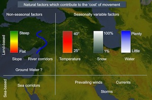
For the most part, the study of large-scale trade and exchange in the ancient world remains distanced from the physical hardships of real human travel. Ancient trade or, more neutrally, ancient ‘interaction’ is often discussed as if it took place between actors who inhabited a flat and unchanging spatial surface. In fact, topography, climate and seasonality are essential to understanding the changing forms and intensity of human travel that enabled ‘interdependence’ between communities of the Near East. This paper demonstrates some of the steps needed to reintegrate seasonality with the study of ancient trade.

Geospatial Analysis of Aguadas

Water has been a principal concern for Maya people inhabiting much of the Yucatan Peninsula for millennia. As a result, studies of water management in the Maya region contribute significantly to our understanding of ancient Maya civilization and its environmental adaptations. Aguadas, water storage ponds of varying size, have been an understudied aspect of Maya water management systems. Recognizing the origins and functions of aguadas provides a more complete picture of ancient Maya water management strategies. In this study, we analyze aguadas geovisually and geospatially in the southern Maya lowlands.

Agricultural and Pastoral Landscapes in the Near East

The Near East presents particular challenges to the study of past landscapes. Remote sensing has been a part of archaeology for a century, and aerial photographic coverage is now the ideal and standard for field survey basemaps. Such coverge, however, is not globally available. In the modern Middle East, for example, easy access to aerial photography is often impossible to obtain. As a result, archaeologists have turned to satellite imagery. Unfortunately, the resolution of space-based imaging systems such as Landsat and SPOT is often too coarse for archaeological features. To some extent, this issue has been solved by the availability of commercial high-resolution imagery. However, such imagery is expensive and documents the modern developed landscape. Over the last decade, Near Eastern archaeologists employed a new satellite resource that resolves many of these issues: the declassified CORONA intelligence program.

Contagious Processes

Archaeologists have long recognised (though in practice tend to forget) the degree to which developments in one part of the world were affected by things happening elsewhere. These animated maps of the spread of farming and of urbanism are intended to show a fundamental aspect of long-term human history: the underlying patterns of concentric expansion which have characterised cultural change in the Holocene.

The Origins of Farming in South-West Asia

Satellite images provide a convenient means of understanding why early sites were chosen for settlement, and of visualising the routes that linked them. These two factors (location amongst critical resources, and position in wider networks) interacted with each other: oases were occupied both because of their local advantages, and also because they acted as stepping-stones on routes carrying desirable materials over long distances. This presentation applies these arguments to a critical problem in prehistoric archaeology: where precisely did farming first emerge in western Asia?