 Occasional Papers (2009-)
 Site Visualisations
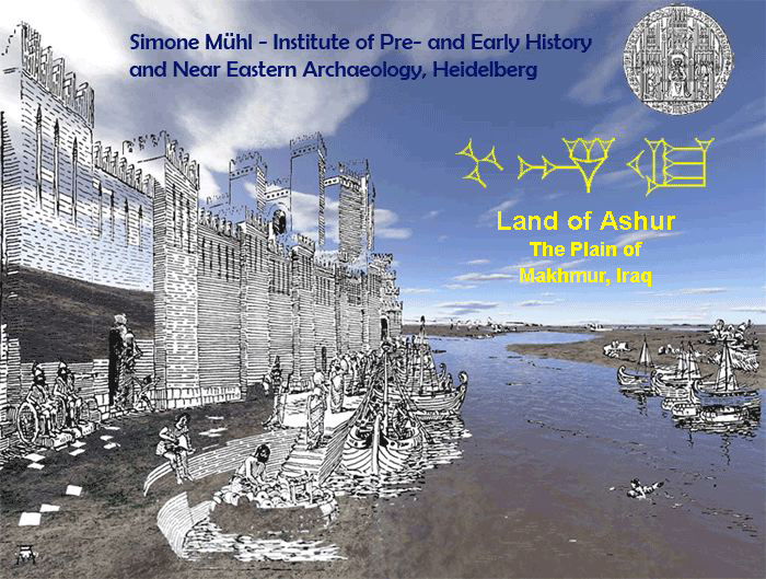
For more information see: The cultural landscape and settlement patterns at the Little Zab, Iraq
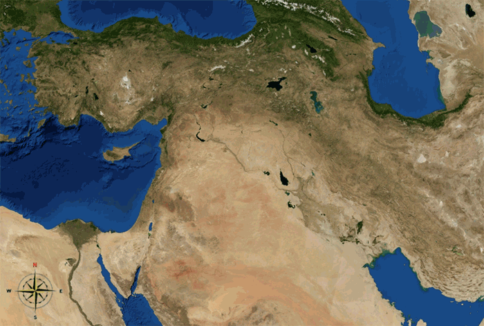
The terrain under consideration in this study is the plain of Makhmur, lying east of the river Tigris opposite Ashur, the religious centre of the Assyrian state and within the borders of modern Iraq. It is part of an area called in Assyrian antiquity mat Ashur – ‘land of Ashur’, named after the god Ashur, head of the Assyrian pantheon.
The north eastern part of the plain, which is bordered by the rivers Tigris and the Upper and the Lower Zab and by the Qara Chauq Mountains, lies within the very variable 200mm precipitation area where the minimum amount of rainwater essential for rain-fed agriculture falls in fertile years. The south western part is categorized as part of the Syro-Arabian steppe.
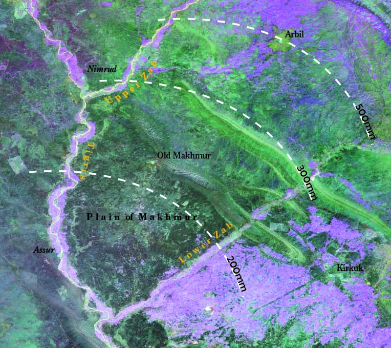
Pinkish areas indicate a high level of moisture in the ground due to artificial irrigation today, made possible by pumps running on petrol (Negative Landsat 7 ETM+ false colour).
Accounts of early investigations of the region can be found in the travelogues of 19th century travellers (mostly Europeans) who stuck to the routes beside the Tigris or along the piedmont, because of the rough, lonely landscape and dangerous nomadic and semi-nomadic tribes. Eduard Nolde's report of his travels through Kurdistan (Nolde 1895) is one of the earliest European travelogues of this area and is of particular interest from another point of view. He mentions a so-called 'secret route' which leads from Kirkuk to Mossul without going through Arbil, but instead goes over the northern part of the Makhmur Plain. Other travellers were early Near Eastern archaeologists such as Ernst Herzfeld and Friedrich Sarre who give us important information about sites along the Tigris, and also about the area of Arbil using the safe routes.
In antiquity the landscape was far from wild and hostile. The region flourished under a political system shaped by socio-economic factors in which cultural and religious aspects were also embedded.
Canals
The most prominent source of water in the region is the river Tigris with its accompanying river terraces: As a source this posed problems, because of the fast-flowing river which cut deep into the ground. In southern Mesopotamia the problem of large scale irrigation was solved by the deployment of large canal systems at the end of the 4th millennium, using the potential of the slow flowing Euphrates in flat terrain. The evidence from the plain of Makhmur seems to be later.
The majority of canals lie on river terraces, where it is easier to drain water from the Tigris and to channel it for gravity-fed irrigation parallel to the river. Behind the terraces the terrain is at a much higher level. The transition between plain and river terrace is formed by high conglomerates and deep cut wadis.
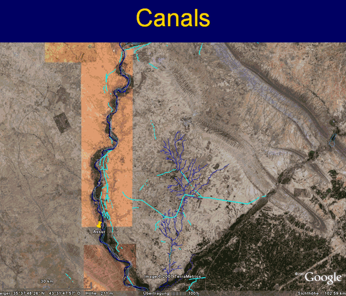
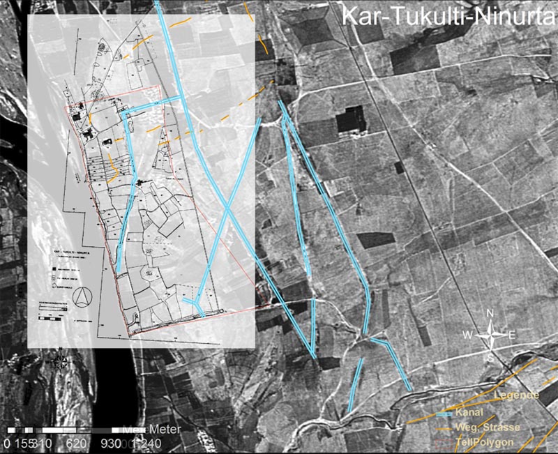
The canal system along the Tigris and within the Plain of Makhmur (turquoise/red lines). The features dating it vary from the Middle Assyrian to the Early Islamic period.
With the rise of the Assyrian empire in the middle of the 2nd millennium the demand for a stable supply of crops can be assumed to have been essential for the expanding political power in Northern Mesopotamia. According to the results of remote sensing, one of the earliest datable canal systems north-east of Ashur can be associated with the Middle-Assyrian city Kar-Tukulti-Ninurta. The city was a new foundation of the Assyrian ruler Tukulti-Ninurta I (1243-1207 BC). The canal that can be identified as the pattu meshari (canal of justice) is known to us from a royal inscription of Tukulti-Ninurta I.
From all the mapped canals one system seems to stand out: the so-called Makhmur canal which takes water both from the lower Zab and from Wadi Fadha which crosses the plain in several streams from north to south. It was first mentioned by Max Mallowan in his report on an expedition in the plain in the 1950s (Mallowan/El-Amin 1949, 1950). No research has been undertaken on it, although it figures on nearly every historical map of this region. Only Mallowan has suggested a date for it, intuitively placing it in the Assyrian period. This particular water project must have had enormous consequences for the economy of the region south of the lower Zab which strongly depends on water from the Zab being distributed to the fields by means of multiple channels. In the satellite images, the point where the water is taken from the river is traceable as a huge funnel which must have drained a lot of capacity from the river in order to transport water over a minimum distance of 27 km or a maximum of 56 km. The engineering was carried out with an impressive knowledge of surveying and environmental manipulation. Its course follows to some extent the elevation in the centre of the plain and takes advantage of the channel of Wadi Fadha. Additional water may have been brought into the system by a number of natural and regulated streams flowing through this Wadi. It is virtually impossible to say if various sections within the system date back to the same period. Evidence for dating could be provided by dated settlements cut off by these or by routes and hollow ways provided with bridges, or by 'hubs' resembling radial hollows.
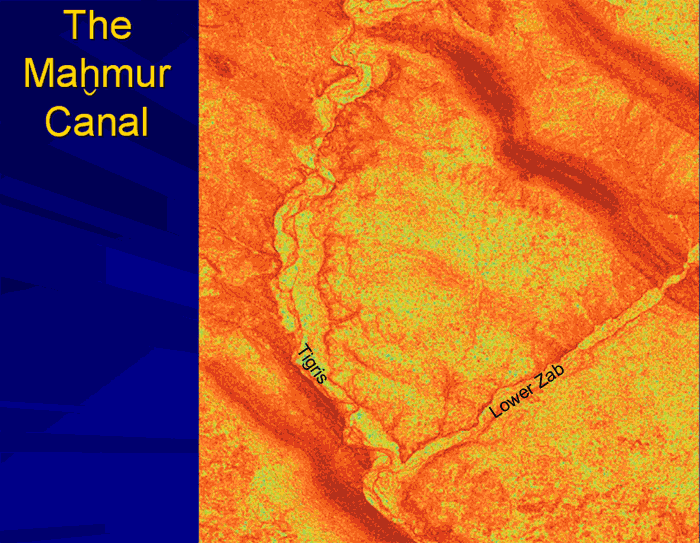
MakhmurCanal – water entrance of the Makhmur canal on ASTER and LANDSAT.
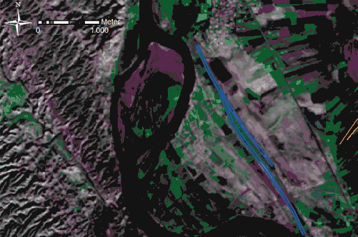
Apart from transporting water to fields, channels did not only supply river terraces with water for agriculture, but they also were used for fishing – to meet the requirements of individual elements of the population, the wider market and also the temple economy. Whether fish were used to provide nourishment for priests and/or gods or served as levies paid by farmers and fishermen to meet the demands of the temple economy in exchange for the use of the channel is uncertain. A combination of both is possible. A construction probably intended to shorten the waterway can be traced on a small peninsula north of the estuary of the Lower Zab where the Parthian and Islamic city Wadiyah al-Kurdiyah wa al-Sura would have been cut off from its overland connections. Another settlement of the Early Bronze Age and Middle Assyrian periods lies north west of the canal at the former riverbank. Smaller channels in close proximity to the settlement may also date from the middle Assyrian period, but only accurate surveying can verify this. For the moment it may be suggested that the degree of preservation and the physical structure indicate a date for the main feature in the Neo-Assyrian period.
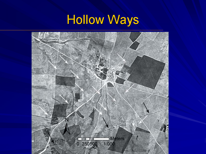
Hollow Ways and Settlements
Hollow ways, as described in the contribution of Tony Wilkinson to this workshop, are linear depressions in soft ground. Their formation is caused by the continuous use of tracks by men and animals, and also by vehicles such as sleds, carts or wagons (further details in Wilkinson 1993).
This definition is based on the assumption that people do not wander around aimlessly, but have specific starting points and specific destinations, for whatever reasons. Knowing in which direction to go requires information about the location of the destination and what lies in between. Changing political, economic, social or other conditions can lead to route changes, because of shifting destination points. The course of a route can also be determined by the intentions behind a journey.
The more frequently and more intensively a track is used, the more visibly it can be traced, because it is kept free of vegetation by trampling feet, hooves and rolling wheels. The ground gradually becomes compacted and sinks down where it has been trodden. At the same time, it affects the configuration of the effects of drainage, where rainwater accumulates and flows from the highest to the lowest point without trickling away. Fine grained materials are transported and erosion is expedited.
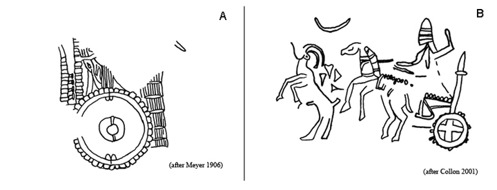
Important factors in accelerated erosion are carts, wagons and chariots which were in use in the Near East from the late 4th millennium. Wet tracks cause endless trouble for charioteers. The vehicles sink deep into mud, they become hard to manoeuvre and the wheels slide. To prevent the latter, so-called 'wheel shoes' of iron or of ropes wound around the felloe were commonly used. These wheel shoes were common in Europe from the Middle Ages to early modern times, and have been held responsible there for hollow ways cut deep into the ground. Similar problems can be assumed to have occurred in the ancient Near East, where depictions suggest that, in the late Early Dynastic to Ur III period (A) and lasting right down to the neo-Assyrian period (B), the chariot with profiled felloes should not be regarded as an 'off-road' model, but as an 'on-road' one.
Hydrological attributes cause enhanced plant growth (for more information see Ur 2003) which is in some cases traceable on ASTER imagery (Altaweel 2005).
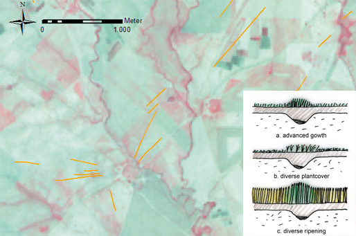
Features with similar hydrological attributes are wadi systems which can be divided into active and inactive wadis. Active ones are open or re-opened temporary water courses. An inactive wadi means that the drainage is filled with drifts, and loose soils are washed in by agricultural activities. These are detectible as linear hollows. In many cases the difference between both wadis and hollow ways is not easy to distinguish, because wadis can take over hollow ways and vice-versa. Sometimes only geometry and context can suggest an answer.
Filtered ASTER image. Dark green features reveal inactive Wadi systems.
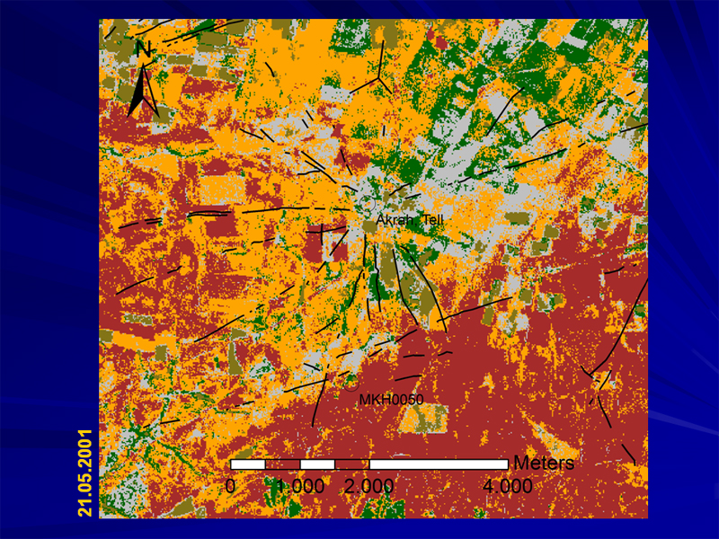
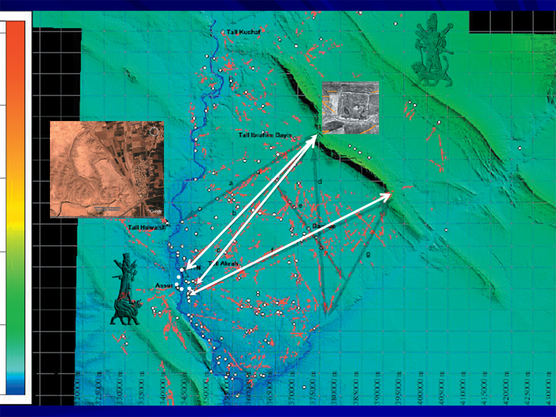
Mapping features suspected to be hollow ways within the plain of Makhmur on combined CORONA and ASTER provides a clear picture of the spatial communications of the land of Ashur. On CORONA images they can be traced as dark linear features. Spatial information should be combined with chronological information. This can be provided by examining archaeological sites which are assumed to have been incorporated into the region's communications network as represented by the remains of routes, but archaeological investigations are scarce within this plain.
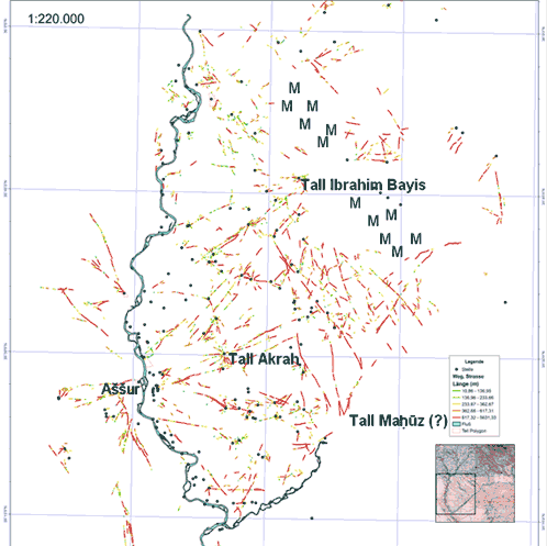
It is obvious that several routes lead in a west-east direction through the Qara Chauq Mountains towards Arbil which can be assumed to be a major key site of the middle 3rd millennium in northern Mesopotamia. It is also an important cult centre of Ishtar-from-Arbil, the goddess of war and love in her martial appearance, in Assyrian times.
The route through the Qara Chauq leading to the area of Kar-Tukulti-Ninurta on the river Tigris may date back to the old Assyrian period, and represents a route to a ford leading to Ashur which lies 3400m further downstream. The way back from Ashur to the East can be determined by a ford crossing near Sudairah (zoomed CORONA image within the animation below) which lay closer to the river in antiquity (Altaweel 2004). Here you can see many small tells, many of them dating to the Middle Assyrian Period, but none bigger than 50m in diameter. They may represent the remnants of small fishing settlements or farmsteads which supplied small markets in Ashur or profited in another way from ferry traffic.
Communication Dating.
Another dominant route starting east of Ashur passes by Tell Akrah, which can be supposed to be ancient Ekallatum, and leads to a southern pass through the Qara Chauq. From there it may turn southwards across the Lower Zab to Kirkuk.
A Puzzle of Historical Geography: The question of Tell Akrah and ancient Ekallatum
The city of Ekallatum is mentioned in the Assyrian King List as the base from where the Old Assyrian king Shamshi-Adad I. (1813-1781 B.C.) conquered Ashur.
'Shamshi-Adad, son of Ilu-kabkabi, went [to Karduni]ash [during] the time of Naram-Sin. In the eponym of Ibni-Adad, [Shamshi]-Adad [came up] from Karduniash. He captured Ekallati. For three years he resided in Ekallati. In the eponym of Atamar-Ishtar, Shamshi-Adad came up from Ekallati. He removed Erishu (II), son of Naram-Sin, from the throne and seized the throne (for himself). He ruled for 33 years.' (Greyson 1980-83, 105-6 § 12)
Shamshi-Adad I ruled from Shubat Enlil which is supposed to be modern Tell Leilan in the Khabur region, while he established one of his sons, Ishme Dagan, in Ekallatum to maintain control over the Tigris area and the routes to the south.
Several suggestions as to the identification of Ekallatum have been made. The most commonly accepted identification is Haikal, north of Ashur, which was first proposed by Walter Bachmann and later by David Oates (Oates 1968). A different identification was made by Emil Forrer who proposed Tell al-Dhahab, south of the mouth of the Lower Zab (Forrer 1920). Recently Reinhard Dittmann has suggested that Tell Akrah should be identified with Ekallatum (Dittmann 1995, also see here for detailed literature).
Concrete information which can lead to identification:
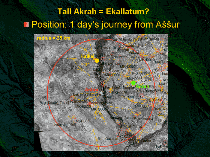
Haikal and Akrah are settlements that fulfil many crucial criteria. But when where those settlements inhabited?
No excavation has been undertaken at the site of Haikal. The posthumously published observations of Bachmann indicate a date in the middle- and neo-Assyrian periods. R. Dittmann, who visited the site, never found evidence for old-Assyrian settlement although many illegal excavations had been undertaken at the site by local people (Dittmann 1995).
At Tell Akrah, Mahmud El-Amin opened some soundings. At the foot of the tell he reported finding pieces of early Khabur ware of local fabric in Ashur-style. Another piece of evidence may be the tell itself. Tell Akrah belongs to the group of so-called 'Kranztells', named after their particular appearance. characterised by a polygonal wall enclosing an open area within the tell. In theory, the enclosed area is interpreted as a refuge for the pastoralists and farmers of surrounding areas in times of crisis. Although a cultural connection (Moortgat-Correns 1972) is nowadays dismissed, David Oates drew a chronological connection between the building phases of the walls at Tell ar-Rimah and Tell Akhmadi/Hamidi, both of them dating back to the Old-Assyrian Period (Oates 1985). Thus, the evidence seems to be clear that Tell Akrah is Ekallatum.

More about Routes
Turning away from puzzles in historical geography, attention is paid to the north-south/south-north connections within the plain:
In the Neo-Assyrian period another important centre lay north of Ashur: Tell Huwaish, a fortified city with remains of Assyrian and Post-Assyrian settlement. From here another route towards the Husain al Ghazi Pass in the Qara Chauq Mountains passes by the interesting site of Tell Ibrahim Bayis near Old Makhmur (Mallowan/El-Amin 1949, 1950). The site was inhabited from the Late Neolithic to the Early Bronze Age, and was resettled in the Neo-Assyrian Period when Shalmaneser III initiated the building of the rectangular defence wall. Its raison d'être is shown by arrowheads found in the in the proximity of the rectangular wall. As a hub of several routes, it can be assumed that its role was as a checkpoint for traffic, trade, and the security policy of the Assyrian state. The necessity for this arose from a persistent danger of looting tribes or other political threats coming from the Zagros Mountains. Along the route some other similar features can be observed, but their rectangular shape offers no evidence for a chronology nor do the sites allow us to classify them functionally without observations on the ground.
Following this short introduction to the area east of Ashur one question remains:
Why and when did these ingenious water systems and the whole infrastructure of this region collapse and become forgotten? There is no evidence for a connection between their downfall and the destruction of the Assyrian capitals by the Medes, the last being Nineveh in 612 B.C., indicated by the presence of many Parthian/Sasanian channels and sites. Nor did the onset of Islam result in a break. The region seems to have had a final boom during the time represented by huge projects like the large Nahr Qanausa canal (Altaweel 2004), and many more flourishing cities along the river as well as some within the plain.
The real collapse seems to have come with the Mongol conquest under the successors of Djingis Khan. They did not destroy the canals directly, but massive killing of the region's population led to neglect of their maintenance. The infrastructure of the region fragmented and it was subsequently inhabited by nomadic tribes and semi-pastoral people who from then on lived a more or less restricted life within the steppe.
This man-made landscape brought stability not only to a region, but also to a system which depended on a large enough population to maintain it. In the end, its fragility led to its own downfall.
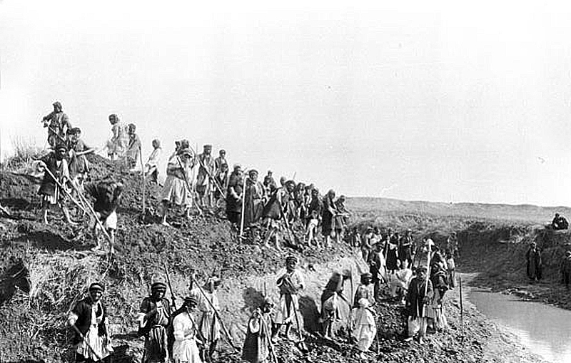
Work at the Nahr Rûd canal in southern Iraq (photo: G. Bell, March 1911
(Copyright Gertrude Bell Photographic Archive, Newcastle University).