 Occasional Papers (2009-)
 Site Visualisations
Jason Ur, Department of Anthropology, Harvard University
Introduction
The Near East presents particular challenges to the study of past landscapes. Remote sensing has been a part of archaeology for a century, and aerial photographic coverage is now the ideal and standard for field survey basemaps. Such coverge, however, is not globally available. In the modern Middle East, for example, easy access to aerial photography is often impossible to obtain. As a result, archaeologists have turned to satellite imagery. Unfortunately, the resolution of space-based imaging systems such as Landsat and SPOT is often too coarse for archaeological features. To some extent, this issue has been solved by the availability of commercial high-resolution imagery. However, such imagery is expensive and documents the modern developed landscape. Over the last decade, Near Eastern archaeologists employed a new satellite resource that resolves many of these issues: the declassified CORONA intelligence program.
CORONA and Landscape Archaeology
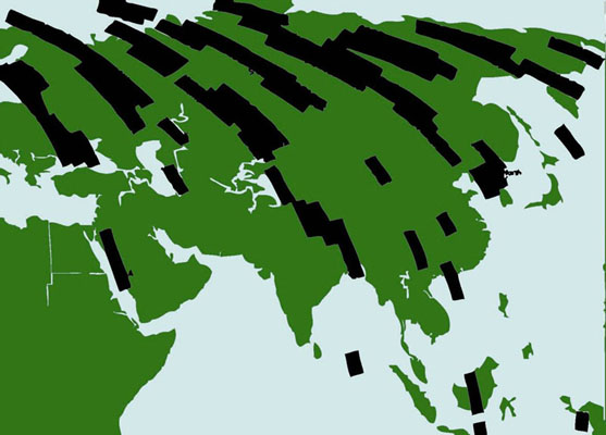
Typical coverage of a CORONA mission: Mission 1017, launched 25 February 1965. Note the intensity of coverage over areas of interest during the Cold War: North Korea, large sections of the Soviet Union, the Baltic states, and eastern Europe.
CORONA was a US Department of Defense intelligence program, in operation from 1959 to 1972 (Day, Logsdon, and Latell 1998). Its mission was to monitor Soviet missile strength, and in this it was a huge success. Features of interest identified by CORONA were further investigated by a companion 'spotter' satellite, named KH-7 (Richelson 2003).

The EarthExplorer search interface (http://EarthExplorer.usgs.gov).
Imagery from both programs has been declassified and can be previewed and ordered on the USGS EarthExplorer website. Individual scenes cost $30.
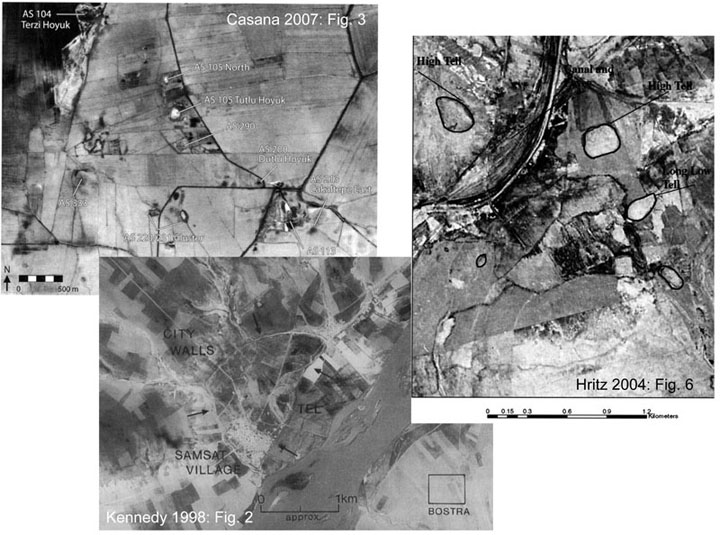
Archaeological research using CORONA imagery in the Near East: The Amuq Plain, SE Turkey (Casana 2007), the Upper Euphrates in Turkey (Kennedy 1998), and southern Iraq (Hritz 2004).
Archaeologists in the Middle East were quick to recognize the potential of this new dataset. The first archaeological application was by David Kennedy (1998), who examined sites in a now-inundated floodplain of the Turkish Euphrates. Systematic studies quickly followed: for example, settlement and land use in the Homs region (Philip et al. 2002, Philip in this ArchAtlas Workshop), irrigated landscapes in southern Iraq (Hritz 2004, Pournelle 2003) and Khuzistan (Alizadeh et al. 2004); settlement in the hinterlands of Byzantine Antioch (Casana 2007); and the urban landscape of Islamic Raqqa, Syria (Challis et al. 2002-2004), to name only a few (see review in Fowler 2004).
Resolutions: 30m
> 15m > 10m > 2m
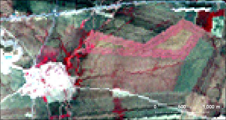
Resolution comparison between various satellite imagery systems for Tell Beydar, a walled Early Bronze Age (ca. 3000-2100 BC) center in northeastern Syria.
In addition to cost, CORONA has other advantages over more recent imaging systems. It is of high spatial resolution, in some cases better than 2m. When compared to Landsat, ASTER, and SPOT, often it is only CORONA that can resolve features of archaeological interest.
echo”
1967
> 2004
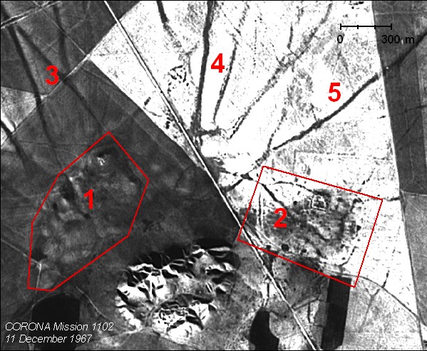
Progressive destruction of archaeological landscape features at Tell Brak, northeastern Syria between 1967 and 2004. Area 1: the subtle topography of the Late Bronze Age lower town has been plowed flat; Area 2: the linear canal features of the Late Antique-Early Islamic town have been removed via the plow; Areas 3-4: broad Early Bronze Age tracks have been effaced by mechanized agriculture and the expansion of the modern village; Area 5: it is only in this field that EBA trackways are still visible.
Age is a liability for intelligence purposes, but CORONA preserves an image of the landscape 40 years ago. QuickBird imagery might be of higher spatial resolution, but it postdates the expansion and mechanization of agriculture and other forms of development. CORONA often preserves features that are simply no longer extant.
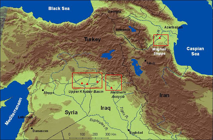
Map of the Near East, with case study regions indicated.
The result of these and other landscape studies has been a greater sense of the structure of ancient Near Eastern landscapes, and a powerful set of methodological tools for recovering them. The three case studies presented here show how a combination of CORONA analysis and ground observation can reveal such patterned landscapes and offer clues to the socioeconomic structures behind them. We will pay particular attention to the sorts of human agency behind these patterns.
Landscapes of Movement in Northern Mesopotamia
The first case study comes from the later third millennium BC in northern Mesopotamia, a time of urban expansion (Wilkinson 1994, Stein 2004). Several 100 hectare settlements were scattered across the dry farming plains in what is today southeastern Turkey, northeastern Syria and northern Iraq. At the pinnacle of the political hierarchy were substantial palace and temple households with considerable ability to organize labor. We know far less about the non-elite urbanites, but excavations in residential areas show the remains of densely packed domestic structures (Pfälzner 2001). The region has been agriculturally productive in modern times, so most scholars have assumed that the basis for political power was elite control over wheat and barley production.

1967
> 1969 > 1972 > Interpretation
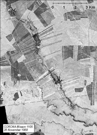
Hollow ways west of Hamoukar.
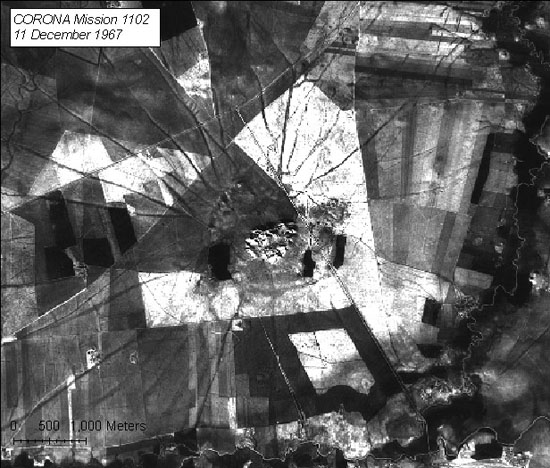
The landscape evidence for intensive agriculture and animal husbandry takes the form of broad and shallow linear depressions which are often referred to as 'hollow ways' or 'linear hollows' (Van Liere and Lauffray 1954-55, Wilkinson 1993, Tony Wilkinson in this ArchAtlas Workshop). Archaeological surveys have demonstrated a close association of these features with sites of this urban phase. They can be identified with difficulty on the ground, and often only in fragmentary form. CORONA satellite photographs are well suited to map these road systems (Ur 2003, in press). Their depressed morphology collects runoff and promotes vegetation growth, which appears as a dark line. With a series of georeferenced CORONA missions, it has been possible to map almost 4,300 kilometers of hollow ways across 11,000 square kilometers of northern Mesopotamia.
1967
> 1968 > 1969 > 1972 > 2001 > 2004
Hollow ways radiating out from Tell Brak in CORONA, Landsat, and ASTER scenes, 1967-2004. In the false color scenes, red represents vegetation.
At the regional level, two patterns can be distinguished. Inter-site routes run consistently between sites of the third millennium BC. The dominant pattern, however, is one of spoke-like radiations around sites, where the features extend out three to five kilometers and simply fade out. Two patterns emerge from these two types of movement. The intersite routes conducted people, animals and goods to and from settlements for trade and general social activities. The radial routes conducted people and animals to and from fields and pastures. In both cases, the tracks formed because the agricultural fields constrained movement, forcing the trampling feet of humans and animals onto the spaces between them.
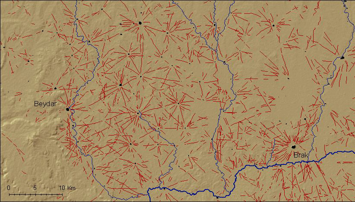
Hollow ways in the western-central Upper Khabur basin, as mapped from georeferenced CORONA photographs.
What does this distribution of radial networks tell us about past human agency? It is tempting to see this structured landscape as the deliberate product of centralized action, intended to generate economic surpluses. In fact, these tracks were not constructed by an administrative body but were formed by many thousands of human and animal feet in the course of their daily farming and pastoral activities. Top-down forces probably did played a role, most likely in the form of elite control of land, which constrained movement onto the tracks. However, in this case, the features themselves were emergent from the uncoordinated actions of individuals (Ur in press).
State-Sponsored Irrigation Systems in the Assyrian Heartland
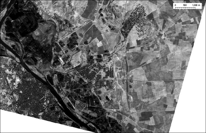
In the second case study, from the hinterland of what is today Mosul in northern Iraq, the creation of a structured landscape was the product of centralized forces. At the end of the 8th century BC, the king Sennacherib moved the capital of the Assyrian empire to the city of Nineveh on the Tigris. He then set about creating a settlement worthy of its status as imperial capital. He built palaces and temples, created a city wall enclosing 750 hectares, and excavated an elaborate set of canals to bring water from the mountains down onto the plain behind Nineveh (Oates 1968, Reade 1978, Bagg 2000). These components represent a unified attempt to redirect the surface drainage of the Assyrian plains toward his new capital.
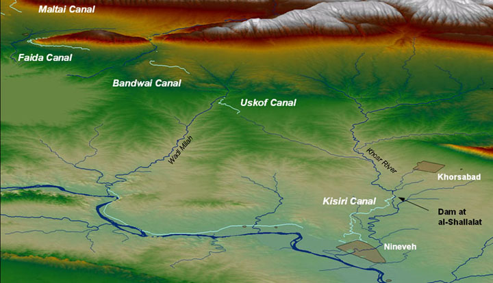
Canals in Sennacherib's 'Northern System.' Click on the canal's label to view a CORONA scene.
Our understanding of the canal network based on ground observations can be clarified and extended with the use of CORONA satellite imagery. Remote sensing sources allow the major elements of the system to be mapped accurately with reference to their topographic context. Ultimately, a CORONA-based reassessment mapped all previously located segments and added several new ones (Ur 2005). It revealed the integration of feeder canals over almost 200 kilometers, a scale which implies broad territorial control, organization of labor, and centralized planning.
EBA
> Iron Age
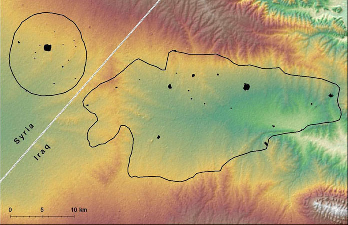
Evolution of settlement patterns in the Iraqi North Jazira and Hamoukar Survey Areas between the Early Bronze Age and the Iron Age. The highly nucleated EBA pattern shifts to an evenly dispersed on in the Iron Age.
This top-down ordering of the landscape was not limited to irrigation. Royal inscriptions and historical passages from the Bible record that conquered peoples were often deported to the Assyrian capital cities and their hinterlands (Oded 1979). Settlement patterns in the nearby provinces to the west show a landscape of regularly-spaced villages (see Wilkinson and Tucker 1995, Ur 2002). This regular pattern was the result of a state resettlement policy, to create an agricultural infrastructure of both water and human labor. Thus, the Assyrian landscape as revealed by CORONA appears to have been a highly imposed one, a product of top-down decisionmaking by a few elite agents in support of an imperial policy of economic and demographic expansion (Wilkinson et al. 2005). The role of emergent forces appears to be minimal, although crucial archaeological survey data remains to be collected.
Irrigation & Pastoral Landscapes in on the Mughan Steppe, Northwestern Iran
The final case study, from the Mughan Steppe of northwestern Iran, provides an example of how a single physical environment could host two very differently structured landscapes. CORONA assessment of the steppe reveals thousands of abandoned campsites of nomadic pastoralists. This decentralized landscape was superimposed over the remains of a carefully planned irrigation system of the late first millennium AD. Imagery analysis and field survey reveal the general outlines of this landscape's evolution (Alizadeh and Ur 2007).
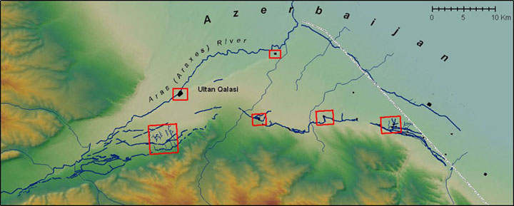
Sasanian fortified sites and canals on the Mughan Steppe. Click on the red boxes to view CORONA scenes.
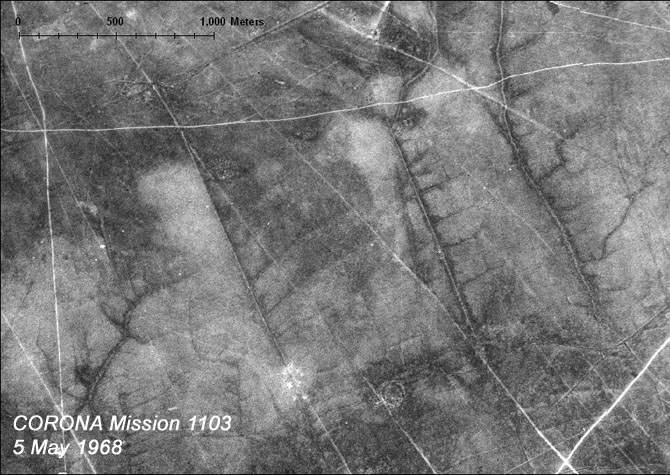
During the Sasanian era (AD 224-642), a powerful centralized state emerged from highland Iran to confront the eastern expansion of the Roman and Byzantine empires. As in the Assyrian case study, the state installed massive irrigation networks throughout its domain (Adams 1978, Alizadeh et al. 2004, Nokandeh et al. 2006), including the Mughan Steppe (Ur and Alizadeh in press). The traces of settlement extend far up onto the Aras (Araxes) River terraces and consist of evenly-spaced fortified structures and associated extramural occupation. The largest is the 28 hectare town of Ultan Qalasi. More common, however, are smaller sites such as Qishlaq Qaravol, the fortified component of which covers one hectare. These smaller settlements clung to the southern extent of the steppe, along the route of a feeder canal. In some places, the remains of elaborately structured canals and fields are visible on CORONA photographs.
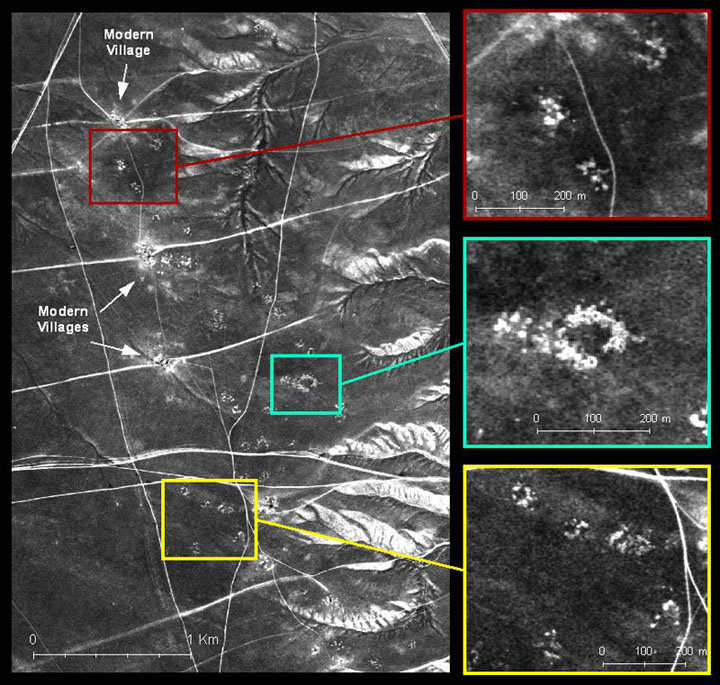
Shahsevan campsites on the Mughan Steppe (CORONA Mission 1110, 24 May 1970).
At some point prior to the tenth century AD, this centralized irrigation system collapsed. By the 18th century, it had been replaced by a decentralized landscape of nomadic pastoralists of the Shahsevan confederation (Tapper 1997). The Shahsevan were transhumant sheep and goat pastoralists who spent their winters on the Mughan Steppe. The Shahsevan wintered in 10-15 closely related households arranged in a circle around a central space (Tapper 1979). Their tents left few traces, but semi-subterranean shelters for their animals have left microtopographic traces visible on the ground and in CORONA imagery. The rings of backdirt from the excavation of these shelters are generally free of vegetation and appear as light circles. The depressed interiors collect moisture, and therefore appear as dark spots.

Continuum of Imposed-Emergent Landscapes.
In the case studies presented here, CORONA analysis has revealed a range of structured landscapes. At one end of the continuum, settlement and land use could be inscribed on the landscape by a few elite agents who closely administered them, as in the Assyrian and Sasanian irrigation systems. At the opposite end are emergent landscapes, whose structure results from the shared but not necessarily coordinated actions of many individuals or small groups, each acting according to a shared set of rules. This arrangement describes the organization of the tribes of the Shahsevan confederacy. The Early Bronze Age landscape of northeastern Syria resulted from both centralized and emergent structures. The farmers and pastoralists were motivated by the greater good of their individual households. At the same time, their actions were constrained by centralized systems of land tenure, which imposed limits on their movements. In general, however, most ancient landscapes were products of both emergent and hierarchical forces.
These patterns would have been difficult or impossible to recover based entirely on ground observations. The vertical perspective allows such patterns to be more easily perceived, once destructive cultural and natural processes can be factored out. These processes are particularly important in the Near East, where millennia of settlement and land transformation have created a fascinating but complex series of puzzles for the study of ancient landscapes.
CORONA and Damaged Landscapes
Prior: 1968
> During: 1987
> After: 2001 (at high level)
> After: 2004 (at low level)
The Wadi Aweidj dam north of Hassake, Syria, before construction, during construction and after completion. Mounded tell sites appear as islands in the reservoir.
As the global economy continues to expand, Near Eastern landscapes will be further threatened. Expanding populations require food and electricity, and one governmental response has been to erect dams. Here is the recent dam constructed across the Wadi Aweidj in Syria, just north of Hassake.
1966
> 2004
The expansion of Mosul, Iraq (SW of the Tigris) and the impact on the urban landscape of Nineveh (NE of the Tigris).
As populations grow, they have flocked disproportionately to urban places. Nearby archaeological sites and landscape features can be completely overrun without governmental protections.
1968
> 2001
The impact of the modern irrigation system on the ancient landscape of the Mughan Steppe, northwestern Syria.
As in the past, strong centralized governments in the Middle East today undertake large scale agricultural projects to sustain their growing urban centers. These projects, especially irrigation schemes, often involve earth moving and ground leveling which can wipe clean subtle landscape features. In this example, a modern irrigation system on the Mughan Steppe of northwestern Iran has completely erased the delicate brancing irrigation system of the Sasanian period. Here we are witnessing a cyclical process: it is quite likely that the Sasanian system had in its time erased features of the Iron and Bronze Ages.
In some cases, CORONA and other historical aerial and satellite imagery may be the only surviving record of the complex imposed and emergent landscapes of past societies.
Acknowledgements
All CORONA figures reproduced here are courtesy of the United States Geological Survey. Initial acquisition and processing of many of these scenes was made possible by the University of Chicago Oriental Institute's Center for Ancient Middle Eastern Landscapes (CAMEL, http://oi.uchicago.edu/research/camel/) and its former director Tony Wilkinson. I must thank the following individuals for giving me the opportunity to gain ground control in northeastern Syria: Tony Wilkinson and Marc Lebeau (Tell Beydar), McGuire Gibson (Hamoukar), and David and Joan Oates and Henry Wright (Tell Brak), as well as the Syrian Directorate General of Antiquities and Monuments in Damascus. For the Mughan Steppe Archaeological Project, I must thank Karim Alizadeh of the Iranian Center for Archaeological Research.