 Occasional Papers (2009-)
 Site Visualisations
Introduction
In our imagination of the 'Silk Routes', we envisage travellers, traders and intellectuals traversing vast continents for the purpose of exchanging rare and precious items (Whitfield 2004). The archaeological study of these routes has usually focused on transmitted artefacts and ideas, as opposed to the means and methods by which they were carried. The resultant void of knowledge concerning the infrastructure of the Silk Roads, and the nature of the settlements that shaped and were shaped by them, presents a challenge to archaeologists from both a methodological and theoretical perspective.
With the advent of digital technology, which enable wider landscape studies, it is possible to reach beyond the traditional model of major nodal networks, or straight lines between cities. The combined use of Geographical Information Systems (GIS), remote imagery, and field survey can help elucidate the location and function of way-stations and smaller settlements that facilitated the movement of goods and delineated established pathways. Seen in a temporal framework, it is also feasible that patterns can be observed for the changing of routes over time, reflecting climatic, cultural and imperial shifts, gleaning an insight into the workings of the Silk Route and its social construction.
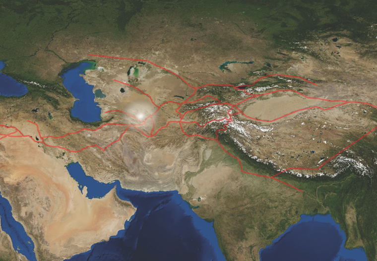
Central Asia and a representation of the major courses of the 'Silk Roads', indicating the pivotal western region
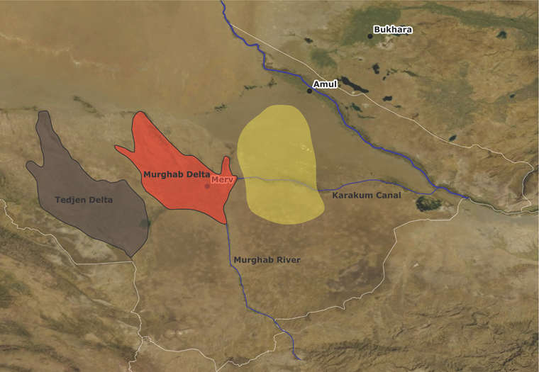
Central Asia can be described as a fulcrum of the 'Silk Routes'. The region forms a geographically central crossing point for many of the routes that emerge from Mongolia-China in the East and Iran in the West. As a hostile landscape with a dominant nomadic past, control of this area has fluctuated in a similar manner to the routes that crisscross its interior, most notably with the Arab expansion eastwards which influenced the region greatly. The Karakum desert occupies a belt of land between the Amu Darya (Oxus) river and the Caspian Sea and as an arid to semi-arid environment, presents a challenge to all those intent to cross it.
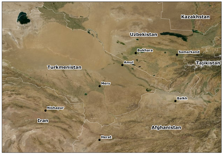
The region and cities discussed below on the borders of modern Turkmenistan, Iran, Afghanistan and Uzbekistan.
This essay focuses on a study area in the south-eastern Karakum that has been chosen as a pilot for examining the wider trade networks between Persia, Afghanistan and inner Central Asia. Given the expansion of the Silk Routes in the Abbasid and Seljuk periods (REF!) and their consolidation through Caravanserai and Khan, this time frame has been isolated as a key period for the crystallization of route structure and thus the major (but not exclusive) archaeological focus will be on material from this epoch.
Background
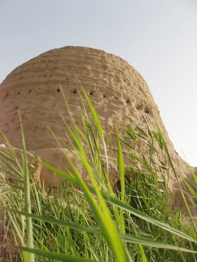
An icehouse at Merv – an example of the city's many elaborate architectural remains, which are testament to its importance as a trading town.
The pilot study outlined below is to be the first stage in a wider assessment of movement and routes through Iran, Afghanistan and Turkmenistan. Under the auspices of the Ancient Merv Project (UCL), one of the chief aims of the project is to situate the Historic city of Merv – Marv al Shāhijān (Wheatley 2001: 173) – in its wider context. Merv and its environs comprise a wide range of archaeological remains, from the palimpsest of cities that sprung up around the central site to the fortified residences or kösk that pepper the Merv oasis, to the remote caravanserai of the desert. The Murghab River has hosted cultures from the Neolithic up until the present day. Studying the formation of the city of Sultan Kala at Merv, the Ancient Merv Project has charted the fluorescence of the urban centre from the 8th-13th centuries, a time throughout which it never ceased to be an important trading and manufacturing centre, growing to, at its zenith, a total of around 550ha (Williams 2007: 45). Part of the ongoing investigation into the history of the city is to explore its role within a wider economic and social context, with its surrounding landscape as integral to this discussion.
A map of the two major river deltas in southwest Turkmenistan and the Karakum Canal, showing the pilot study survey area in yellow.
A number of initiatives have aimed to analyse Merv and the Murghab delta from a landscape perspective. The most significant comprise a whole series of investigations by Soviet scholars since 1947, into the archaeology of the upper Murghab and its environs (Gubaev, Koshelenko, and Tosi 1998). The wide-ranging remit of the Archaeological Map has enabled the analysis of the changing delta from formative societies to the medieval Islamic settlements, looking in particular at patterns in relation to the shifting Murghab river.
The current initiative, the major focus of this paper, was launched by the Ancient Merv Project in 2008-2009 is the mapping of the routes across the Karakum desert. The project will combine high resolution satellite imagery, historic maps and walkover survey in order to identify the remains of way-stations and caravanserai of the routes traversing the Karakum from Merv to the Amu Darya (Oxus) River. Many of the Medieval roads and routes are well documented by contemporary Arabic and Persian speaking historians, whose notable geographies (for example Ibn Khordadbeh's Kitā-b al-Masālik w'al-Mamālik) form a good base for comparison and give a key insight into the social framework of these patterns of movement. Furthermore, it is pertinent to question the extent to which the official routes and metalled roads provided the only means of transport, or alternatively how they coexisted alongside 'unofficial' or less organised trade networks.
A number of key questions have become the chief foci of the Karakum Routes Survey 2009, but above all the project aims to quantify the routes and roads that are archaeologically observable in this part of the desert. Gaining an idea of the scale of movement and the primary channels, it will be possible to further refine the methodology for their analysis, and look to building a more detailed chronology of use. If, as anticipated, the remains of caravanserai are the chief site form being identified, a major query would be as to the basis of their construction, and whether this can be read as a sign of centralized Imperial control. If this is the case, what can be inferred about the level of influence of the Empire, the military presence in the region and the taxation system? Alternatively, does it appear as though way stations formed independent units, tolling personal fees for providing rest and respite? A key aspect in the former idea of state maintained routes is the idea of post roads. The way stations of the postal system crossing the Karakum Desert are described by several Arab geographers (as reviewed by Zhukowski 1894) and the characteristics and spacing of caravanserai can be compared to their accounts to elucidate whether or not sites formed part of this Empire wide system. Finally on a more general level, it is hoped that pinpointing sites across the Karakum desert will illuminate some of the salient features of living and maintaining a presence in this extreme and hostile environment, giving a glimpse into fundamental practices such as water management, pastoralism and associated settlement patterns.
Landscape background
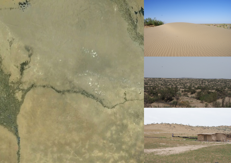
The varied desert landscapes of the southern Karakum.
The Aralo-Caspian basin is thought to have once been occupied by a large expanse of sea, which gave way to high undulating dunes of alluvium and aeolian sands (Pumpelly 1908: 292-293). This has been proven in more recent years through the vast oil prospection and subsequent coring in the region (Ulmishek 2004). The rivers which once fed into the basin have been recognised as dynamic and thus even in the historic periods potentially followed quite different courses. In spite of this it is clear that desert deltas were the primary foci of occupation in Turkmenistan from the prehistoric periods onwards.
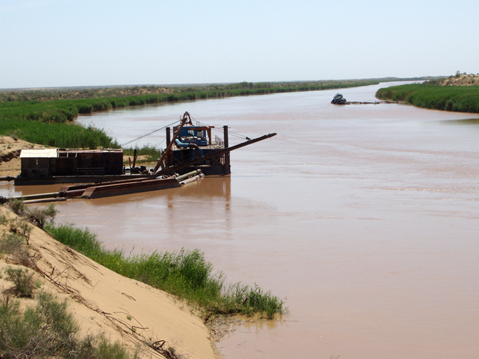
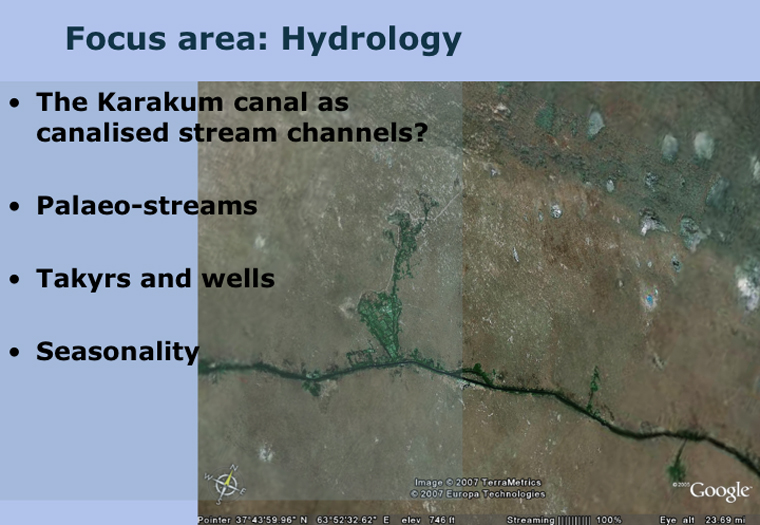
Between the oases there would have inevitably have been large stretches of desert and the route from Merv to the great river would not have been well watered. In hydrological terms it is thought that the only two water sources at this time would have been deep wells and takyrs (seasonal lakes). In modern times the particular stretch of landscape under examination is dominated by the Karakum Canal. Currently the largest irrigation channel on the planet, this Soviet feat of engineering has had major environmental impacts, not least as in recent years it regularly leaches vast amounts of water into the desert (Precoda 1991). The construction of the Canal not only alters the overall impression of the Karakum landscape, but is a serious threat to the survival of archaeological remains, through the processes of intensive agriculture and increased soil salination.
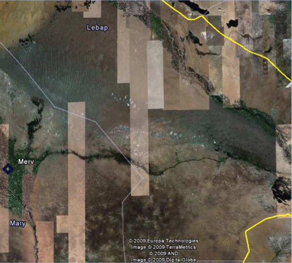
The view as seen on Google Earth shows something of the scale of change since the construction of the Amu Darya, as a broad streak of dark green bisecting the mottled linear dune formations. As well as the collectivised farms enabled by irrigation, the industrialisation of towns in Turkmenistan largely during the Soviet era promoted the construction of major roads and railways which further hinders the remote sensing of archaeological features.
A snapshot of the Karakum Canal from 2007 showing something of its impact on the surrounding desert.
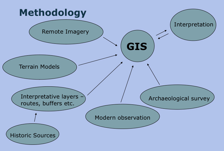
The means of determining routes and identifying pathways across the study area begins with the assimilation of all the disparate source data into a single analytical framework. Given the variety of information which it is necessary to combine the most logical forum for storing the data is as a multi-scalar GIS. Such an approach is ostensibly landscape orientated but allows enquiry on a number of levels, moving from isolated caravanserai, sometimes with visible layout detail, to broader assessments of movement corridors. In advance of the first pilot ground survey, it is anticipated that available satellite imagery, historical maps and geographies and topographical information will all be combined to identify a target area for investigation. Once this zone has been delineated it will be possible to test remote signatures of sites such as caravanserai by 'ground-truthing' or survey of the areas. Further to this areas of topographic significance or hydrological anomalies will be isolated for walkover survey, in order to locate ceramic scatters of more ephemeral or more greatly degraded sites. The following slides give some impression of the range of sources which will initially inform the survey.
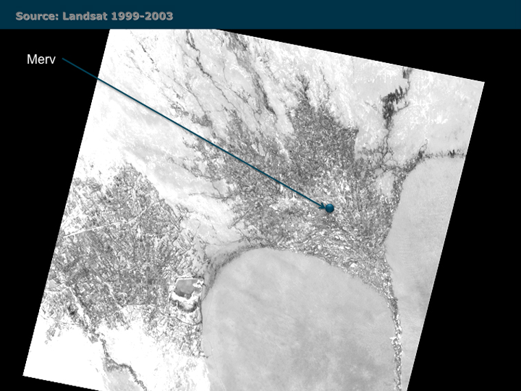
A Landsat 7 Image of the Murghab delta region.
Landsat images as obtained by NASA provide a good detailed overview and starting basepoint for remote sensing. Landsat 7 acquired between 1999 and 2003, the standard resolution for the latest edition in the visible spectrum being 30m. At this range, it is particularly useful for examining broad geographic and geological features across the study area. Palaeo-channels, takyrs and natural basins appear as visual anomalies which can then be selected for further investigation, either using desk-based analyses, or on the ground. When combined with topographic terrain data, Landsat imagery also forms a good platform to view archaeological data, highlighting the setting of sites and enabling us to draw conclusions about the pattern of their location in the wider landscape. It is however too coarse a resolution remote imagery for site detection on the scale of the archaeological remains expected in the survey.
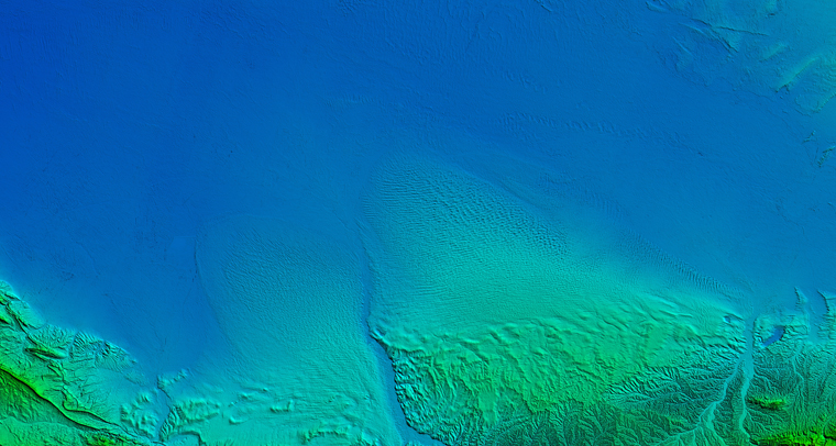
An ASTER DEM of the southern Karakum region.
The widely available USGS SRTM 3 Arc Second DEM provides global coverage to add three dimensionality to the analysis of the broader desert landscape. Whereas the predominant impression from satellite and aerial imagery is one of fairly limited topographic variation, the SRTM data highlights that this is in fact an erroneous assumption, and there are a number of important gradients in the desert land form, as well as numerous natural basins.

The comparison between Google Earth imagery (left) and Corona decommissioned satellite imagery (right).
The combined use of Corona and Google Earth imagery allows medium-resolution identification of both landscape and archaeological features. Human alteration of the landscape on a site specific level tends to be fairly striking in the local geology, normally appearing as a significantly lighter area. As Google Earth releases increasingly higher resolution imagery for this region, it is possible to identify the forms of the features themselves, noting wall lines and basic construction elements of the larger architectural ruins. At present this extremely high resolution area only covers a small proportion of the Karakum desert, which has therefore formed the focus of this preliminary study, as it allows for a full range of analyses. It must be noted, however, regardless of the clarity with which it is possible to detect human interventions, the dating of these events remains elusive unless it is possible to match the data to existing studies, or conduct 'ground-truthing' for ceramic samples and other clues as to the site's age.
Background Image: Russian map at 1:100,000 scale from the 1970s showing details of the tracks, vegetation and occasional settlements in the Karakum desert.
A number of interpretative sources have charted and described the Karakum Desert with varying degrees of detail. The surprising picture that emerges from the existing documentation, almost without exception, is that this Turkestan desert has never been cultural and social void, but in fact has perpetually hosted a number of settlements route-ways and watering holes.
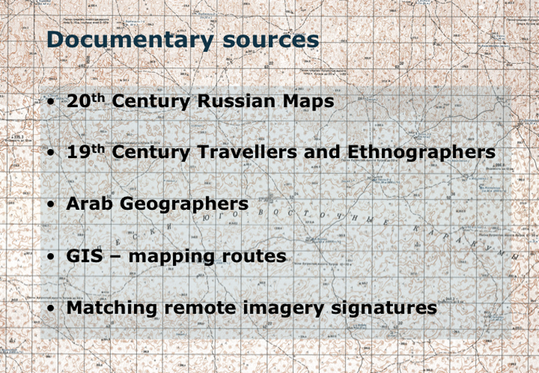
Documentary Sources: Soviet-era Cartography
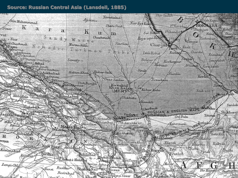
Henry Lansdell’s Map of Central Asia (1885).
The most detailed maps from the modern era come from the latter part of Soviet occupation, whereupon charts were constructed for the whole of Turkmenistan, noting contour information, populated, water resources and even visible ruins. Whilst it is clear that there exists an extremely comprehensive edition of these surveys at a scale of 1:10,000, the most widely available maps with the greatest overall coverage are the 1:100,000 series, which nonetheless still contain an astonishing level of detail. The Russian maps indicate the patterns of modern desert shepherding outposts and watering holes which is informative to locate regions which are still inhabitable and may have been occupied previously. In comparison to earlier maps and written sources, it is pertinent amongst other factos to look at enduring axes of major trade arteries, which appear to follow a fixed course between Merv and Chardzhou on the Amu Darya (ancient Amul, post-Soviet Turkmenabat).
Documentary Sources: 19th Century Cartography and Journals
Owing to the pivotal importance of Central Asia in the eyes of the great Imperial powers of the 19th Century, area known as Turkestan was subject to a number of studies from Russian, French and British scholars and travellers, who aimed to document as much detail of the landscape and its occupants as possible. Although a number travelled with what one might term 'genuine' travel-experience impetus, the majority had connections with the armed forces of one nation or another, thus in many cases were accustomed to setting down copious detailed notes on the local environment and other interesting features. Of the most detailed maps, those such as Landell's 1885 chart stand out as being extremely detailed, which document not only small settlements throughout the desert, but a number of paths across it. Cross comparison with Russian maps and modern Google Earth place names elucidates the precise location of a number of these small outposts, and identifies those which have subsequently ceased to exist. Cultural-anthropological observations such as the 'harvesting' of water from takyrs, and traditional transportation methods can also shed some light on the pre-modern characteristics of life in the barren wilderness.
Documentary Sources: Early Arab Geographers
From the times of the early conquests onwards, the Caliphates must have been well aware of trade routes in this Eastern extent of the Empire. Indeed there are brief accounts of pre-Islamic Empires passing through the region, the most notable being the campaigns of Alexander the Great. However, the first detailed itineraries of travel across this portion of the Karakum are provided by Arab geographers, and the earliest of these in 9th century, when Ibn Khordadbeh described the route in his Kitā-b al-Masālik w'al-Mamālik (Ibn Khordadbeh 1967), and more importantly the stops along it. Accounts such as this are invaluable in terms of their descriptions of the formal roads which were travelled by merchants, dignitaries of the Arab Empires, and post couriers. It is only through analysing this primary documentation alongside the archaeological data that we can approach the personal and political aspects of trade and travel in the medieval period, as well as their physical and material nature. It is possible to combine this information with spatial data in a number of ways. Aside from plotting the likely location of documented loci in the GIS database, it is also possible to use 'fuzzy' buffers that reflect travel times to match named waypoints with archaeological signatures, and connect configurations of known sites to examine the accuracy of estimated journey time.
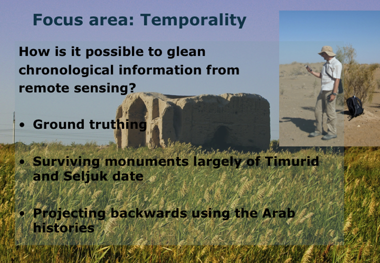
One of the major criticisms of remote sensing is the inability to observe chronology for the features identified. This argument has particular resonance in a landscape, which like most is still evolving and being used in a modern context. Furthermore, as the structures and sites identified are in most cases some distance from each other, it is not possible to infer relative chronology based on alignment and visible inter-truncation of deposits. The crudest method of assessing the date of these remains is to estimate that those ruins which are clearly the remains of caravanserais are most likely to be of Seljuk or Timurid date, as these are the periods during which the routes in this region are reported to have received the most significant logistical investment. However, this is a gross assumption which does not stand up to rigorous investigation.
The only means by which it is possible to gain a more accurate idea of absolute dates is to ground-truth the sites and collect representative ceramic samples from each. As there is a good typology for ceramics of this region which is regularly refined, it is possible to give broad date ranges for the latest phases of occupation at any given site. However, assuming a reasonable level of structural reuse, this method is still constrained by the fact that the majority of sites will be observed as Seljuk or later, biasing the dataset against earlier foundations. A caveat of this initial project should therefore be that only a limited temporal picture will result in the first instance, with a need for sample excavations at identified sites to clarify how these routes were maintained for any given duration.
One of the most elusive questions concerning the nature of travel across the Karakum is that of hydrology. In such an inhospitable dry basin, how was it possible to maintain a human presence on a permanent basis? The 'harvesting' of water from takyrs has been noted in anthropological sources from the nineteenth century, although this is necessarily a seasonal activity given the periodic nature of these lakes. Sardobas (covered reservoirs) are common in ecologically similar parts of Iran and Uzbekistan but would likely be very difficult to detect from remote sensing, given their small size. Nevertheless, where charted on nineteenth century maps it will be possible to try to pinpoint sardobas in the field.
Significantly more detail can be elucidated through analysing the pattern of modern and ancient wells using twentieth century Soviet maps. Charts produced during the 1970s document the position of a great number of wells across the desert, which are often the locations of current shepherding outposts. On closer inspection, these wells take advantage of natural basins in the landscape where the water table is closer to the surface. Furthermore, each of the wells on the Soviet maps has its depth by way of annotation. This has allowed the reconstruction of the approximate water table depth below the surface, at the time the wells were constructed. Interpolating this information into a continuous 'surface', it is clear that those areas in the southern region of the study area have to dig down up to 100 metres to retrieve water, as opposed to the far north where well presence is less prominent (presumably owing to a greater number and reliability of takyr sources) and the average depth is merely 5-15 metres. It is not possible to project this height data back to historical periods as the water table has likely fluctuated greatly. Nevertheless, the relative depth of the water table in this region can be assumed as constant, indicating that water was much more difficult to extract the further southwards the settlement, and well sources for some areas would be impossible without the aid of machinery. The overall inference is that the main northerly road, as described by contemporary travellers may well owe its existence to the presence of more reliable water sources.
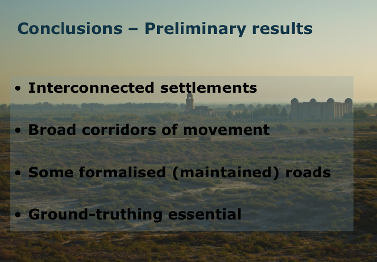
The settlements identified through the processes of archaeological survey outlined above cannot be examined in isolation. Movement and connectivity are key aspects of analysing the form of sites, their distribution and their chronological longevity. Discovering how the loci identified through remote survey are connected will form the thrust of ongoing research into the Karakum routes project, but a number of initial conclusions can begin to be drawn, even at this early stage
Firstly it is clear that we have to consider carefully the semantics of the labels with which movement in this context is labelled. There were most certainly roads in crossing the Karakum in antiquity, but the nomenclature relates specifically to those avenues of movement that were crystallised, either through the provision of wayside amenities or road maintenance such as paving, compacting or scrub clearance. This is to say that 'roads' are formalised entities, recognised by the traveller as distinct courses to travel between given nodes. Other routes through the landscape can be termed 'paths', or the informal course of movement along a trajectory used once, or many times, but not formalised through extensive embellishment, and not necessarily connecting two specific known loci. Paths to gather resources and paths between grazing areas illustrate two likely occurrences. Owing to the existence of a number of natural basins, smaller modern settlements and archaeological signatures across the wider landscape, it appears as though both 'roads' and 'paths' coexisted in the medieval period. The former will be more easily recognised, having features such as caravanserais, protective forts and tax stations along its course. Paths on the other hand may only be inferred through the background scatter of artefacts indicating low level movement across more isolated parts of the landscape.
The question of trade still remains to be answered, given the location of the study area on the famed 'Silk Road'. It is merely possible to hypothesise at this early stage, yet it is reasonable to expect two systems of movement trading across this landscape. Roads carrying long distance goods quickly, through a state maintained trading system to major destinations and redistribution centres, whilst contrastingly the presence of paths suggests an alternative: slower percolation of cargo through an informal and possibly unregulated network.