 Occasional Papers (2009-)
 Site Visualisations
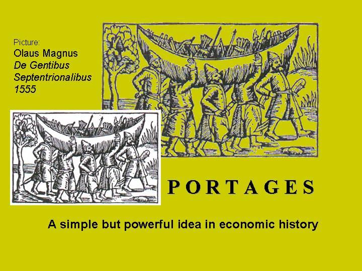
This sequence of maps illustrates a paper presented at the conference "On the Significance of Portages" in Lyngdal, Vest-Agder, Norway 29th Sept-3rd October, 2004. A full written version of the paper will be found in the conference publication (edited by the Conference organiser, Christer Westerdahl, to appear 2006). The maps and satellite images are provided here with an abbreviated commentary.

An isthmus is a narrow neck of land separating two bodies of water, interrupting a passage by boat. Where small quantities of goods are involved in trade, it may be possible to carry them – and even the boat – across the obstacle. The importance of portage across an isthmus for understanding early trading routes was first recognised by Victor Bérard in 1902, who termed it the "loi des isthmes", and the key to understanding ancient seafaring. As the volume of traffic grew, such "short-cuts" gave way to long-haul routes around capes and promontories, with continuous bulk transport by sea.
* "Isthmuses" is an awkward plural in English, hard to pronounce, but better than the alternatives.
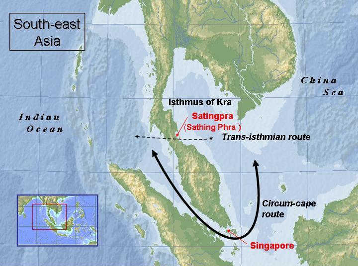
1) A classic example is the Isthmus of Kra in present-day Thailand, on the narrow neck of the Malay peninsula, which separates the Indian Ocean from the China Sea. It became important with the growth of Indian Ocean traffic from the third century AD onwards, and the appearance of trading states under Indian influence. The development of maritime contacts between India and China created the need for portage across the isthmus to convey goods from one side to the other, and several towns grew to prominence with this traffic. From the fourth century onwards this was supplemented by the longer passage through the Malacca Straits, with the rise of Srivijaya in Sumatra. After AD 1400 the growing volume of long-distance sea-traffic was decisively displaced to the route around the cape, leading to the rise first of Malacca (founded by the Chinese), and then, when it silted up, to the foundation of Singapore in 1819 (by the British).
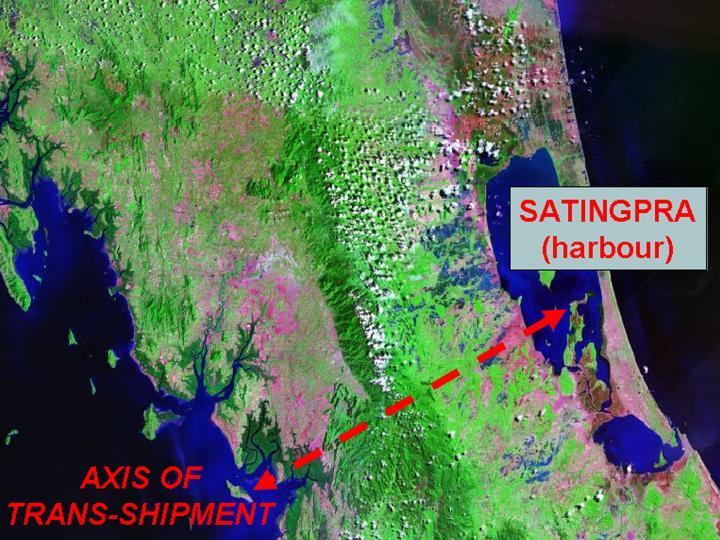
2) The site of Satingpra was a major port in the period from AD 1000-1400, supported by irrigation and with artificial channels to allow shipping to enter the lagoon. This period was called "the isthmian age" of south-east Asian trade by Paul Wheatley in his classic account, The Golden Khersonese (Kuala Lumpur, 1961). Its importance diminished when the long route via the Malacca straits route took over; but the possibility of a canal (at a different point across the isthmus) was first mooted in 1677, and is still discussed today.
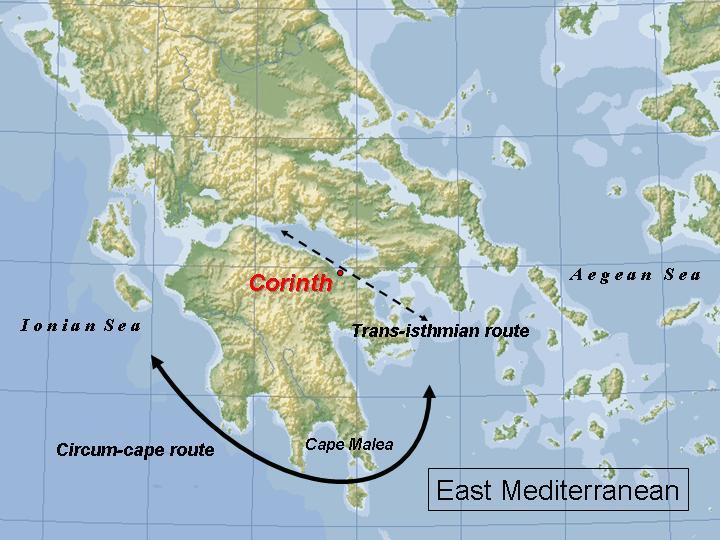
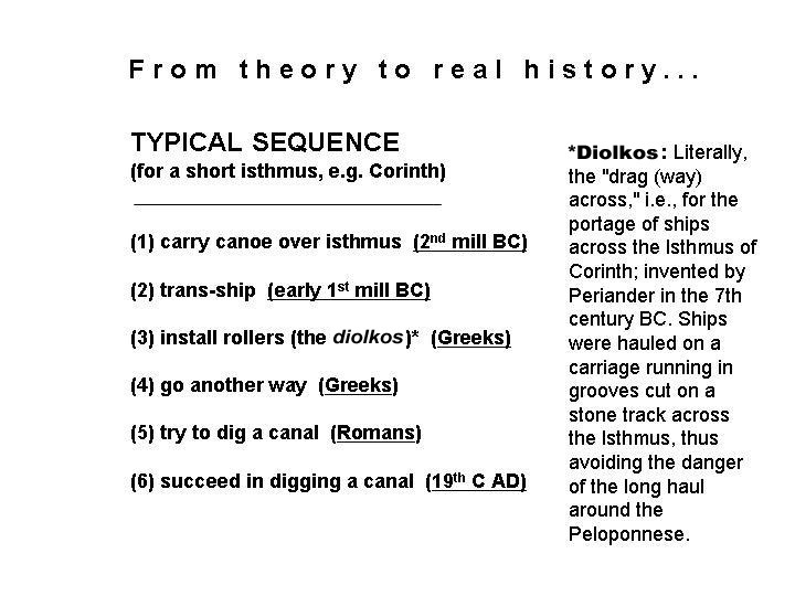
3) A precisely similar situation to that of Satingpra explains the importance of Corinth in ancient times. Passage between the Aegean and Ionian Seas (and thus between the east and central Mediterranean) used the sheltered route along the Corinthian Gulf rather than the exposed route round Cape Malea, necessitating transport across the narrow isthmus which separates the Corinthian Gulf from the Saronic Gulf (on which Athens is situated).
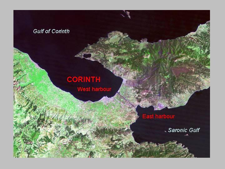
4) In the early part of the first millennium BC, small vessels would have been hauled across the isthmus; later, a special haulway was constructed. When vessels became too large, the goods would have been transferred between different vessels, operating from the two harbours, one on either side of the isthmus. For large quantities of bulk goods this was impractical, and eventually Corinth lost its importance to Athens. Attempts to dig a canal across the isthmus in antiquity were unsuccessful, and this was only achieved in the nineteenth century.
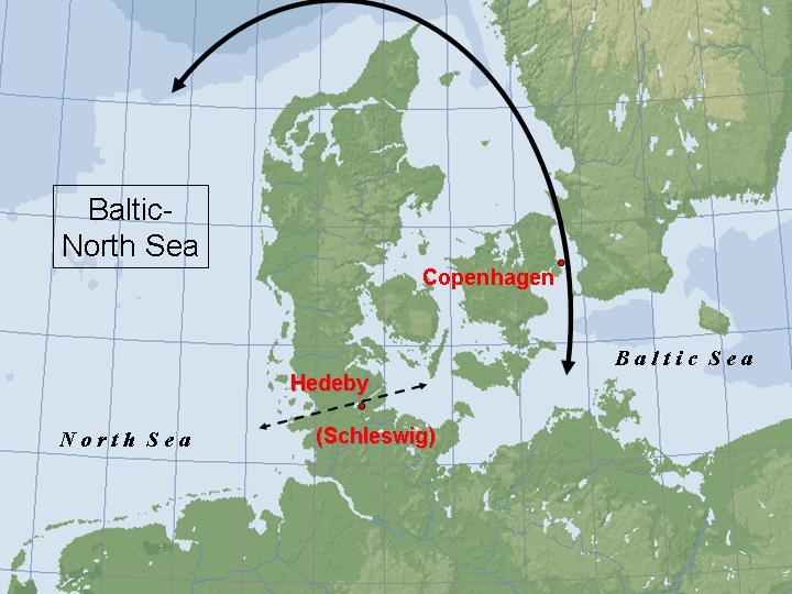
5) A third classic example is the narrow neck of the Jutland peninsula, separating the Baltic from the North Sea, where a short overland route avoided the long maritime trip round the northern cape (Skagen, The Scaw). This explains the importance in Viking times of the site of Hedeby (Haithabu), predecessor of medieval and modern Schleswig, on the other side of the long Schlei estuary. With a growing volume of Baltic traffic, the development of long-haul routes around the cape shifted the advantage to sites on passages in the island-studded neck of the west Baltic, chiefly Copenhagen. Finally, at the end of the nineteenth century, a canal was constructed, linking Kiel to the mouth of the Elbe.
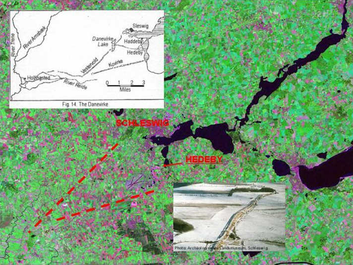
6) The route from Hedeby to Hollingsted on the opposite coast was protected by lines of earthworks known as the Dannevirke (Danæwirchi) or Danewerk, constructed by the Vikings between the eighth and twelfth centuries.

A long-term trend from purely overland (or riverine) routes to maritime relay-routes and then long-haul routes can be observed on many occasions in global history. This relates to the economics of transport, and the lower costs of carrying large quantities of goods by water, with no break of bulk.
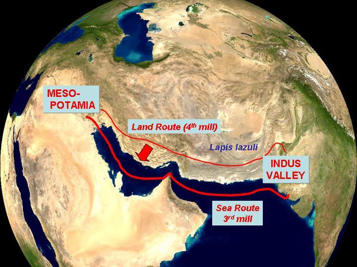
7) A classic example of this is provided by the long-distance routes which supplied exotic, high-value commodities to the earliest urban communities in Mesopotamia. During the fourth millennium (Uruk period) and early centuries of the third (proto-Elamite period), highland products such as the rare and distinctive blue mineral lapis lazuli were carried between a chain of settlements across the Iranian plateau. In the later third millennium, with the development of the Harappan civilisation in the Indus valley, these and other goods were carried along the whole length of the Gulf by sea.
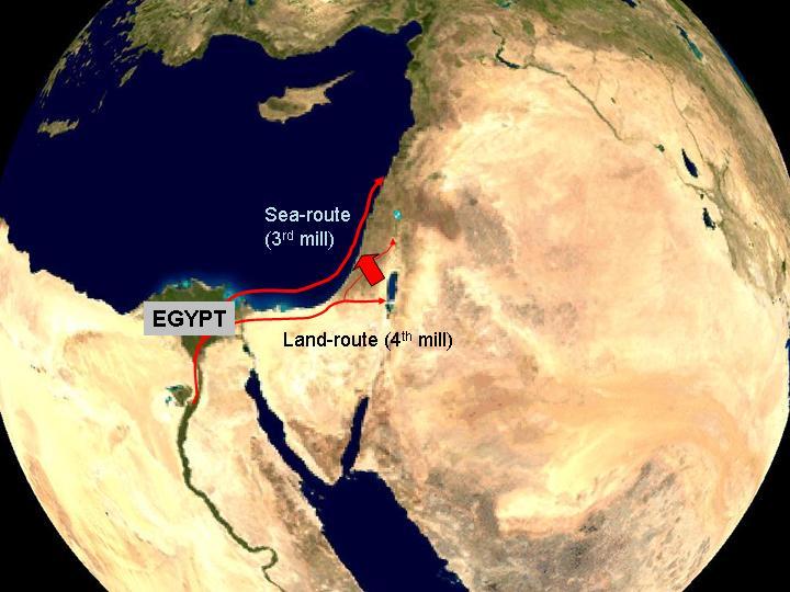
8) A comparable shift took place, at much the same time, in the southern Levant, in relation to Egypt. During the later centuries of the fourth millennium, Egyptian colonies were established in the lower Jordan valley, supplying high-value exotic products both organic and inorganic, and stimulated indigenous urbanisation. During the course of the third millennium the development of a maritime route up the Mediterranean coast to the Lebanon was able to supply many of these goods more efficiently, and shifted the focus of prosperity.
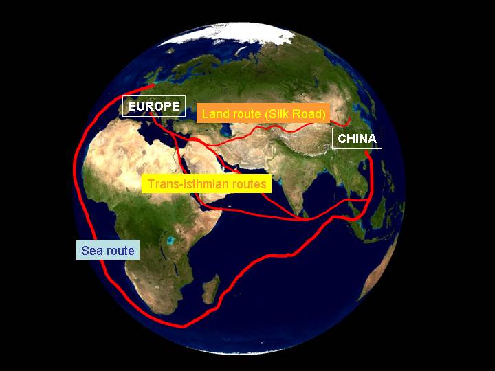
9) A similar pattern may be observed, on a much larger scale, for the whole of Eurasia, between the western and eastern ends of the Old World. The Silk Road was a caravan relay route across the centre of the landmass, carrying small quantities of luxury goods, which linked pre-existing routes carrying lapis lazuli and jade, from the later first millennium BC until the later middle ages. Partly in parallel to it, the routes collectively known as the Spice route linked the Mediterranean with the Indian Ocean via the Red Sea and the Gulf (the Egyptian and Mesopotamian Isthmuses), thus linking maritime spheres by way of short land-routes, and making use of seasonal differences in monsoon winds within the Indian Ocean. These routes were gradually superceded (until the cutting of the Suez canal) by long-haul routes around the Cape of Good Hope, using the Atlantic trade winds, still used for large tankers and container traffic. (Note, incidentally, how the different routes "plugged in" at different points in Europe and China, and how the focus of economic activity shifted, from south to north in Europe, north to south in China.)
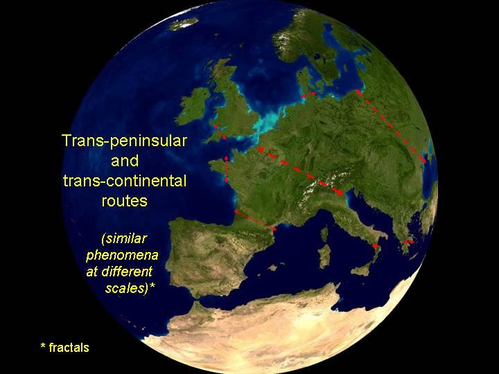
10) These examples of trans-isthmian routes, from the few kilometres separating adjacent seas to transcontinental routes between oceans, show that the concept can be applied over a whole range of scales, and that similar models can be applied to each. Routes across the European peninsula, beginning with the "Amber routes", also fit into this description (as Fernand Braudel pointed out). This nesting of route-segments within larger routes, each evolving within its own logic of connections, forms a complex pattern of fractal development. Trans-continental routes (often following rivers) became axes of urbanisation and economic development, and feeder routes developed in relation to them. The development of new routes often bypassed formerly important areas and resulted in their relative decline.

The reasons underlying these regularities in the development of transport routes relate to the nature and volume of goods in transit, and to the scale of economic organisation and capital investment involved in moving them.
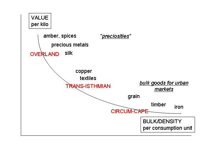
11) Where the commodities of trade are small in bulk but high in value, they may easily be carried, and over surprisingly long distances: even before the beginnings of farming, obsidian was traded for distances of 1000 km or more, through many different transactions. The classic long-distance routes of early times were concerned with such "preciosities", widely in demand between different cultures, for their exotic character and visual appeal – lapis lazuli, jade, amber, feathers, precious metals. With the development of urban economies, larger volumes of goods come to be mobilised – bulk supplies obtained locally, often moved by water, and intermediate quantities of desirable goods which it was advantageous to move by water, but in smaller quantities which might be loaded and unloaded relatively easily. It was in these "intermediate" circumstances that small trans-isthmian routes became important. There thus grew up a characteristic zonation of types of transport, corresponding to the varying degrees of urbanisation and capital concentration within a world system. Click here to go to Trade Routes, and then scroll down for diagrams of world system zonation.

This section considers the history of particular places, situated on portages or trans-isthmian routes of various kinds, and how they developed in relation to changing economic contexts and modes of transport.
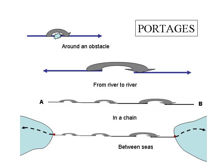
12) Rivers rarely offer an unimpeded passage to boats, and before their improvement by the installation of locks and the dynamiting of obstacles it was often necessary to carry the boat and its goods around a set of rapids, for example. This is a simple portage or Schiffschleppweg. By doing this between rivers (e.g. by carriage across the headwaters of streams flowing in different directions) it was possible in certain areas to travel over considerable distances by boat, even crossing large peninsulae such as that of Europe itself. In early times each segment would have been operated independently, but metropolitan centres such as Constantinople attracted long-distance mercantile expeditions from as far away as the Baltic, travelling in this manner (see title image, at top). Similar networks grew up in Siberia and North America in the early modern period, carrying the fur trade.
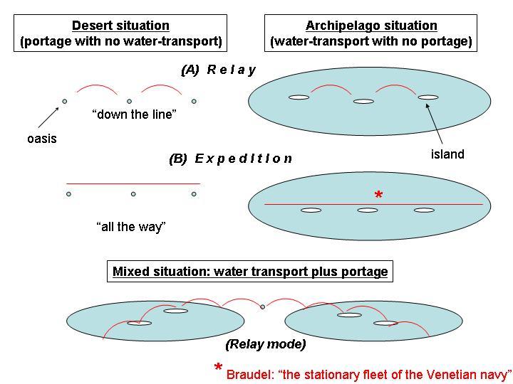
13) This diagram compares long distance routes, (left) across a desert, with scattered oases; and (right) across a body of water strewn with islands. It further contrasts (upper) "relay mode", where the traffic takes place in many different steps between the different segments, and (middle) "all the way", where a single long-distance expedition is involved. Many examples of long-distance routes (lower) have a mixture of both, here in relay mode. The quotation from Braudel (footnote in red) refers to the islands of the central and eastern Mediterranean, which gained a special importance when linked into strategic routes of commerce and defence.
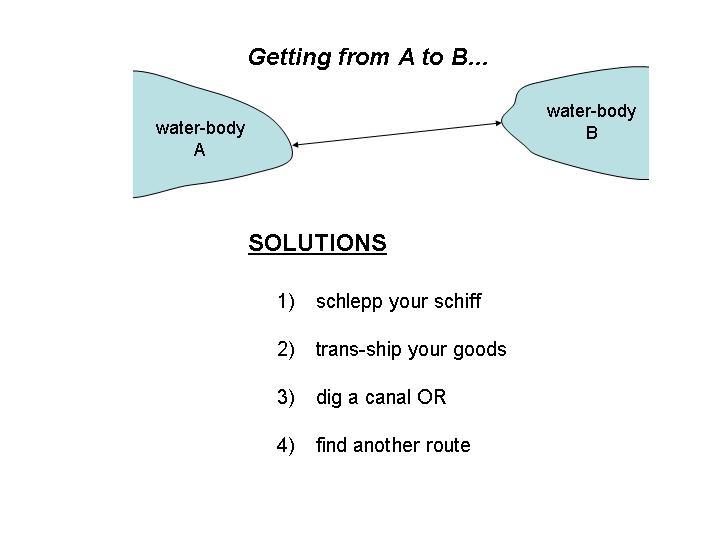
14) Traders using an isthmus (and the inhabitants of such locations) are faced with a characteristic series of choices, which depend on the character of the isthmus, the volume of traffic, and the wealth of the community. (Since the English term "portage" can refer either to carriage of the ship and its goods, or just to the goods, the German term Schiffschleppweg has been adapted for the former!)
15) Here is the set of choices made in a particular instance.
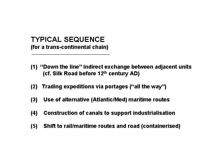
16) Here is a typical set of changes for a chain of portages on a long-distance route.
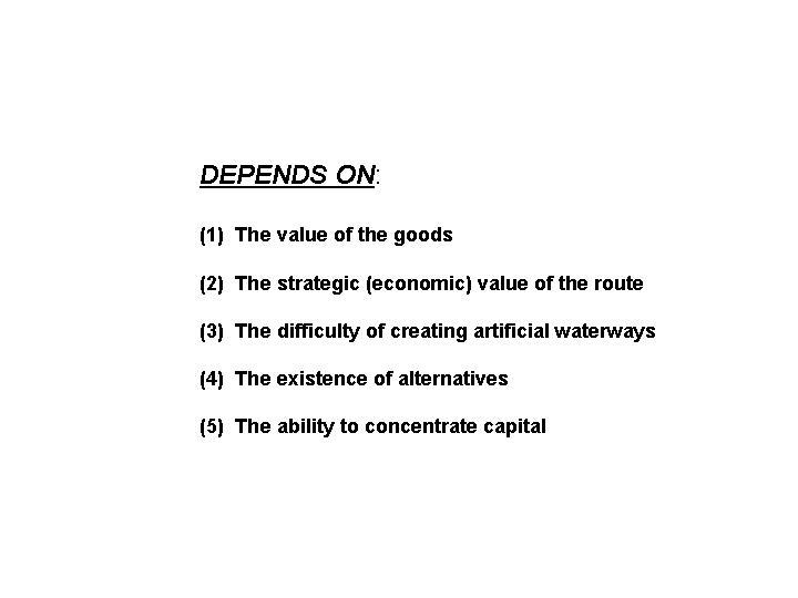
17) And here are some of the factors affecting the choice

This section considers some consistencies in patterns of growth, and in particular the proliferation of "great trans-isthmian" routes extending across the entirety of the European peninsula from north to south, and their changing topological configurations – from a single central axis, to several parallel routes, to a more complex pattern with multiple external connections.
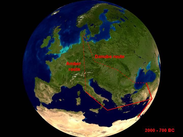
18) The two most famous early long-distance routes across Europe were the Danube route and trans-Alpine Amber route, which formed successive axial routes of communication during the Bronze Age, in the second millennium BC. They developed in relation to the growth of urban communities in the eastern Mediterranean, for whom the Danube was the main axis of contact with inland Europe, supplemented and ultimately replaced by the trans-Alpine route when maritime traffic reached as far as Italy, in the later second millennium BC. (NB: North African routes not shown in these maps.)
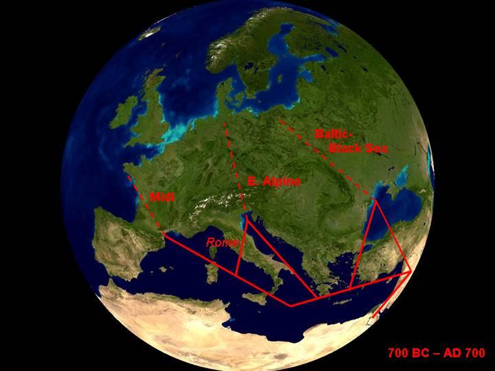
19) In the ancient world, with the economic (and temporary political) unification of the Mediterranean under the Romans, a parallel series of routes connected northern and southern Europe, from the Atlantic to the Black Sea. The most important of these was the axis through western Europe, using the great rivers (Rhone flowing southwards, Loire, Seine, Meuse, Mosel, Rhine, flowing north and west). These carried greater volumes of goods and sustained a degree of urbanisation in Europe beyond the Mediterranean.

20) After AD 700, the earlier axial routes were "outflanked" at either end: to the east by the development of river networks, linking the eastern Baltic to the Black Sea and the Caspian (and so to the northern arm of the Silk Road), and to the west by the linkage of the western Baltic to the North Sea, and ultimately by Atlantic routes reaching as far as the Mediterranean. (These radical changes coincided with a comparable linkup further south, associated with the rise of Islam.) This growing network of connections produced an evolving geometry, which was further transformed by Atlantic expansion, and the discovery of the New World and the route to the Indian Ocean round the tip of Africa.

21) The changing pattern of long-distance routes (varying both because of economic and political factors) affects how units at the edge of the system plug into the wider network. Here are a couple of examples.
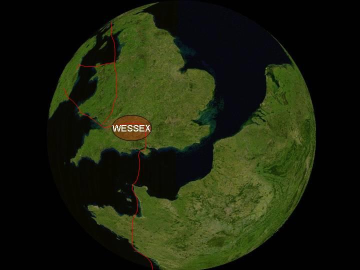
22) By the later first millennium BC, Britain came to be connected with the adjacent continent, and indeed was partly incorporated for a time within the expanding Roman Empire. Before the development of large sailing-ships capable of navigation in Atlantic waters, it was linked to the mainland by two possible routes: due south from the south coast, to Normandy and the Seine, or due east to the Low Countries and the Rhine. This schematic map shows the pattern of connections in the former configuration, focussed on Wessex – the cultural centre in much of the Bronze Age and earlier Iron Age, and later the centre of the Saxon kingdom. (See Space Imaging's gallery of ancient sites including Stonehenge )
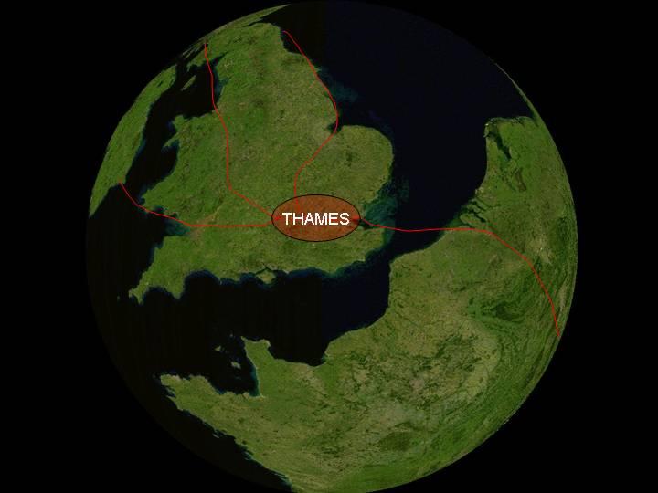
23) In the century before the arrival of the Romans, the alternative configuration developed, shown here in a schematic map. This was oriented towards the Rhineland, with its focus in the Thames basin. This was the setting of the Roman capital of Londinium, and its successors
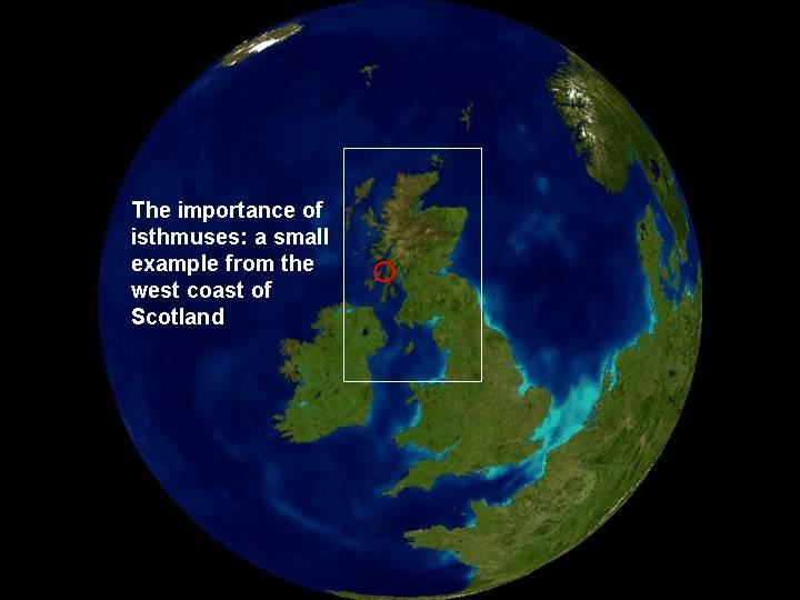
24) Just as the British Isles as an entity was set within the wider context of trans-European routes, so the role of individual regions within it must be understood in relation to the shifting patterns and changing relative importance of internal routes. The west coast of Scotland forms an important north-south connection, between the Northern Isles and the Irish Sea.
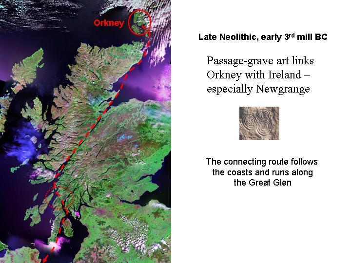
25) Here, the Great Glen, running from SW to NE, forms a major trans-isthmian route across the country; and it was evidently a major axis of contact in Neolithic times, to judge by the cultural connections between Orkney and the lower Boyne valley in Ireland.
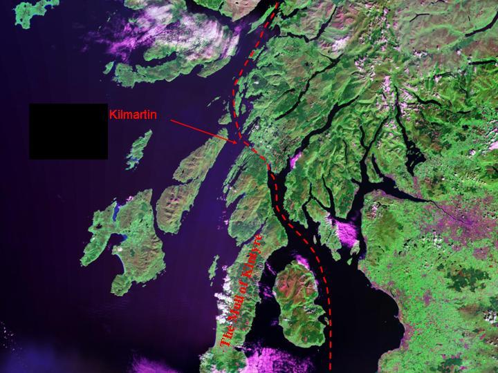
26) To stay in sheltered coastal waters, a further narrow isthmus had to be crossed, at the head of the Kintyre peninsula (now crossed by the Crinan canal); and it is notable that just this area (around Kilmartin, Argyll) has a notable concentration of Neolithic rock art and ritual monuments, at a transition point along this axial contact-route. (It is unlikely that individuals regularly travelled along the length of this route, which probably had the character of a series of directional relays, carrying messages, myths and precious objects and small quantities of valuable commodities – like seal-oil, for instance – along it.)
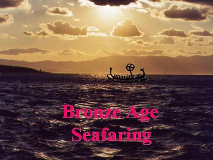
This section looks at the logic of maritime and overland routes in a complex coastal and island environment with relatively small boats and low volumes of traded goods – the conditions under which portages are likely to have been important. The image (a Nordic Bronze Age rock-carving of a ship, carrying a solar disc, superimposed on a maritime scene – actually a view of Chios from the opposite coast!) is intended simply to convey an impression of the scale and relative fragility of shipping at this stage, and not to be taken literally. These conditions would apply to the third and early second millennium in the Aegean, although during the second millennium larger sailing vessels (of the kind represented by the Uluburun wreck) would have plied the arterial routes to Crete along the south coast of Turkey, probably on a circular route down to Egypt and up the Levantine coast.
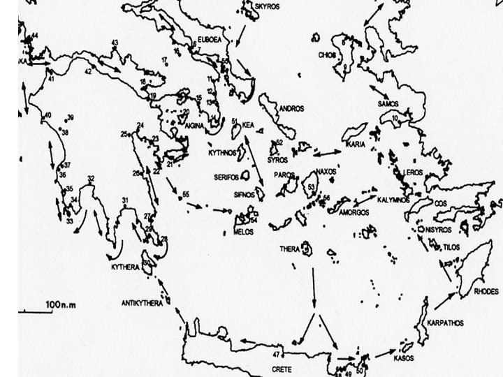
27) Map created by Christos Agouridis and published in the Oxford Journal of Archaeology 16(1): 1-24 (1997), showing Early Bronze Age (third millennium BC) sites in the Aegean, and the pattern of proposed connecting routes discussed in the text of the article, where the numbered sites are listed. Transport at this stage was by canoe, propelled by paddlers and without use of the sail. Note the multiple route segments, crossing between specific objectives in a series of steps.
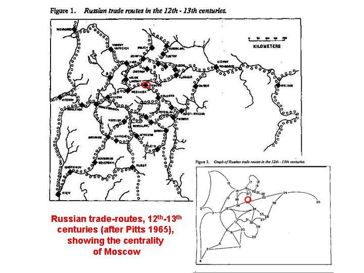
28) For comparison, a classic analysis from 1965 by F.R. Pitts (University of Hawaii) of a segmented route system along rivers in central Russia in the 12th to 13th centuries, using graph theory to demonstrate the centrality of Moscow. For a retrospective assessment of the analysis, see: http://www.analytictech.com/networks/pitts.htm
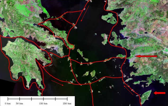
29) Representation of the Aegean maritime route-system for the third millennium BC, joining the route-segments proposed by Agouridis (above), showing the cellular nature of the network. Broad arrows to the right indicate major input-points from further east: the Meander valley and the route along the south Turkish coast.
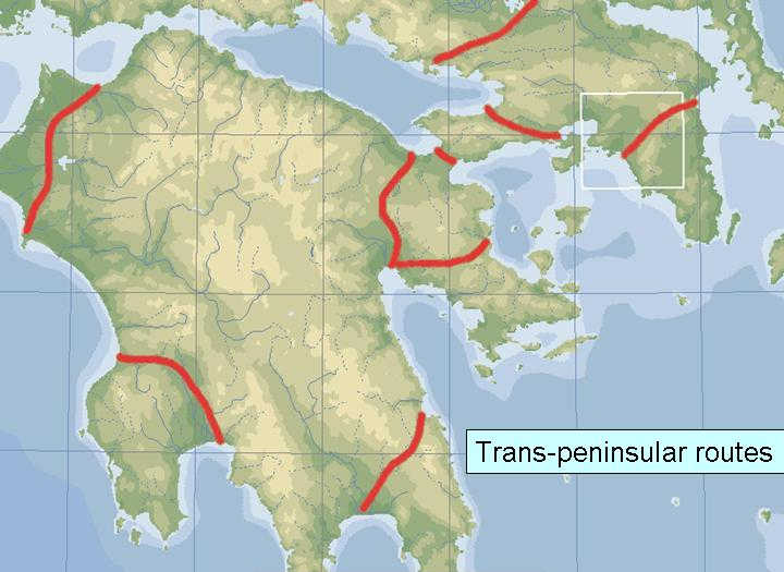
30) Overland routes complementary to the network of maritime connections shown above: the major trans-isthmian and trans-peninsular routes which provide "short-cuts" around major obstacles to maritime traffic.
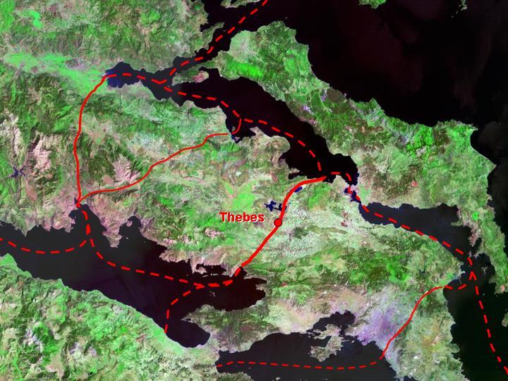
31) The articulation of maritime and overland routes: a suggested pattern for Boiotia, between the Straits of Euripos and the Corinthian Gulf, showing the centrality of Thebes. The island of Euboia to the north; the isthmus of Corinth in the centre at the bottom of the image.
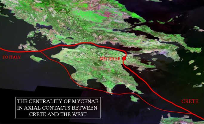
32) The position of Mycenae on the principal route between Crete and the west, via the Corinthian Gulf (the other, outer route, via Messenia, has Pylos as its modal point). This analysis of the location of Mycenae was first proposed by Victor Bérard. (Perspective view).
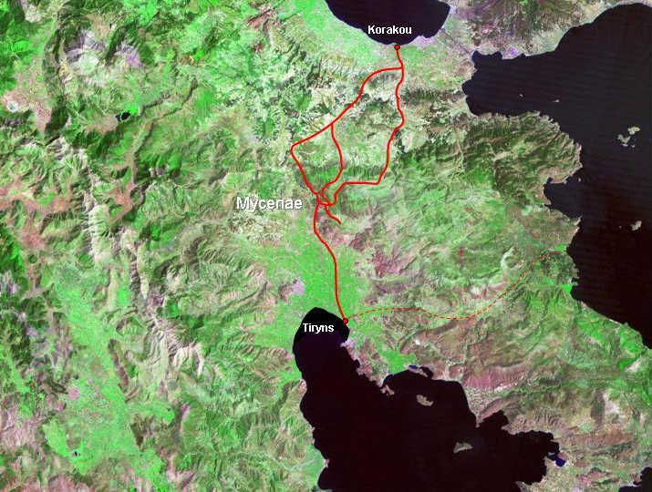
33) The location of Mycenae, controlling the north-south trans-isthmian route between the Gulf of Argos (with the Bronze Age port site of Tiryns) and the Gulf of Corinth (with the Bronze Age site of Korakou), with suggested routes between them (after Wace and Blegen).
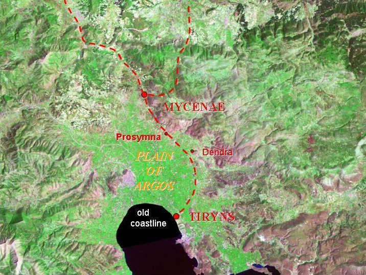
34) The Plain of Argos in Late Bronze Age times (1600-1300 BC), showing the position of Tiryns on the contemporary coast, the intervening fortified sites of Dendra (Midea) and Prosymna along the eastern edges of the Plain, and the dominating position of Mycenae at the head of the Plain, where routes from the north converge.
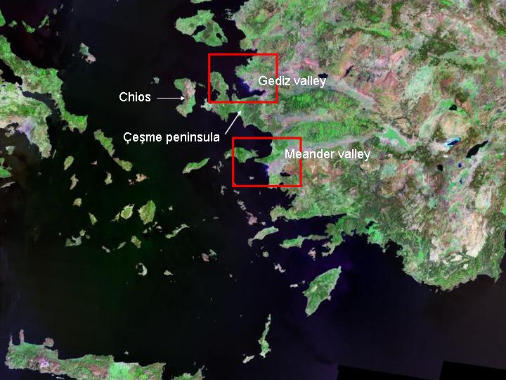
35) The Cyclades and the south-western coast of Anatolia, showing the heavily indented nature of the coastline and the pattern of island connections.
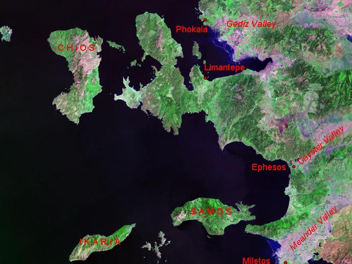
36) The indented coastline of south-west Anatolia, at the outlet of overland routes descending from the plateau. Major Bronze Age sites of Miletos and Ephesos (whose contemporary names of Millawanda and Apasa are known from Hittite records) are shown, as well as the important trans-isthmian site of Limantepe, on the Ceşme peninsula. (The Iron Age site of Phokaia, mother-city to an extensive set of colonies in the west Mediterranean in the sixth century BC, is also shown.)
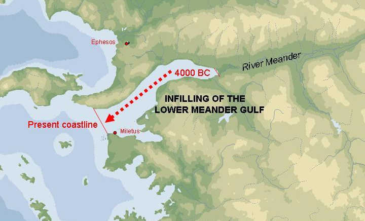
37) The valley of the lower Meander has experienced extensive infilling since later prehistoric times, and during the Bronze Age the coast was well inland of its current position. (Reconstruction based on work by S. Erinç, O. Erol, H. Brückner, B. Bay).
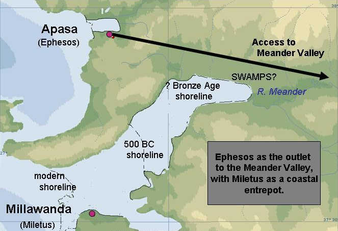
38) The relative roles of Miletos (Millawanda) and Ephesos (Apasa) in the Bronze Age. Miletos, although geographically within the Meander valley, is in a somewhat "offshore" position in relation to it, well situated for external connections along the coast (e.g. to Rhodes) but at some distance from the rivermouth and routes along it. Ephesos, on the other hand, although not within the valley itself, is nevertheless better placed as the principal port with access to the major route along the Meander. Being situated on a much smaller river, it was less subject to alluviation (though its own bay, reconstructed here, was more extensive in ancient times than today). This is a common pattern in the Mediterranean, with its rapidly prograding river-mouths (cf. Marseilles in relation to the Rhone), as Bérard pointed out.
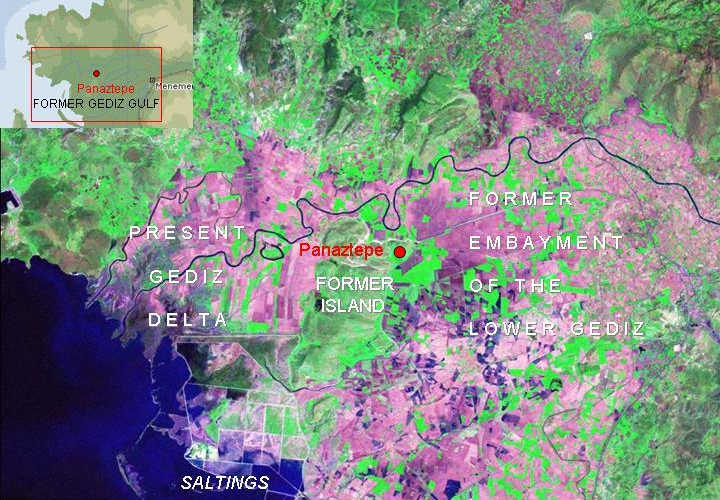
39) A probably rather similar situation obtained, almost in mirror-image to the Meander valley, on the north side of the Ceşme peninsula, at the end of the Gediz valley – the second major inland route linking the Anatolian plateau to the Aegean coast. This, too, has been subject to massive alluviation, although it has not been investigated in the same way as the Lower Meander. The Bronze Age site of Panaztepe is situated on a former island in the Gulf, now a rocky hill rising from the irrigated fields around it. Its "offshore" location suggests a role analogous to that of Miletus.
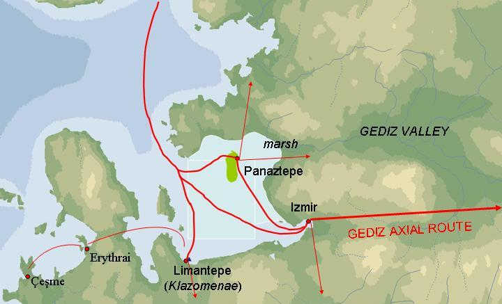
40) As with the Lower Meander valley, the major site with access to the Gediz valley route is not actually in the valley itself, to avoid alluviation. It was probably located near Old Smyrna/modern Izmir, just as Ephesos was displaced from the Meander outlet. It would have linked to a series of maritime routes, some direct and some involving trans-isthmian transfer.
These examples are intended to demonstrate the advantage of simple geographical analyses, taking into account the extent of environmental change, in creating models for early settlement and transport routes, and the need to treat them at a variety of spatial scales.
"; echo"
CREDITS: ;NASA Blue Marble true-colour global imagery (1km resolution): Nos. 7, 8, 9, 10, 19, 20, 21, 23, 24, 25. Landsat TM 5 imagery mosaic provided by NASA: "You may use NASA imagery, video and audio material for educational or informational purposes, including photo collections, textbooks, public exhibits and Internet Web pages." : Nos. 2, 4, 6, 26, 27, 30, 32, 33, 34, 35, 36, 37, 40.