 Occasional Papers (2009-)
 Site Visualisations
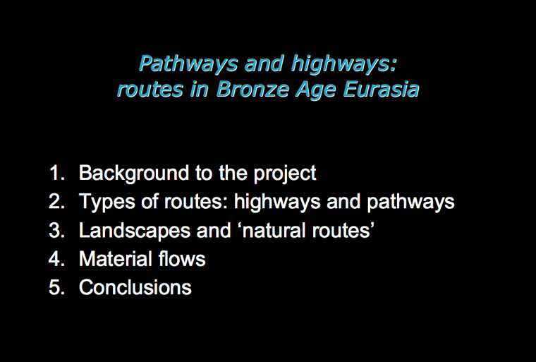
Background to the project
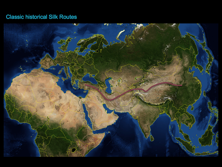
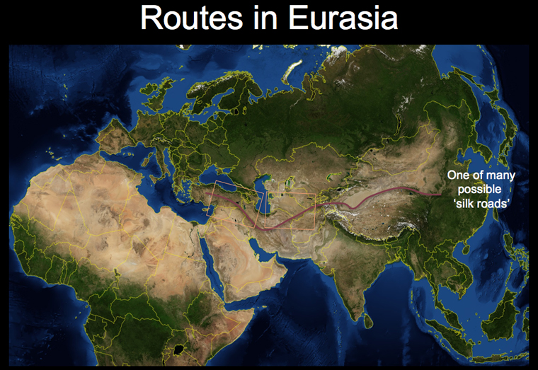
Traditionally, the 'Silk Roads' are said to have 'opened' sometime towards the end of the 1st millennium BC. But what came before the silk routes? How far back can we identify these transcontinental routes of exchange and interaction? These questions, which I could not find easily answered, led me to develop my current doctoral project, to look at the precursors of and the prehistoric predictors for long-distance routes, and networks of exchange, in Eurasia.
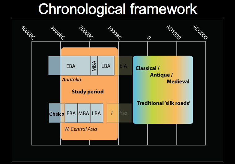
The intention has not been to discover a 'prehistoric silk road', but rather to explore the long-term viability and transformation of exchange route systems in Bronze Age Eurasia. For this reason I have focussed on a period between around 3000 and 1000 BC.
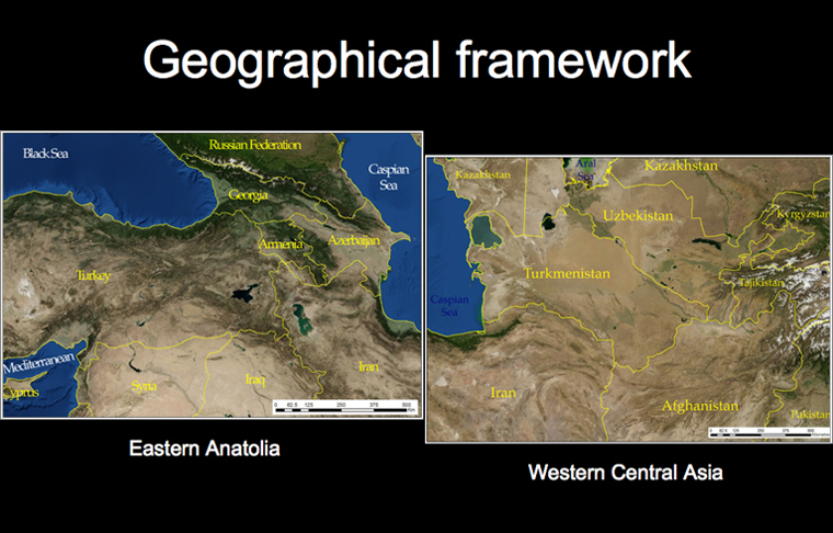
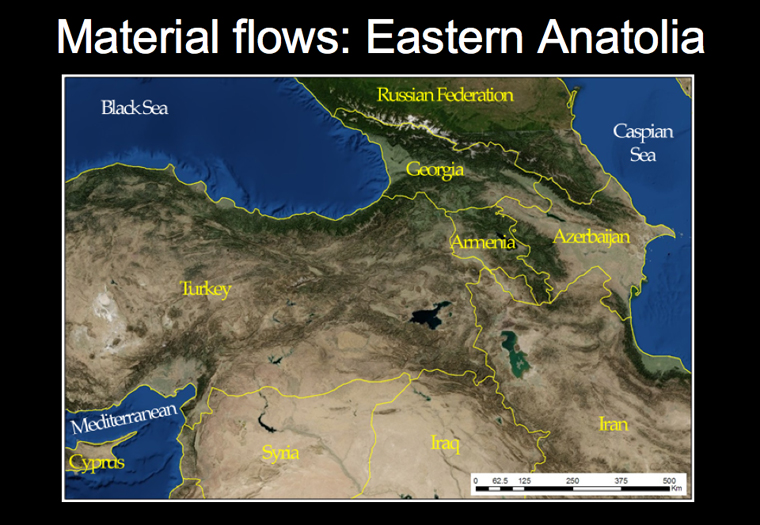
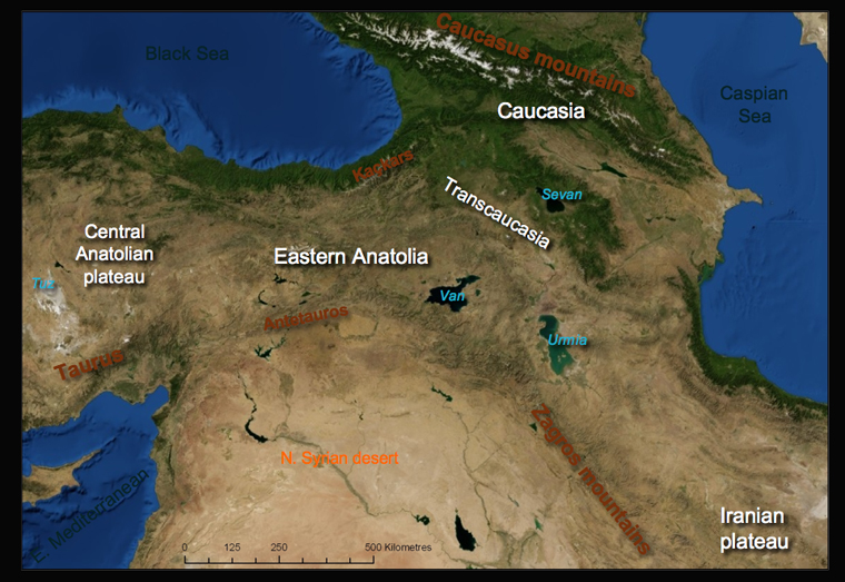
Two case-study regions, Eastern Anatolia and Western Central Asia, form the detailed basis of this project.
Types of routes: highways and pathways
To explore the issues of routes, for the purposes of this paper, I would like to make a distinction between pathways and highways.
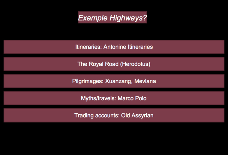
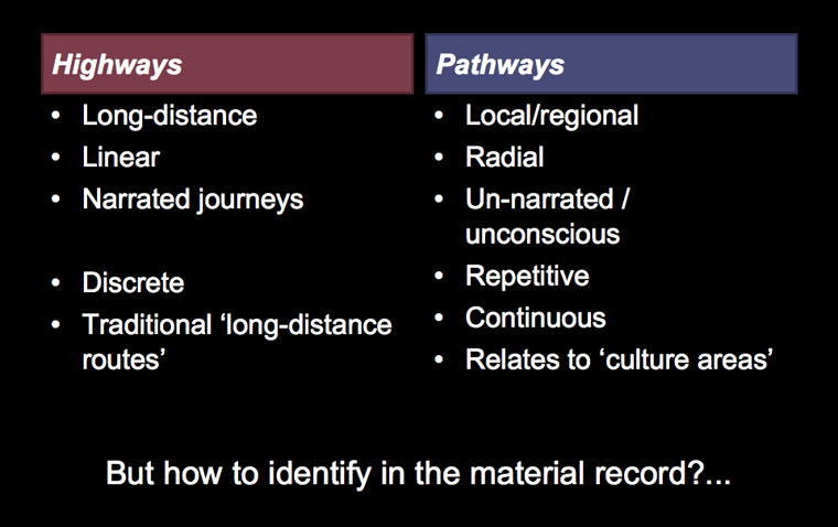
Traditionally in both archaeological and historical accounts, discussions of routes have focussed on reconstructing the location of what I call highways. These types of routes are those which normally may (or may not) be gleaned from historical accounts: official itineraries, for example Antonine Itineraries of the Roman era; stories or records of military/technical success or failure, like Herodotus' approving description of the Persian Royal Roads, or Alexander's conquests of the east (depicted above in the form of a map for modern audiences); pilgrim accounts, such as Chinese monk Xuanzang's personal journey west to India and beyond, or Mevlana's journeys across the Islamic world; fabulous stories, such as Marco Polo's travels east; or trading records, such as the Old Assyrian description of caravan routes between northern Syria and Cappadocia in the 20th century BC. More recently, in the 19th and 20th centuries, European travellers and military officials spent considerable time creating records of similar routes and itineraries, comparing the landscapes they explored against ancient sources.
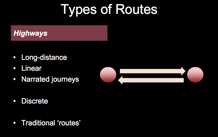
The common feature is the narrative-like structure of the journeys described: accounts of highways are telegraphic, partial and linear. They describe a series of landmarks, or key characters along the way – cities, fords, passes, bridges, or peoples – between an origin and a destination. They often involve significant journeying over long-distances by individuals. Often, though not always, highways are the dominant or 'official' ways by which urban dwellers may pass from major urban centre to other major urban centre. Indeed highways are the means by which the elite travel, or send goods, to parallel elites in other centres. They may be reified physically through the construction of metalled roads, official posting stations, or protected by special guards. All these may come at a cost, as tolls and taxes must be paid to access the advantages of the highway. Highways also may cross cultural or political boundaries, as major interregional 'trade routes'. In this sense, highways are bipolar: having clear start and end poles, each of which potentially occupying very different social spaces.
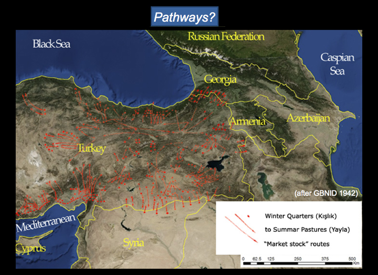
In contrast to highways, there is a second type of route, which I would call pathways. Pathways are related to everyday movements between home, work and other settings for action that rarely get recorded in detail by being written down. They include the footpaths, animal or cart tracks between villages, houses, fields or, in the case of transhumant societies, between pastures and other bases like those seasonal migration routes depicted in the image above.
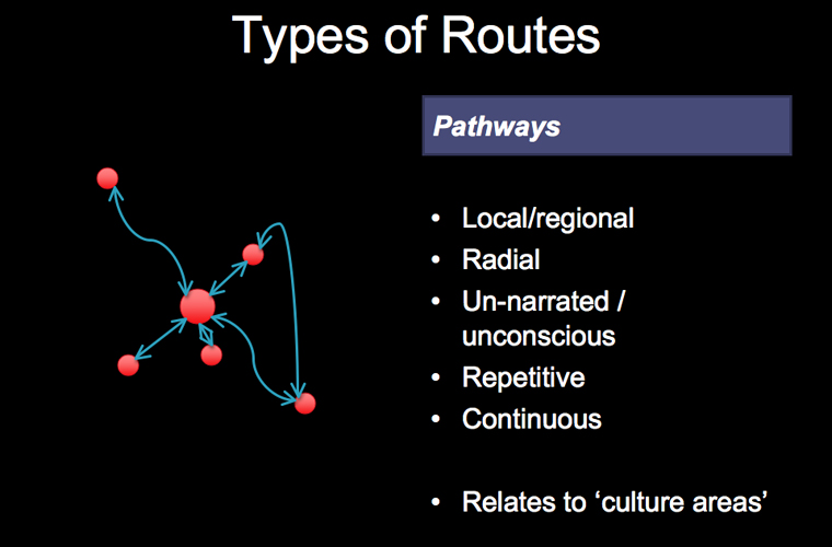
Unlike highways, pathways are radial rather than bipolar, in the sense that they involve repetitive travel back and forth between bases. Cumulative unresolved movements may result in gradual drift over the long term, of course, for example in situations where marriage patterns dictate relocation, or where labour or environmental advantages pull and push segments of population. Pathways are, as the name suggests, smaller than highways, and may sometimes involve subversive or unofficial movements (though probably still socially constrained), such as smuggling. The motivations behind individual selection of pathways are contingent on a local level to ritual, mythical, and personal needs, rather than economic, though cumulatively they are affected by the structure of the landscape.
Can we identify differences between highways and pathways in the material record? What would we expect to see? Actual trodden paths of either kind are very difficult to identify definitively, until, that is, the construction of roads. Ancient tracks may hold broad continuity within a corridor over the long term, but highways and pathways shift location through time, leaving little remains. Whilst the focus of research has tended to be on establishing the past routes of highways; I feel that archaeological evidence is probably better suited to identifying the effects pathways.
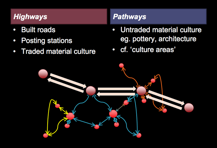
If repetitive small-scale movements create the opportunity for exchange of customs, ideas and gifts; the result in the archaeological record is likely to be areas displaying similar or interrelated cultural practices, or material. In other words, pathways create what has traditionally been identified as the culture area. If, we treat cultures as the result of dense dynamic networks of pathways, and flows of material, ideas and obligations, rather than as reified blocs or essentialist ethnic entities, the cumulative effect of such movements have considerable implications for social change or continuity.
Ancient pathways, then, will manifest themselves archaeologically in the distribution of material such as types of pottery, or architecture. The archaeological imprint of highways, however, may be much more obscure. Particular classes of high-value goods, raw or finished, which are distributed rarely in the material record, provide telegraphic snapshots of the nodes of these routes, but not the links between them.
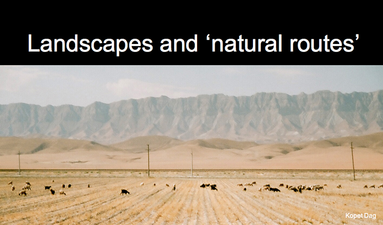
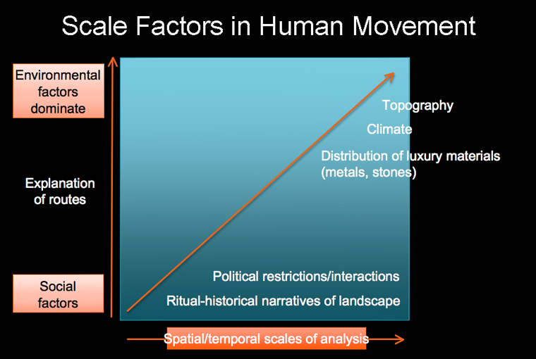
All types of routes of movement are, of course, structured by the specificity of landscape. There are factors of topography, vegetation, water sources and weather that restrict movement. Being able to make sense of varying landscapes on a large-scale, presents particular problems for those interested in understanding long-term shifts in route patterns and their role in societal change.
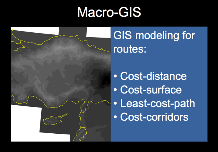
Fortunately, GIS digital mapping and analysis is beginning to make the synthetic task easier, offering tools that can zoom the investigator between scales of analysis. GIS modelling offers the potential to indicate 'natural trade routes' by modelling key features of landscapes that might affect routes.
Using GIS, various variables may be combined to form a unified 'quasi-predictive' model of potential movement, by modelling the relative 'cost' to traverse different areas of terrain. Example variables include:
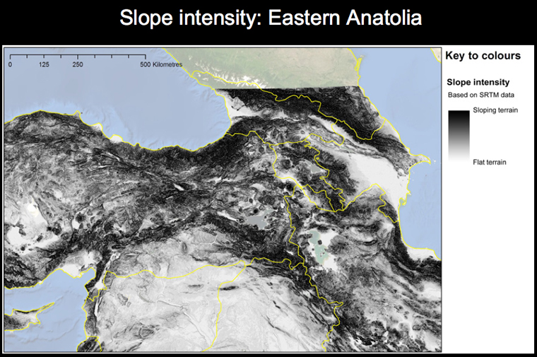
Slope, derived from SRTM topographical Digital Elevation Model (DEM).
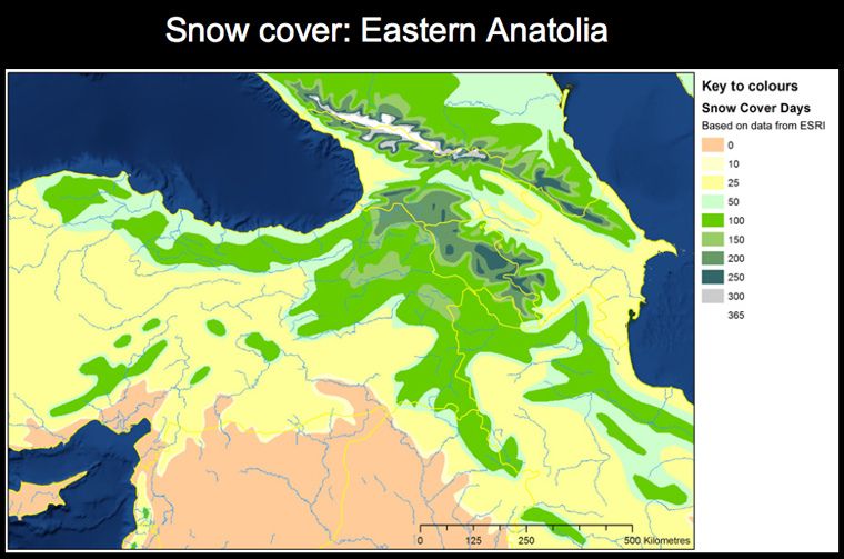
Snow cover, as certain areas become impassable through certain times of the year, here based on ESRI's freely available snow cover dataset.
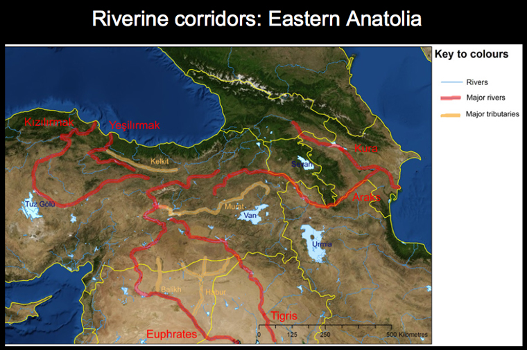
Riverine corridors where rivers favour parallel travel through water transport, but may inhibit perpendicular travel except at nodal cross-points.
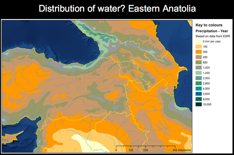
Distribution of water, important for human and animal carriers alike, aquifers and clean water sources are essential to the ability to travel.
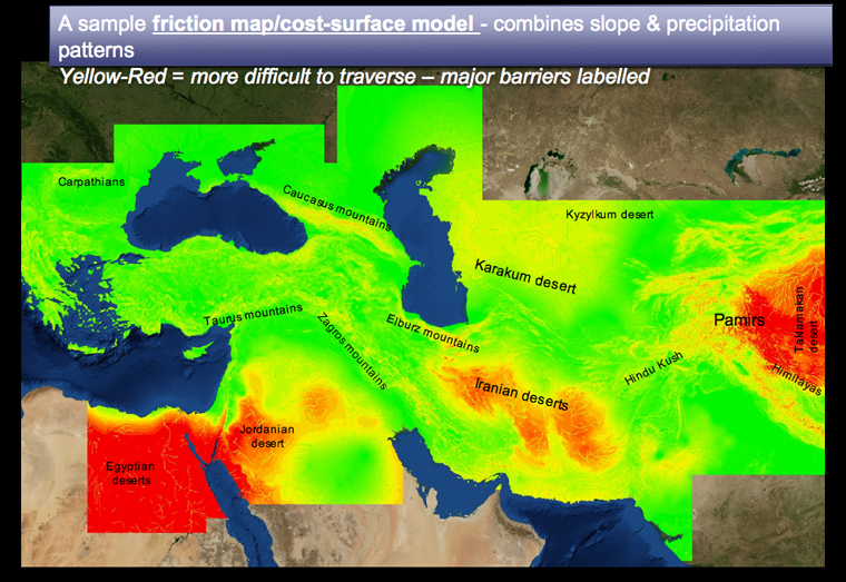
A combined 'cost-surface' (also sometimes known as a 'friction map') gives a general indicator of the ease or difficulty of crossing particular terrains. It is unlikely that there is a single formula that would provide us with a universal model of 'natural routes' of travel, however: rather the process of putting these variables into to a formula allows us to be explicit about our expectations and assumptions of routes, whilst looking at the detailed specificity of the landscape.
If pathways are made up of repeated, small movements, then we want to be able to visualise the cumulative result of these small movements between settlements and resource centres. It is this long-term accumulation that we may also be able to identify in the archaeological record, through the distribution of objects.
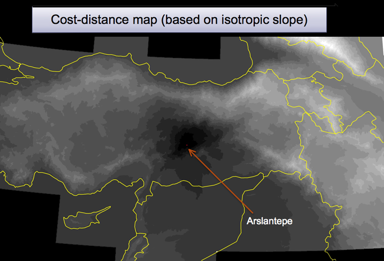
The use of cumulative cost distances appears to be one way to help to visualise the density of networks of pathways in a more dynamic way. A 'cost-distance' map, like this one (above) based on Arslantepe, shows the relative distance away from the site, when taking into account key variables (for simplicity in this instance, the same slope-based friction map, as shown in the previous image) as an impediment to travel. It thus gives a rough bidirectional sphere of influence and likely range of movement to/from the site to surrounding locations.
 A model of cost-distance and cumulative cost-distance is still being developed. In the analyses below, a sample of Simple Cost Distance surfaces have been created to illustrate the relationship between the specific landscape and particular material forms, by showing the relative distance away of each point to the nearest node. Topography and distribution of water (particularly precipitation) have been included in the base friction surface. As well as including more variables, a more complex analysis could also take into account (1) the percentage of the material found at the node that can be assigned the typological category in question, (2) the total size of the site or material, (3) the cumulative effect of the distance beyond each individual node (not simply the nearest node).
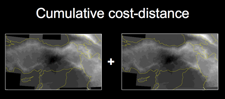
If you combine multiple 'cost-distance' maps together (into a cumulative cost distance), each with different origin nodes, the resultant map begins to show density patterns, which indicates the density of pathways between nodes. For each object type, cultural zone, or other features, the cumulative cost-distance will have a distinctive signature, allowing comparison between periods and object.
This technique allows the researcher to more easily visualise the relationship between objects distributions and landscapes, and hence the interrelationships across space and pathways.
It is often said that routes tend to remain in use for long periods of time. This is undoubtedly true, because of the stable structure of landscape. However, the density of routes changes through time, as materials and people flow in different amounts at different times along these 'natural routes'. Whilst the understanding of the landscape may show potential travel routes, detailed knowledge of the material record is also required to reconstruct actual prehistoric flows. But which materials are best studied?
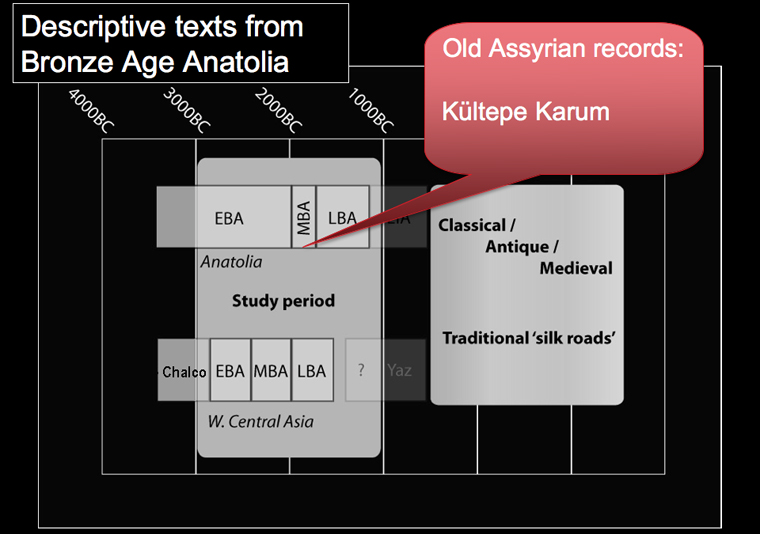
There is little direct textual material for either of my case-study regions: an exception from Anatolia is the Assyrian karum records from Kültepe dated to around the 19th century BC (Larson 1967; Derckson 1996). If the indications from these Assyrian texts are any sort of guide to wider trends in exchange patterns across the 3rd and 2nd millennium, then there were probably two main classes of objects that dominated exchange patterns: metals and textiles. It is ironic that direct examples of both are badly represented in the material record: metals because of their contradictory role as high value items and medium of exchange, and textiles because of the rapid deterioration of the materials themselves.
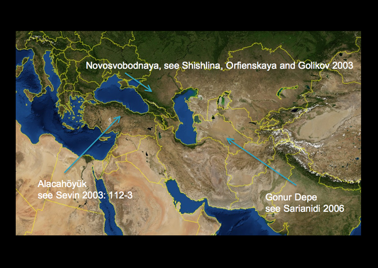
Brief snapshots of metal types may be gleaned from, for example, the deposition of metal objects in hoards, or richly-furnished tombs, common in Anatolia and the Caucasus in the late 3rd millennium BC, eg. at Alacahöyük.
Similar deposits of metals are also found in parts of Western Central Asia, including Bactria-Margiana in the early 2nd millennium BC, eg. at Gonur Depe (Sarianidi 2006).
Real textiles, perhaps imported, have been found in mid-4th millennium graves in northern Caucasia (Shishlina et al. 2003), but are generally better represented by burials in the desiccating climates of Egypt or, later, the Tarim basin. In both eastern Anatolian and western Central Asian regions, direct examples are scarce.
Given the low level of archaeological visibility of metals and textiles, how can we trace their flows? One form of indirect or proxy evidence comes from ceramics.
Pottery may sometimes be ignored in the discussion of routes; partly because pottery itself is rarely transported over long-distances until maritime travel made it practical or desirable. Pottery styles are often considered aspects of local identities. However, the tendency for pottery to echo shapes and patterns of other more valuable materials, just as plastic today echos precious stone jewellery, or wooden surfaces on furniture, its skeuomorphic plasticity allows it to act as a proxy indicator (cf. Vickers 1989).
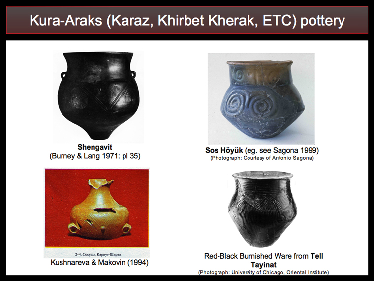
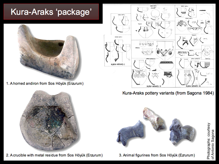
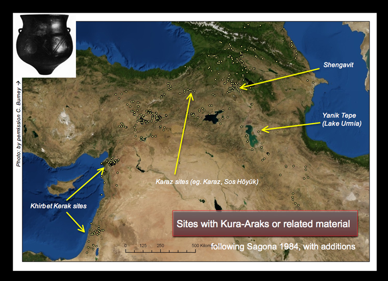
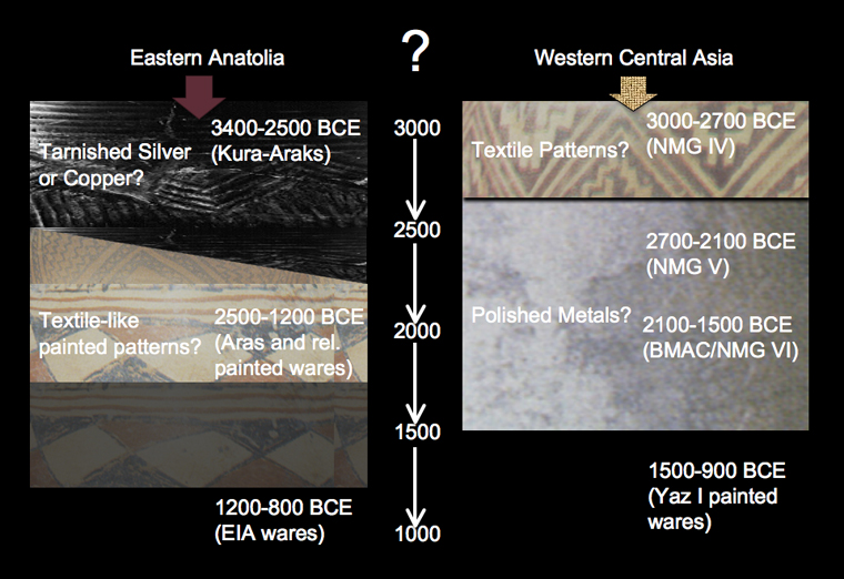
In Eastern Anatolia, the material record is dominated from the late 4th to the mid-3rd millennium BC, by a phenomenon known variously as Kura-Araks, Kuro-Arax, Early Trancaucasian, Red-Black Burnished Ware, or Khirbet-Kerak (eg. Sagona 1984; Philip 1999; de Miroschedji 2000; Rothman 2003; Summers 2004). This distinctive assemblage primarily based on pottery, first appears around 3400 BC in Transcaucasia, and its distribution quickly extends to wider Eastern Anatolia, Western Iran, and the upper Euphrates; and later, similar wares (Red-Black Burnished Ware and Khirbet Kerak) are also found in certain areas of the Levant.
There are several chronological developments and sub-regional characteristics to the pottery, apparently made locally, and not traded over long distances, but the main characteristics, the result of particular technological choices, are dark/black and red burnished vessels with incised decorations.
Importantly, these vessels recall metalwork, suggesting the emulation of tarnished silver or, given the red tones, copper-based vessels. At the very least, they suggest the primacy of a 'metal aesthetic' in which the dual tones of a dark matte-gloss of certain intentionally tarnished, or aged, metals (rather different to the modern 'shiny' aesthetic which is associated with silver or steel when 'cleaned'), and a shiny bright copper red, forms a basis for value and material desirability.
The landscape of Eastern Anatolia and Transcaucasia is defined by high-mountains with few passes, and discrete areas of flat land, mostly along river valleys, in which agriculture may be undertaken; and wide areas of highland pasture.
echo"
The distribution of Kura-Araks (the state knowledge as of 1984, shown above: more sites have been identified since then) hugs this highland fringe of the north Mesopotamian region, and it seems likely that a relationship of interaction between the urbanising north Mesopotamian plain, and the highlands of Eastern Anatolia is therefore important.
";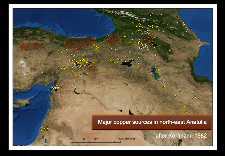
The obvious basis of this relationship has long been identified as metal exchange, as copper, gold and silver sources are in abundance across the mountainous east of Anatolia.

Using the techniques of cost-distance outlined above, this simple experiment, uses the distribution of excavated Kura-Araks sites to show local groupings, and indicates the signature of the low-level potential interaction zone between sites.
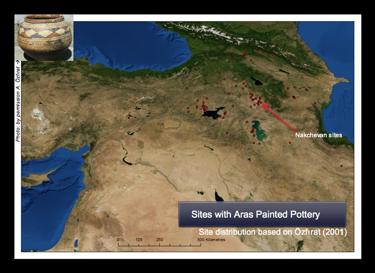
Eastern Anatolia underwent significant transformations sometime after the mid-3rd millennium BC. The evidence is complex and confusing, but in the many regions, many former Kura-Araks settlements fall into disuse or show minimal occupation (Özfırat 2006). Instead, evidence from late Early Bronze, Middle and Late Bronze ages of far Eastern Anatolia and Transcaucasia mostly comes from burials, such as the Bedeni or Trialeti groups, which are located in highland pastures.
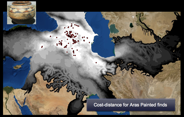
The sample cost-distance above uses the distribution of Aras Wares as described by Özfırat (2001).a class of painted pottery which begins to appear in cemeteries and sites from parts of the former Kura-Araks region, in some areas replacing the dark burnished/polished wares so characteristic of the Kura-Araks period (Kushnereva 1997: 81-149).
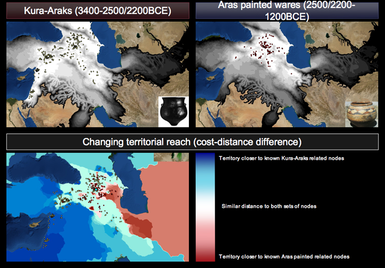
A comparison actually shows similar local groupings to the previous Kura-Araks period (a result mainly of the discrete mountain valleys of the region), but the density of the interaction zone has shifted to a smaller scale, and to the east. More research will be needed to know whether this is an artefact of differential research and publication (eg. simply more knowledge about the MBA in Azerbaijan in this model), an artefact of the interpretative resolution, or else a real fact of the distribution of sites and links between them.
The difficulty in identifying Middle and Late Bronze Age settlements in Eastern Anatolia & Transcaucasia has commonly been taken to indicate a shift to a more mobile pastural economy, related either to an in-migration of mobile peoples from the north of the Caucasus who brought pastoralism and their tradition of kurgan construction, or environmental transformations that made the previous Kura-Araks mixed agricultural system unsustainable.
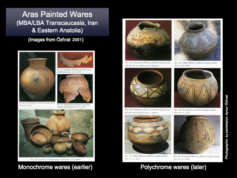
Perhaps more interestingly, the shift in settlement pattern is also associated with a change in material culture. In the northern areas, some metallic-inspired dark burnished wares (like the Kura-Araks) continue in the form of Martkopi or Trialeti wares (with incised patterns), but in the south they become rarer and instead the pottery repertoire is dominated by a variety of local painted wares, such as the monochrome and polychrome Aras wares depicted above (Özfırat 2001). Similar pottery types, known variously as Aras Painted Ware, Sevan-Uzerlik, Van-Urmia, Karmirberd and Kizylvank wares, are found across the Transcaucasian/East Anatolia region (Sagona 2006: 64-66). Different, but perhaps related 'netting' and 'carpet-like' patterns can be seen on both burnished and painted wares. The chronology is complex and uncertain, however, particularly because of the dominance of burial contexts, except for places such as the settlements of Nakhechevan (Bakhshaliyev and Marro 2009).
The full painted pottery zone actually stretches across a vast distance, from Western Iran, across the Transcaucasian area and into the Malatya-Elazig regions, where Gelinciktepe or Malatya-Elazig, Upper Euphrates painted wares prdominate (Marro 1997), and even further west, in Central Anatolia, in the form of Alisar III or Cappadocian Wares (cf. Öktü 1973). Again however, the relative chronologies are poorly understood, and need more analysis, as does the relationship with Iranian painted wares such as those in the Sialk sequence.
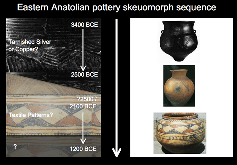
The polychrome 'Aras wares' strongly recall geometric patterns which are often associated with textiles or basketry, rather than metals. The significance of this shift from pottery that emulates a metallic aesthetic through burnishing, to polychromatic painted traditions that have far more in common with textile patterns, is a particularly striking one, but one which is too often assigned an over-simplistic 'ethnic' character.
Tentatively we could suggest that this shift might instead indicate a number of possible changes including (1) a shift in the routes of material flow, especially metals away from this region towards more westerly sources, and/or (2) a fundamental socio-technological transformation of the entire region, in which the aesthetic value and notions of identity are re-orientated away from metals (and flows of metal or metallic objects), towards the medium of textiles (and flows of cloth or patterns). Support for this idea may come from Mesopotamia, where it is said that true polychromatic textiles first appeared in the Near East gradually from the mid to late 3rd millennium (Barber 1991), and wool-gathering and textile production seem to have formed a major industry from at least the Ur III period (Potts 1997: 91-92).
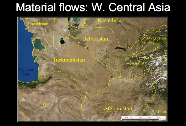
The landscape of western Central Asia and north-eastern Iran, an area sometimes known as 'Turan', is very different to Eastern Anatolia.
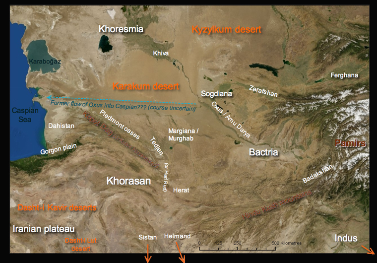
It is dominated by the presence of the Karakum desert to the north, the Dasht-i Kavir in the west, and the mountainous stretch which reaches west to east, from near the Caspian across the Kopet Dag to the peaks of the Hindu Kush and Pamirs.
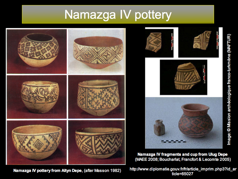
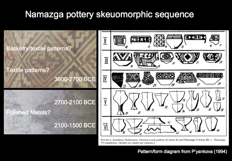
The early 3rd millennium is characterized by the distribution of so-called painted Namazga IV pottery, based on the typology from Namazga Depe in southern Turkmenistan (see Kohl 1984 for broad summary). This pottery, which follows from a long Chalcolithic/Eneolithic tradition of painted pottery in the region, is decorated with striking monochromatic geometric patterns, and occasional stylized zoomorphic figures.
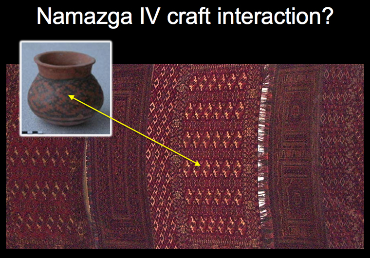
The similarity to the decorative styles to geometric woven patterns, has been often been noted, and is perhaps more striking than the Eastern Anatolian/Aras painted wares. The geometric painted patterns (from across the Namazga I-IV period) are also seen in other materials and contexts, such as in wall-paintings at Yassi Depe (see Hiebert et al. 2003: 20).
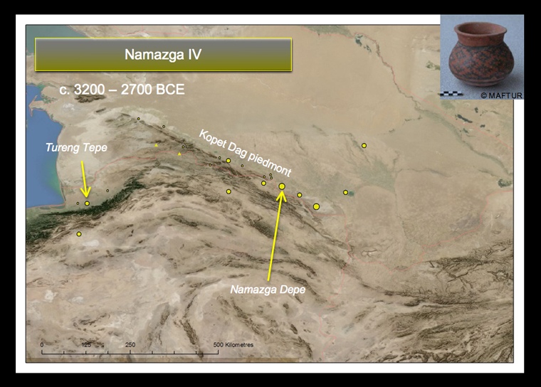
Sites with this Namazga IV material are mostly distributed along the piedmont zone north of the Kopet Dag mountains, in modern-day south-west Turkmenistan, although a few sites from the Iranian side of the mountains suggest that our limited knowledge of material from this country may be masking the full extent of the distribution.
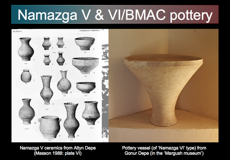
In the mid-3rd millennium, the painted pottery is suddenly replaced by wheel-made plain wares of Namazga V. The production of this plain, slipped pottery continues into the following Namazga VI, or BMAC period, upto the mid-2nd millennium BC. The rejection of the painted tradition has been previously explained as a consequence of mass-production interrelated with the evolutionary advances of wheel-made pottery.
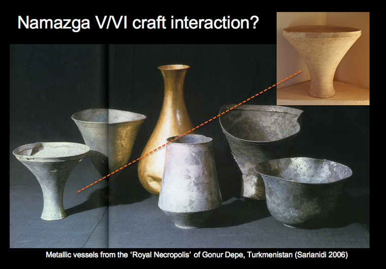
But the overall appearance and feel of the yellow to red slipped wares, and example metal vessels from burials, suggest that these unpainted styles were based directly on metallic prototypes, or simply a metallic aesthetic.
Though copper was known in the previous Namazga IV period, it is not until Namazga V, the beginning of the 'Early Bronze Age' around 2700BC, that the west Central Asian equivalent of metallschock had an effect of pottery production. In this case, it seems that a polished, rather than tarnished, metallic aesthetic was more valued.
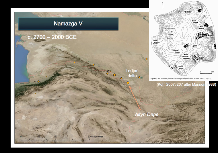
At this time (the 'Middle Bronze Age'), the tell settlements of Altyn Depe and Namazga Depe were at their greatest extent, as proto-urban settlements (Masson 1988; Masson 1992).
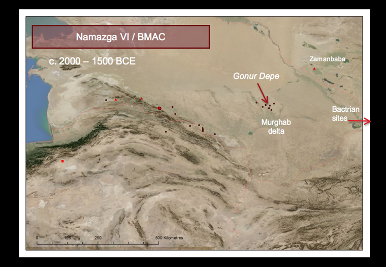
Later, at the beginning of the 2nd millennium, the Late Bronze Age or Namazga VI period, the focus of settlement appears to shift towards the east: to more intensive occupation of the Murghab delta, and Bactria. The distinctive nature of architecture and material culture of this period, led Russian archaeologist Victor Sarianidi, to coin the term BMAC or 'Bactro-Margiana Archaeological Complex' (cf. Hiebert 1994). Sites along Kopet Dag piedmont seem to be much less intensively occupied, if at all; whilst many of the large sites in the Murghab and Bactria appear to be quite heavily fortified.
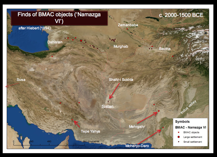
BMAC objects have been found at great distance from the supposed Central Asian core zone, often apparently as intrusive elements in mortuary contexts (Hiebert 1998).
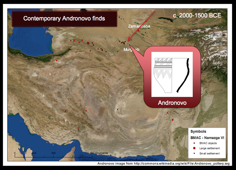
Also interesting is the contemporary appearance, in the oasis sites of the Murghab, of small amounts of Andronovo material, a class of hand-made pottery that is found over a huge area of northern and eastern Asia, with variants linking China with Europe across the Eurasian steppes (Cattani 2008).
The Murghab delta is surrounded by the desert of the Karakum, whose traversal is hard work at the best of times. Travel throughout the region is reliant to great degree on methods of overcoming long journeys without regular water sources. Models of camels pulling four-wheel carts (above right) are known from the previous Namazga V period at Altyn Depe, and camels must have played a part in this prehistoric period as they did in later transcontinental Silk Routes.
As with Eastern Anatolia, explanations for cultural change based on shifts in the environment and or expansive migrations have been put forward for the material and settlement transformations.
But it is also possible to suggest that these transformations result from a change in the direction, nature or significance of flow in material resources. Both the aesthetics of the pottery from Namazga V, and the later shifting settlement pattern from Namazga VI/BMAC, hint at a newly established importance of metal flows after the mid-3rd millennium BC.
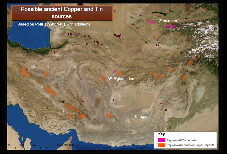
Ancient tin mines, with evidence of exploitation by contemporary Andronovo groups probably in the early-mid 2nd millenium, have been identified in the Zerafshan region, to the north-east (Parzinger and Boroffka 2003); and previous work suggested Afghanistan may have been a major source of tin in antiquity (Cleuziou and Berthoud 1982).
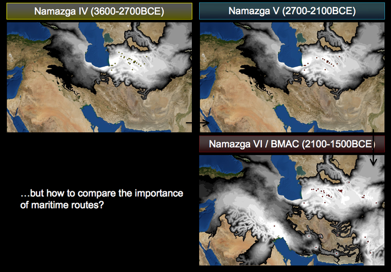
The simple Cost-distances shown here are those for Namazga IV, V and VI respectively. The image for Namazga VI perhaps gives an overemphasis on the link to Mesopotamia based on the few finds of Bactrian metalwork at Susa. All three highlight the difficulty of the southern connection between Mesopotamia and Central Asia, especially without recourse to maritime activity in Gulf. Given the particular model used, the surprising suggestion is that it is much easier to travel east-west around the Caspian into Eastern Anatolia than to travel south over the hills to the Indus or northwards to Khoresmia.
Conclusions
The Old Assyrian trading records suggest that tin imported into Kültepe/Kanesh in the early 2nd millennium, comes from somewhere in 'the east'. This is often interpreted to mean Afghanistan or Iran, linking the Namazga and Anatolian landscapes over huge distances though under many different potential inter-mediators.
Given the rather vague or contested nature of the currently available chronologies, the fact that Central Asian pottery becomes 'metallic' somewhat in the mid third millennium BC, as Eastern Anatolian pottery starts to become 'textile-like' is an intriguing and suggestive possibility, but one which requires further investigation to be fully understood. (The Eastern Anatolian 'painted wares' may be pushed forward to around 2100BCE, for example, and the Namazga chronologies still remain contested, both would have somewhat different consequences for the interpretation of apparent 'synchronisms' or 'anti-synchronisms'.)
Nevertheless, both Eastern Anatolia and Western Central Asia experienced substantial cultural transformations during the period 3000-1000BC, and by comparing the landscape to particular material networks, especially ones that highlight important flows of material (such as metal or textiles), hinted at in other materials, it is possible to start to build a macro-scale picture of the importance of routes, and their changing dynamics over 2000 years whilst paying close attention to the landscapes involved.
The traceable material networks, traditionally described as 'cultures' may have been created by everyday exchange, along local pathways, and repetitive interaction; but interaction at the macro-level suggests that both the pathways themselves, and certain high-value materials, may have been integral in and constructive of material 'highways' of exchange at a trans-regional or later trans-continental scale.
";
The two regions described here later went on to form important parts of east-west caravan routes, particularly in the Medieval / Islamic period.
The 'Silk Roads' are often described as connecting the eastern and western poles of Eurasia. This bipolar identity sometimes obscures the smaller networks of exchange, those local pathways of interaction that underpinned this connection. In the Bronze Age, the problem has been the opposite, where localised cultural patterns and more often disciplinary specialism have sometimes downplayed the nature of interregional exchange, and highways between regions have become lost in the keyhole nature of the data, or assumed to have remained the same through time.
Combining different strands of evidence, and different technical approaches to modelling landscape can help to reveal the different levels of routes and their effects.
Whilst highways have been more intensively studied in the past, it is the combination of movement along both long-distance and small-scale networks, both highways and pathways, which together must have been instrumental in trade, exchange and the transformation of human societies across Eurasia.
Acknowledgements and thanks
I would very much like to thank all those who presented or attended the workshop in April 2009 – they made it a very productive and enjoyable event. I'm heavily indebted to Sue Sherratt for her supervisory support and constant source of ideas and inspiration, and also for her hard work in organising the workshop. Hearty thanks must go to Debi Harlan for the transfer of this presentation to web format and general improvements to ArchAtlas for version 4. Thanks must also go to those individuals or organisations who have given permission for me to use their images here, been kind enough to send me photographs of their own, or else commented on early drafts of the paper: Nadezhda Dubova, Philip Kohl, Olivier Lecomte, Aynur Özfırat, Tony Sagona, Victor Sarianidi, Geoffrey Summers, Anja Slawisch, and the Oriental Institute, Chicago. Financial support for different parts of the research upon which this essay is based was received from the University of Sheffield, the British Institute at Ankara, and Koç University's Research Center for Anatolian Civilizations. Any mistakes or misinterpretations, of course, remain my own responsibility.
Finally this visual essay is dedicated to Andrew Sherratt, without whose enthusiasm and support, I would never have continued down the fascinating path of prehistory and maps.
Note on Images
Appropriate permissions have been sought for the use of images shown in the presentations, and credits are indicated in the text and images above, though it was not always possible to contact those responsible. Please contact the ArchAtlas editor via email if there are any problems with the above images: archatlas@sheffield.ac.uk.
Archaeological sites/project websites
- Margiana Project (Margiana Archaeological Expedition, Gonur Depe): http://www.margiana.su
- Mission archéologique franco-turkmène / MAFTUR (Ulug Depe): http://www.guimet.fr/La-mission-archeologique-Franco