 Occasional Papers (2009-)
 Site Visualisations
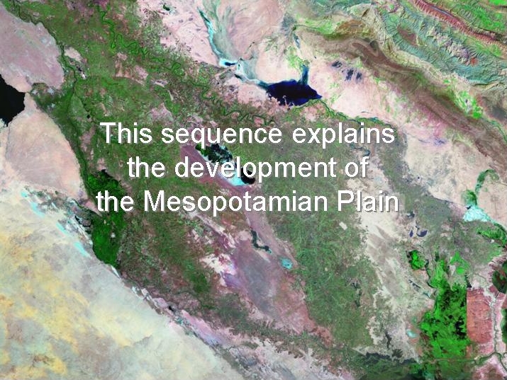
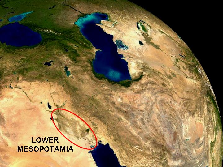
1) Mesopotamia is a trench in front of the Zagros mountains, partly occupied by the sea and gradually being infilled by sediments brought down by the Tigris and Euphrates rivers.
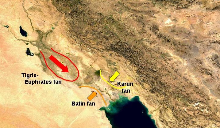
2) In addition to this longitudinal infilling, there is lateral infilling from either side: from the south, a fan created under conditions of higher rainfall than at present by sediment from the the Wadi Batin, and from the north by the buildup of sediment brought from the Zagros by the Karun and Karkeh rivers, which have a single outlet through a range of low hills near modern Ahwaz.
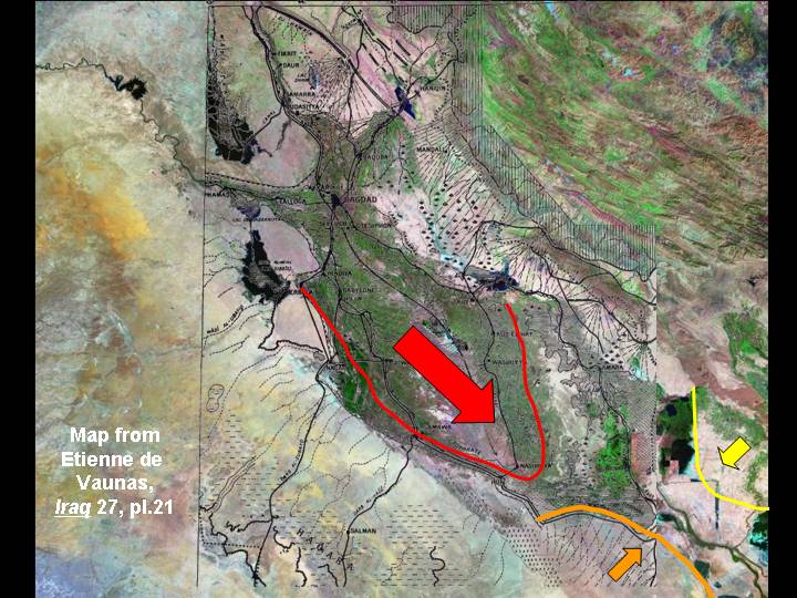
3) Together with the smaller fans along the edge of the Zagros, these determine the shape of the Lower Mesopotamian Plain. The very low gradient along the longitudinal axis of the Plain below Baghdad creates an unusual landscape in which the rivers run in unstable courses between levees which are above the level of the plain. Frequent changes of course take place as sediment accumulates, displacing the rivers into new courses.
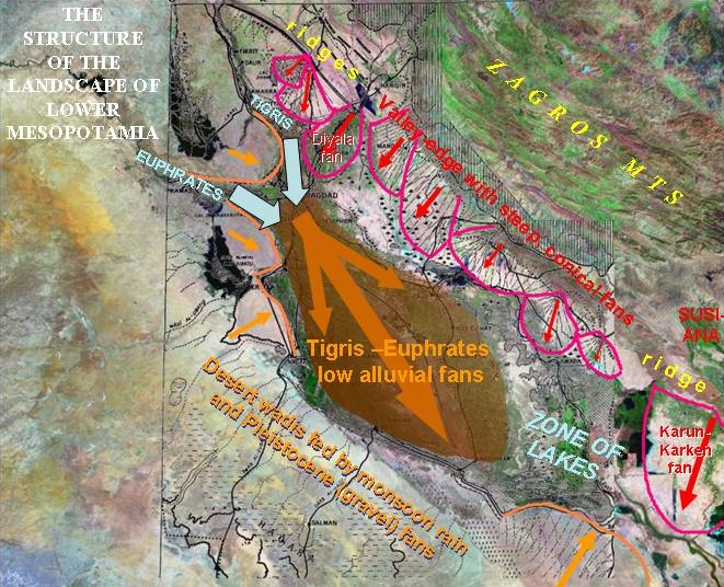
4) The various components of the Mesopotamian lower landscape can thus be summarised in the diagram above.
5) The combination of shifting courses of rivers on the Tigris-Euphrates apron, and the constriction effect of the two lateral fans, has created a zone of lakes and marshes, ponded up behind the growing Karun-Karkeh fan. In earlier times, however, the sea penetrated further north than this constriction, to the edges of the Tigris-Euphrates apron.
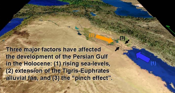
6) The situation at different times in the past has been determined by the balance of these three dynamic processes: rising sea-levels in the post-glacial period, reaching a maximum around 4000 BC; accumulation of Tigris-Euphrates sediment and the infilling of the upper part of the gulf; and the pinch effect created by the progradation of the Karun-Karkeh delta, gradually restricting the outlet to the Gulf for Tigris-Euphrates waters and creating the present zone of lakes and marshes.
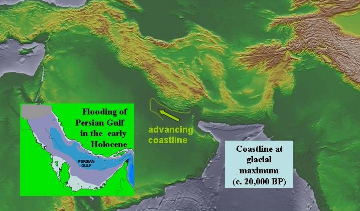
7) During the last glacial period, when world sea-levels were lowered by up to 100 m, the entire area of the present Gulf was above se-level, and would have been a dry area watered only by the restricted flow of the major rivers flowing into it. With the melting of the continental ice-caps at the end of the glaciation, sea-levels slowly rose to occupy the floor of the present Gulf. At the same time, increased monsoonal rainfall increased river-flow, creating more attractive landscapes for human occupation along the rivers, with the increased biological productivity of estuarine habitats. Both of these sets of conditions, rising sea-levels and strong monsoon rainfall, came to an end during the fifth millennium BC. After this time, the infilling processes, and consequent shifts of river-courses, became the dominant factors in landscape formation.

8) The situation at the time of maximum sea-level and before major infilling may be envisaged roughly as indicated in the above reconstruction, with a major lobe of Tigris-Euphrates sediment extending down the southern edge of Gulf, trapping the basin now followed by the Euphrates which was probably an area of lakes and marshes, and with considerable areas of open sea to the north. (The colours on the above image are those of the present-day vegetation, and are therefore misleading in relation to conditions on the Tigris Euphrates lobe: see the final image in this sequence for a more realistic impression.) The pattern may have been considerably affected by tectonic subsidence, and this picture must be considered speculative until new detailed information is available from coring. Nevertheless, this represents a more realistic impression of ancient conditions than using maps of the present-day landscape, which has been fundamentally altered. It is certain, however, that the landscapes in which the first cities appeared, during the fourth millennium BC, was an unusual and highly distinctive one. A speculative sequence of the major phases of sediment accumulation is presented in the next three images.
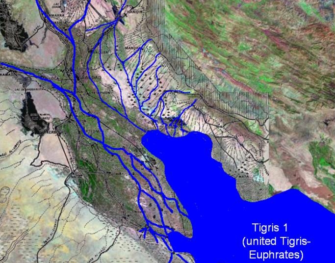
9) This phase, in which the Tigris and Euphrates rivers effectively coalesced near to Baghdad, and formed a complex of braided channels along the axis of the lobe, was characteristic of the fourth and third millennia BC.
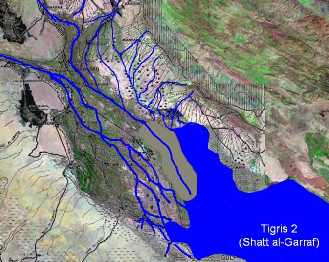
10) The separation of the Tigris and Euphrates courses, and the formation of a separate Tigris lobe, is a process which may have begun in the third millennium and continued in the following millennia, with rapid progradation and infilling of the shallow upper waters of the Gulf.
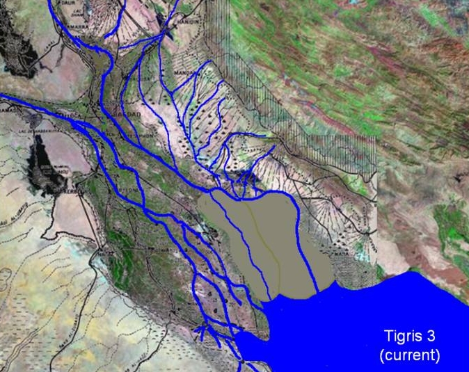
11) The continuation of this process, together with extension of the Karun-Karkeh delta, was responsible for the formation of the present landscape in the historical period.
GROWTH OF A FAN
Continuous accumulation of an alluvial fan Divergence of river-courses as the fan develops
This sequence demonstrates the pattern of development of major river-courses flowing across an accumulating alluvial lobe along a low gradient, with the consequent channel-shifts.
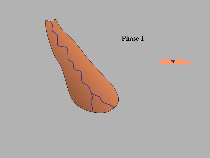
12) At an early stage in the sequence, the rivers flow axially along the lobe.
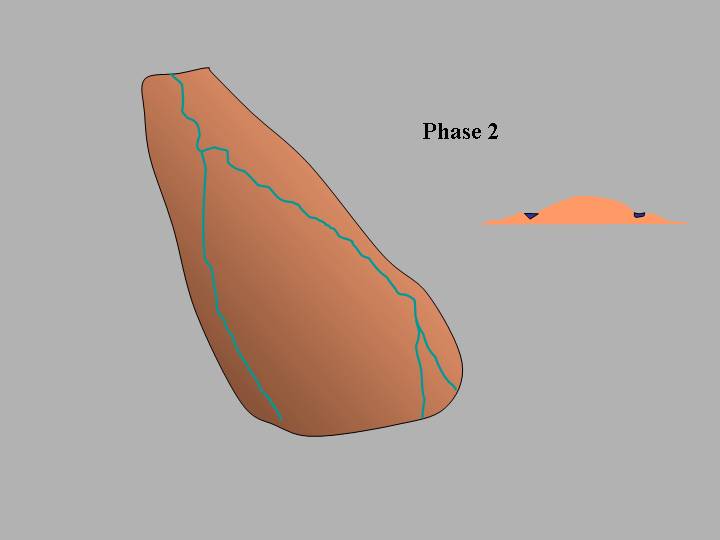
13) As sediment accumulates, the river-system splits into two, along the slopes of the fan.
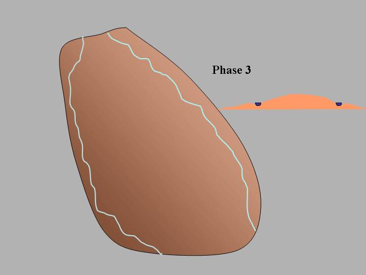
14) Finally, the river-courses flow along the edge of the fan, some distance apart, creating an interfluve or "mesopotamia" – the area between the rivers.
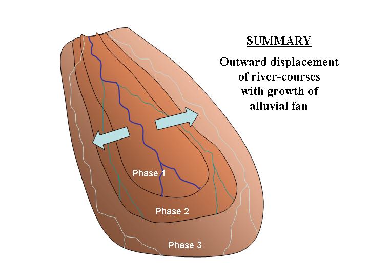
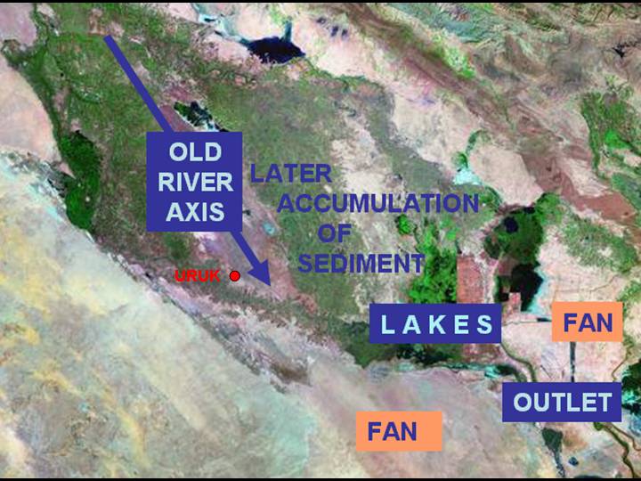
15) This view superimposes the phases, showing the outward displacement of the river-courses.
16) The development of the southern Mesopotamian Plain, and the patterns of settlement within it over the period from 4000 BC to the present day, can be explained by this model.
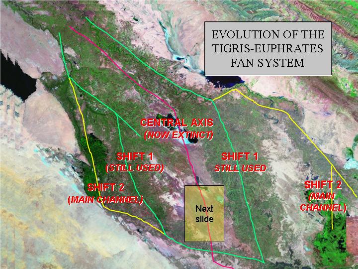
17) In the fourth millennium BC, the unified Tigris and Euphrates rivers ran down the spine of the elongated fan; by the beginning of the second millennium the two rivers appear to have split into separate channels, displaced outward from the central axis; in later historical times the two main watercourses have been further displaced, now running along the margins of the basin before being forced back together by the Batin and Karun-Karkeh fans, to flow through Basra to the present head of the Gulf. In consequence the central axis, once the best-watered and most fertile region, is now relatively arid and saline, in complete contrast to the landscapes which surrounded the earliest cities. By a fortunate side-effect of geomorphological history, therefore, archaeological evidence of this critical chapter of human history has been preserved "high and dry", relatively undisturbed both by later occupation and alluvial deposition.
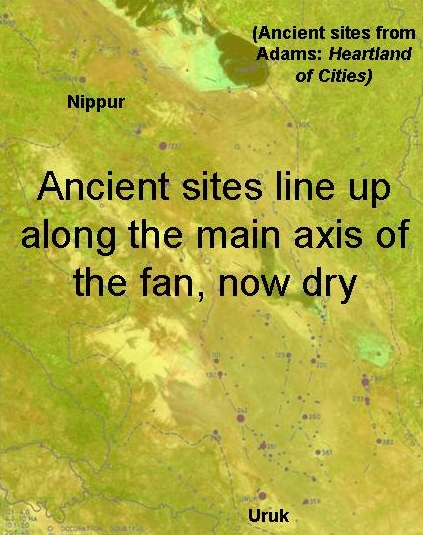
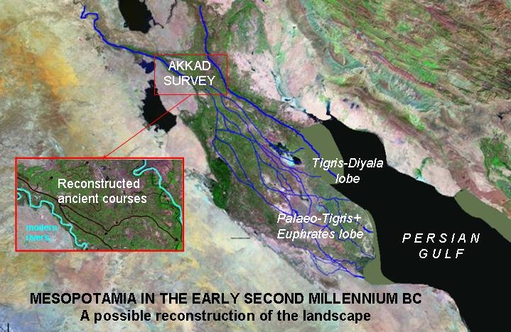
18) The surveys of R. M. Adams, together with Hans Nissen, have recovered a remarkable record of ancient settlement-history, which is one of the triumphs of modern archaeology. Tentatively related by Adams to reconstructed river-courses, this process is now being taken further by Jennifer Pournelle (San Diego), using declassified
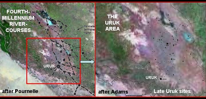
19) As is clear on the above images, the pattern of river-courses and associated settlements in the late-fourth millennium is associated with areas now dry lilac and purple colouring) and in places saline (blue).
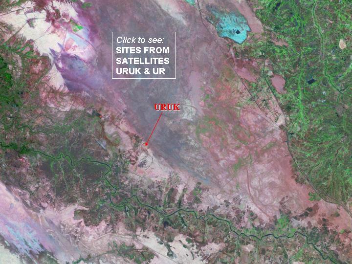
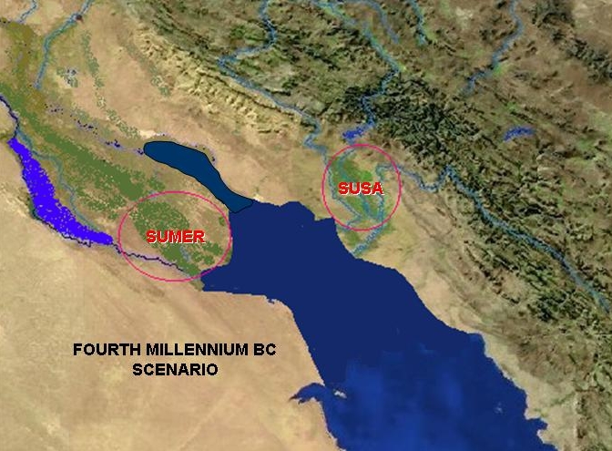
20) The site of Uruk itself (see SITES FROM SATELLITES for a sequence of images) would have been watered by a river-system flowing from north to south; the present path of the Euphrates (green colour, bottom) represents an outward displacement, following the basin edge and now cutting in a west to east direction through the end of the former fan lobe.
CONVERGENT FANS
Lateral and longitudinal fans
"Pinch" effects from the convergence of lateral fans, enclosing lakes
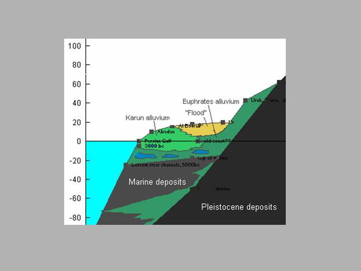
21) A geological section (height considerably exaggerated in relation to horizontal distance!) shows the interdigitation of Holocene fluvial and marine deposits, material laterally transported by the Karun-Karkeh river, and flood deposits in the basin behind (After Meehan). Like the rivers, the coastline would have been relatively unstable and sensitive to small changes in water-level.
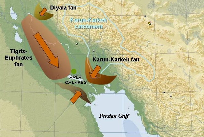
22) This map shows the constricting effect of the (old) Batin fan and the (rapidly-growing) Karun-Karkeh fan, with its extensive highland catchment-area (The green dot indicated a possible impact-crater visible on satellite imagery).

23) This map summarises the structural elements of the lower Mesopotamian basin.
24) In reconstructing the setting of ancient civilisations, it is necessary to re-create (if only in imagination) the landscapes of the time, both at a detailed local level and on a regional scale. This map combines a speculative image of the basin as a whole with a thumbnail image of the detailed work now being done by the Northern Akkad Survey (University of Ghent).
25) If these speculations are correct, it means that in the Uruk period – the time of the first cities – Sumer was separated from Susiana (the area around Susa, modern Khuzistan: see SITES FROM SATELLITES, Susa) by a body of salt-water, constituting the shallow upper reaches of the Persian Gulf. Contact between them (which is very evident in the material culture) must have taken place by boat.
CREDITS: 1-2 NASA Blue Marble true-colour global imagery [1km resolution]. 3-5/8-11/16-17/19-20/23-24 Landsat TM imagery provided by NASA: "You may use NASA imagery, video and audio material for educational or informational purposes, including photo collections, textbooks, public exhibits and Internet Web pages." 7 GLOBE DEM.