ArchAtlas journal articles which mention this site
Exploring Routes and Plains in Southwest Iran

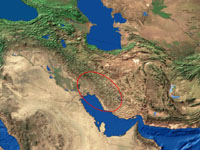
Satellite imaging has given a new dimension to fieldwork in the varied terrain of Southwestern Iran, where the Zagros mountains separate the Mesopotamian lowlands from highland Iran, and whose successive ridges enclose fertile intermontane valleys. These fertile enclaves were often settled as early as the Neolithic, and have a continuous history of occupation down to the present day. They gained a historical importance as stepping stones on routes through the mountains (both for transhumance and trade), and as nodal points in the formation of political units.
Environmental Change: The evolution of Mesopotamia

The areas that were occupied by early farmers and town-dwellers were often very different from the landscapes that can be seen in the same areas today. Some of the most important changes took place in the great river basins where urban civilisation first emerged. Southern Mesopotamia (Iraq), the land of the two rivers, has been transformed over the last six thousand years by the changing relationships between rivers, land and sea. Although the pattern has not yet been reconstructed in detail, satellite imagery can be used to outline the major processes of change, and to visualise what an extraordinary landscape this was at the time of the first cities.
 Occasional Papers (2009-)
 Site Visualisations