Important news about the threat to the Dept of Archaeology at the University of Sheffield... Read more...

Fertile Crescent

Steps Toward the Study of Seasonality and Trade
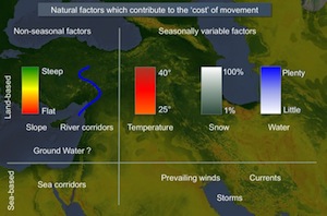
For the most part, the study of large-scale trade and exchange in the ancient world remains distanced from the physical hardships of real human travel. Ancient trade or, more neutrally, ancient ‘interaction’ is often discussed as if it took place between actors who inhabited a flat and unchanging spatial surface. In fact, topography, climate and seasonality are essential to understanding the changing forms and intensity of human travel that enabled ‘interdependence’ between communities of the Near East. This paper demonstrates some of the steps needed to reintegrate seasonality with the study of ancient trade.

Networks of interaction in Early Bronze Age Anatolia

Research carried out in Turkey over the last few decades seems to indicate that the Early Bronze Age in west and central Anatolia was a period in which new socio-political structures emerged whose mature development is reflected in the territorial entities of the Old Assyrian period. From the second half of the third millennium, we have evidence of social stratification both at the intra-site and inter-site level, accompanied by a wealth of prestige goods and public structures displayed in settlement and funerary contexts. This phenomenon is also paralleled by the rapid growth of long-distance relations both within Anatolia and with surrounding regions, at least partially triggered by the rise in metal demand of local and foreign elites.

Levant Harbour Towns in the Middle Bronze Age

Trading connections and routes play a very important part in the development (or re-development) of urban centres in the Middle Bronze Age Levant. This is particularly clear in the regions of Cilicia and the Amuq Plain in the Hatay, in the north-east corner of the East Mediterranean, where at the beginning of the Middle Bronze Age we have evidence of large-scale public buildings and fortification systems which represent the revival of complex political and economic structures, following a collapse at the end of the Early Bronze Age. A key role in this is played by harbour towns on the Cilician and Levantine coasts, which have an important part in the articulation and exploitation of maritime and inland routes connecting different zones and their resources. This in turn leads, by the beginning of the Late Bronze Age, to the formation of a symbiotic network of semi-dependent kingdoms which link these different inland and coastal zones in a single interactive socio-economic system.

Roads and caravanserais in Medieval Syria

New research is currently being carried out in order to collect supplementary data, both historical and archaeological, on the road networks of Medieval Bilād al-Šām and their related facilities. Supported by the material evidence of caravanserais, the aim of the research is to propose a reconstruction and a preliminary analysis of the region's communication axis from the beginning of the Ayyubid period till the end of the Mamluk. The preliminary character of the reflections offered in this article will hopefully be pursued more thoroughly in the completion of a larger project now in its final phase.

Ancient Near Eastern Route Systems: From the Ground Up

A particularly common trace of ancient route systems on the ground is the 'hollow way'. In the Middle East hollow ways, like their counterparts in the UK and Europe, appear as long, usually straight valleys. This paper examines the traces of these ancient route systems in the Ancient Near East according to their pattern, processes of formation, parallels elsewhere, and their function.

Unscrambling the 'Uplands'

This presentation forms part of a a collaborative British-Syrian project called Settlement and Landscape Development in the Homs Region, Syria, that seeks to compare human activity in adjacent but contrasting landscapes in a typical part of western Syria. In this case we focus on an upland landscape, where stone architecture is the expectation. In the traditional literature, most discussion of such areas has concentrated upon the evidence for activity of Graeco-Roman date - the Dead Cities of the Limestone Massif on north-western Syria are an excellent example. However, we have very little knowledge of the evidence for earlier periods. This is, we suspect, because we have little idea of what we should be looking for.

Agricultural and Pastoral Landscapes in the Near East

The Near East presents particular challenges to the study of past landscapes. Remote sensing has been a part of archaeology for a century, and aerial photographic coverage is now the ideal and standard for field survey basemaps. Such coverge, however, is not globally available. In the modern Middle East, for example, easy access to aerial photography is often impossible to obtain. As a result, archaeologists have turned to satellite imagery. Unfortunately, the resolution of space-based imaging systems such as Landsat and SPOT is often too coarse for archaeological features. To some extent, this issue has been solved by the availability of commercial high-resolution imagery. However, such imagery is expensive and documents the modern developed landscape. Over the last decade, Near Eastern archaeologists employed a new satellite resource that resolves many of these issues: the declassified CORONA intelligence program.

Mat Ashur - Land of Ashur

This paper gives an introduction to the archaeology of the Assyrian heartland where only a limited investigation outside of the big centres has taken place in the field. With methods of landscape archaeology and remote sensing techniques it is possible to survey a wide area and integrate detected landscape features into an historical framework and social and chronological contexts.

Quantitative approaches to the remote sensing of ancient settlements

Tells, the characteristic settlement mounds of the Near East, are visible remains of the first human settlement system. Often piled up to considerable heights by the debris of millennia of settlement activity, they provide characteristic physical signatures, such as specific elevation profiles or soil changes, which – potentially – can be detected in data available from space-borne sensors. Using methods from pattern recognition and statistical learning, we systematically evaluated digital elevation models and multispectral imagery to provide means for a machine based detection and mapping of these archaeologically relevant settlement sites.

Tellspotting

How do we know where sites are? In the arc from south-east Europe to north-west India, early farming sites often form prominent mounds (known from the Arabic term as tell settlements). Such sites were often occupied over many millennia, and some of them grew into major cities during the Bronze Age; though thereafter settlement tended to shift to new locations away from the mounds. These early settlement-mounds form characteristic features of the landscape, and in fact are visible from space. Release of data from the Shuttle Radar Topography Mission in 2000 has provided the opportunity to identify the positions of many known archaeological sites of this type and to recognise others. Tellspotting is now not only an agreeable hobby, but has a high-tech methodology: an invaluable tool in reconstructing settlement-history and a means of inventorizing these outstanding sources of archaeological information.

Virtual Survey: a semi-automated tellspotting algorithm

Following the observation that prehistoric and early historic settlement-mounds (tell settlements) in parts of the Near and Middle East can be recognized in the SRTM 90m terrain model (Sherratt, Antiquity 2004) an algorithm has been developed to do this automatically, using current techniques of computer modeling.

The Origins of Farming in South-West Asia

Satellite images provide a convenient means of understanding why early sites were chosen for settlement, and of visualising the routes that linked them. These two factors (location amongst critical resources, and position in wider networks) interacted with each other: oases were occupied both because of their local advantages, and also because they acted as stepping-stones on routes carrying desirable materials over long distances. This presentation applies these arguments to a critical problem in prehistoric archaeology: where precisely did farming first emerge in western Asia?

Trade Routes: Growth of Global Trade

One of the most evident features of the human past is the growing scale of connections between areas, shown for instance by the movement of materials (such as the Obsidian Trade). Although the current phase of "globalisation" is unique in its range and impact, it was preceded by many earlier episodes of expansion and collapse. These maps reconstruct how such networks develop, and show how they follow a logic reflecting both their own geometry and that of the Earth's surface, and how they sometimes come to a catastrophic stop.

Environmental Change: The evolution of Mesopotamia

The areas that were occupied by early farmers and town-dwellers were often very different from the landscapes that can be seen in the same areas today. Some of the most important changes took place in the great river basins where urban civilisation first emerged. Southern Mesopotamia (Iraq), the land of the two rivers, has been transformed over the last six thousand years by the changing relationships between rivers, land and sea. Although the pattern has not yet been reconstructed in detail, satellite imagery can be used to outline the major processes of change, and to visualise what an extraordinary landscape this was at the time of the first cities.